
SEMICONSOLIDATED SAND AQUIFERS
Sediments that primarily consist of semiconsolidated sand, silt, and clay, interbedded with some carbonate rocks, underlie the Coastal Plains that border the Atlantic Ocean and the Gulf of Mexico. The sediments extend from Long Island, New York, southwestward to the Rio Grande, and generally form a thick wedge of strata that dips and thickens seaward from a featheredge at its updip limit. Coastal Plain sediments are water-laid and were deposited during a series of transgressions and regressions of the sea. Depositional environments ranged from fluvial to deltaic to shallow marine, and the exact location of each environment depends upon the relative position of land masses, shorelines, and streams at a given point in geologic time. Complex interbedding and variations in lithology result from the constantly-changing depositional environments. Some beds are thick and continuous for tens to hundreds of miles, whereas others are traceable only for short distances. Consequently, the position, shape, and number of the bodies of sand and gravel that form aquifers in these sediments varies greatly from place to place.
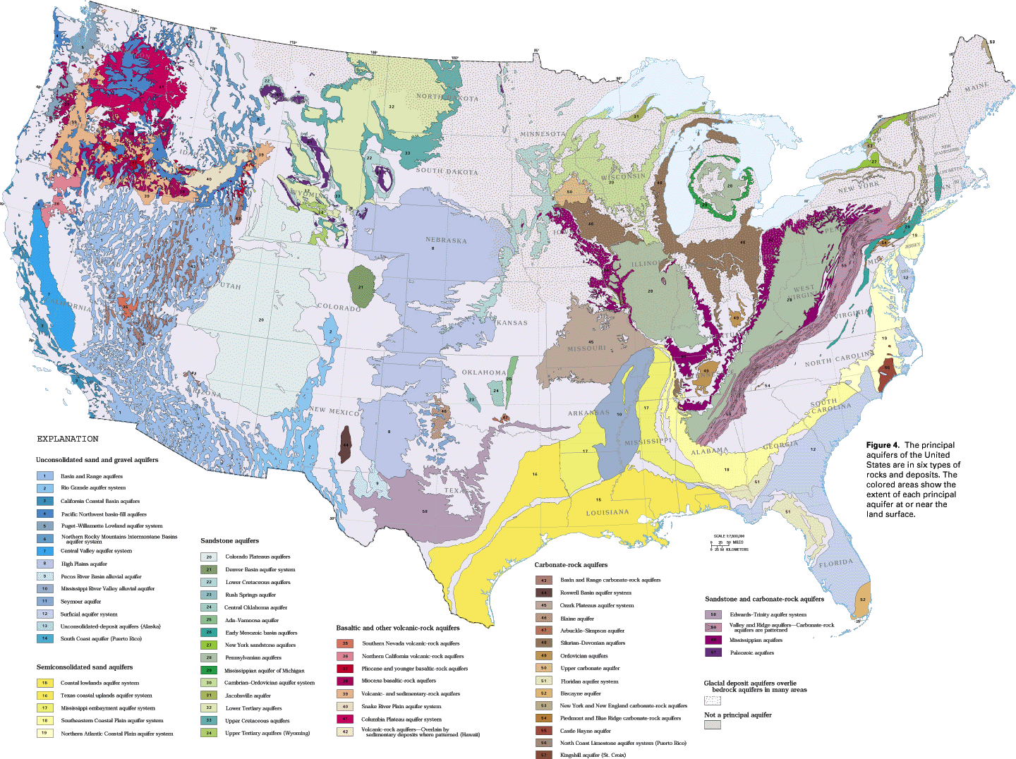
The semiconsolidated sand aquifers have been grouped into five aquifer systems (fig. 4) which interfinger with and grade into each other. Within each aquifer system, the numerous local aquifers have been grouped into regional aquifers that are separated by regional confining units consisting primarily of silt and clay, but locally are beds of shale or chalk. The rocks that comprise these aquifer systems are of Cretaceous and Tertiary age. In general, the older rocks crop out farthest inland, and successively younger rocks are exposed coastward.
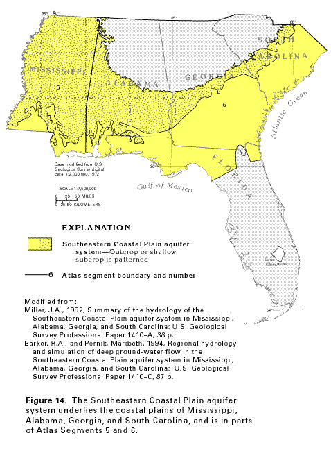
The Southeastern Coastal Plain aquifer system in Atlas Segments 5 and 6 (fig. 14) is a representative example of a complex aquifer system in semiconsolidated sediments. The predominantly clastic sediments that comprise the aquifer system crop out or are buried at shallow depths in large parts of Mississippi and Alabama, and in smaller areas of Georgia and South Carolina; toward the coast, the aquifer system is covered either by shallower aquifers or confining units. Some of the aquifers and confining units of the Southeastern Coastal Plain aquifer system grade laterally into adjacent clastic aquifer systems in North Carolina, Tennessee, and Mississippi and adjacent States to the west; some also grade vertically and laterally southeastward into carbonate rocks of the Floridan aquifer system.
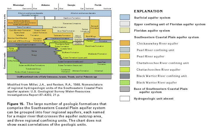
Numerous geologic formations have been identified in the complexly interbedded rocks of the Southeastern Coastal Plain aquifer system. Likewise, many local aquifers and confining units are present in the area underlain by the aquifer system. Based on similarities in their hydraulic characteristics and water levels, sequences of local aquifers can be grouped into regional aquifers; sequences of local confining units can be grouped into regional confining units in the same manner.
The sediments of the Southeastern Coastal Plain aquifer system have been grouped into four regional aquifers separated by three regional confining units. The principal geologic formations that comprise these regional hydrogeologic units are shown in figure 15. The regional aquifers chiefly consist of coarse to fine sand, but some locally include beds of gravel and limestone. In each aquifer, the coarser-grained material, such as gravel and coarse sand, generally is farthest inland near sediment source areas; the amount of silt and clay increases coastward. The regional confining units are mostly clay and mudstone with local shale beds except for a thick sequence of chalk in Alabama and Mississippi (the Selma Group) which forms an effective confining unit. Each of the regional aquifers is named for a major river along which the sediments that comprise the aquifer are well exposed. From shallowest to deepest, the regional aquifers are the Chickasawhay River aquifer, the Pearl River aquifer, the Chattahoochee River aquifer, and the Black Warrior River aquifer (fig. 15). Each regional confining unit bears a name similar to that of the aquifer it overlies; for example, the Pearl River confining unit overlies the Pearl River aquifer and separates it from the shallower Chickasawhay River aquifer (fig. 15). All the regional hydrogeologic units are not present everywhere in the coastal plain. For example, the Chickasawhay River aquifer occurs only in southern Mississippi and southwestern Alabama; the Chattahoochee River aquifer is absent in a large area in western Alabama and southeastern Mississippi, and so on.
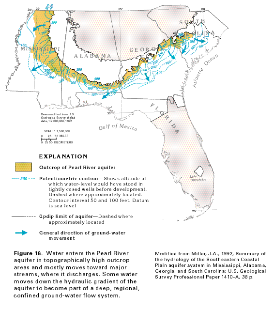
Recharge to the regional aquifers is from precipitation that falls on inland, topographically high aquifer outcrop areas. A map of the potentiometric surface of the Pearl River aquifer (fig. 16) shows that in outcrop areas, where unconfined conditions exist, the water moves from high altitudes toward streams. As the water moves coastward, down the hydraulic gradient (slope of the potentiometric surface), it becomes confined and the potentiometric surface becomes smoother, in contrast to its highly irregular shape in updip areas. Water in the aquifer moves along short flow paths in and near outcrop areas and along longer, regional flow paths in downgradient areas. The Pearl River aquifer grades into carbonate rocks of the Floridan aquifer system in southern Alabama, southern Georgia and southeastern South Carolina (fig. 15), and into clastic beds of the Mississippi embayment aquifer system in southwestern Mississippi.
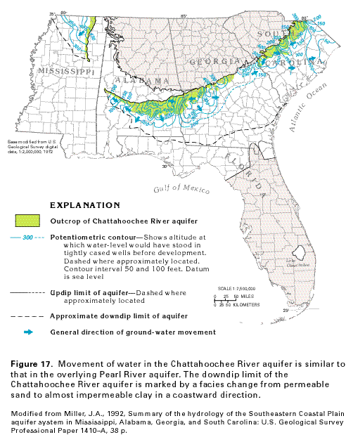
The potentiometric surface of the Chattahoochee River aquifer (fig. 17) resembles that of the Pearl River aquifer. The contours are irregular in outcrop areas, reflecting the influence of incised streams between high-altitude recharge areas. In the confined part of the aquifer, water moves along gentler hydraulic gradients and generally down the dip of the beds. The downdip limit of this aquifer in Mississippi, Alabama, and Georgia is the area in which the sands that comprise the aquifer change to clays.
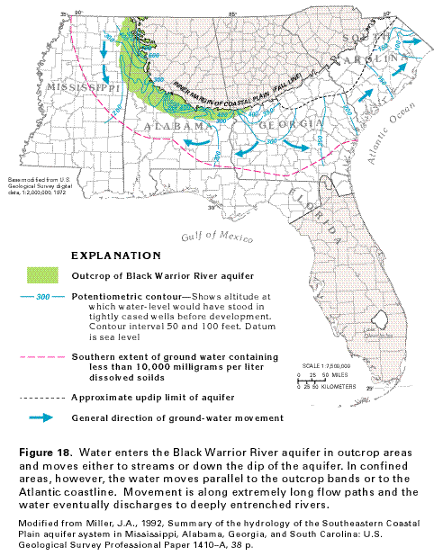
Although movement of water in the outcrop areas of the Black Warrior aquifer is similar to that of the shallower aquifers in the aquifer system, water in the confined parts of the aquifer moves differently. As shown by the flow-direction arrows in figure 18, important components of flow in the deep, confined parts of the aquifer are parallel to the outcrop belt of the aquifer in Mississippi and are coast-parallel in South Carolina. The water also moves along extremely long flow paths toward deeply entrenched regional drains such as the Tombigbee, the Alabama, and the Chattahoochee Rivers once it enters the confined parts of the aquifer. The downdip limit of ground-water movement in the Black Warrior River aquifer is defined as the point at which the aquifer contains water having dissolved-solids concentrations of 10,000 milligrams per liter. Although permeable sediments equivalent to this aquifer extend to the Gulf and Atlantic Coasts, little ground-water movement is thought to occur downdip of the 10,000 milligrams per liter dissolved-solids line. Coastal plain aquifers commonly contain unflushed saline water in their deep, downdip parts.
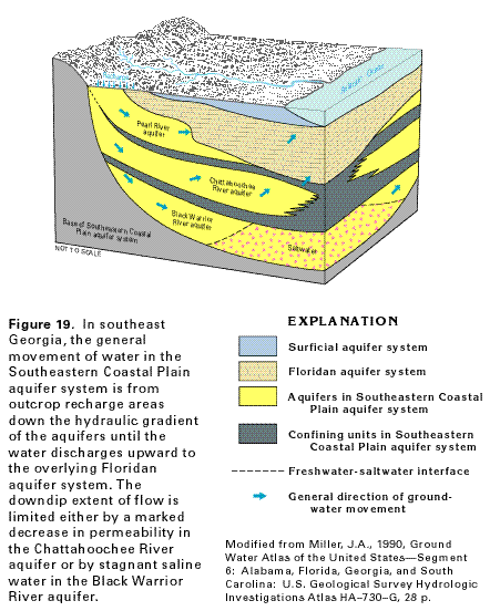
The general movement of water in the southeastern Coastal Plain is summarized in figure 19, which represents conditions in southeastern Georgia. The figure shows the relation between the Southeastern Coastal Plain aquifer system and the carbonate rocks of the Floridan aquifer system. Water enters the Pearl River aquifer where it crops out adjacent to the crystalline rocks that form the base of the Southeastern Coastal Plain aquifer system. Some of the water moves coastward in the clastic sediments of the Pearl River aquifer and laterally into the Floridan aquifer system where sands change to limestone; some water moves downward into the Chattahoochee River aquifer from the Pearl River aquifer where the two are in contact. The Black Warrior River aquifer is recharged in this area only by downward leakage across the confining unit that completely overlies it. Where the Chattahoochee River and the Black Warrior River aquifers are confined, water moves laterally through the aquifers. Near the coast, flow is blocked either by an increase in the amount of clay in the aquifer (Chattahoochee River aquifer) or by stagnant saline water (Black Warrior River aquifer). The flow becomes predominantly vertical as the water leaks upward to shallower aquifers or to the ocean. Water leaks downward from the Floridan aquifer system to the Southeastern Coastal Plain aquifer system, or leaks in the opposite (upward) direction, depending on the direction of decreasing hydraulic head between the two aquifer systems. The horizontal flow arrow shown in the Black Warrior River aquifer near the right side of the figure represents the coast-parallel direction of flow in this aquifer.
Other semiconsolidated sand aquifers are grouped into extensive
aquifer systems as shown in figure 4.
The Northern Atlantic Coastal Plain aquifer system extends from
North Carolina through Long Island, New York, and locally contains
as many as 10 aquifers. The Mississippi Embayment aquifer system
consists of six aquifers, five of which are equivalent to aquifers
in the Texas coastal uplands aquifer system to the west. The coastal
lowlands aquifer system contains five thick, extensive permeable
zones.