INTRODUCTION
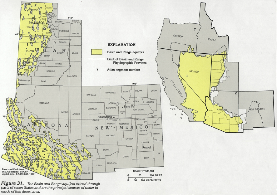
The Basin and Range aquifers extend through about 200,000 square miles of the southwestern United States and underlie most of Nevada and parts of eastern California, southern Oregon and Idaho, western Utah, southern Arizona, and southwestern New Mexico. The aquifers extend through most of the Basin and Range aquifers as described in this report includes the aquifers of western Utah, southern Arizona, and southwestern New Mexico (fig. 31). The aquifers comprise the eastern part of the Great Basin aquifer system in Utah and the western part of the Southwest alluvial basins aquifer system in Arizona as defined by U.S. Geological Survey Regional Aquifer-System Analysis studies. The western part of the Basin and Range aquifers is described in Chapter B of this Atlas, which pertains to California and Nevada.
The Basin and Range aquifers are the principal sources of ground water in western Utah and southern Arizona. The aquifers are present in about 120 alluvium-filled basins interspersed between ranges of mountains. About 150,000,000 acre-feet of recoverable ground water is in storage in the upper 100 feet of the saturated sediments of these basins. The ground water in some basins is extensively utilized, and large water-level declines have occurred; in other basins, population is sparse, ground water is little utilized, and water levels are stable.
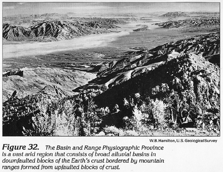
The 95,000-square-mile are of the aquifers in Segment 2 ranges in altitude from about 150 feet near Yuma in southwestern Arizona to more than 10,000 feet at the crests of a few desert mountain ranges. Most of the mountain ranges protrude 3,000 to 6,000 feet above the level of the surrounding basins and extend in a northerly or northwesterly direction for 10 to 50 miles. The land surface of the basins generally slopes gently from the adjacent mountain fronts toward the flat-lying central parts of the basins, where dry lake beds (playas) or shallow sandy stream channels are common (fig. 32). Some basins are topographically closed, and all surface water drains to a central lake or playa; other basins are topographically open, and surface water may flow between basins. The high temperatures and arid climate of the desert region result in minimal streamflow, and the stream channels and playas generally are dry.
HYDROGEOLOGIC UNITS
Structure and lithology are the principal geologic factors that affect the occurrence and movement of ground water in the Basin and Range aquifers. The principal aquifers are in thick deposits of basin fill in valleys bounded by mountain ranges formed mostly of relatively impermeable bedrock.
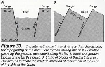
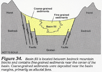
The structural deformation that produced the system of basins and ranges generally began in Tertiary time with block faulting along steeply dipping normal faults. Crustal extension produced horst and graben blocks in some places (fig. 33A) and tilted blocks in others (fig. 33B). The downthrown parts of the blocks became basins; the upthrown parts became mountain ranges. Vertical displacement across the fault zones exceeded 10,000 feet in some areas. Many of the resulting basins are asymmetrical because the grabens are not centered in the valleys. As the mountain blocks were uplifted and eroded, sediment was carried by streams into the basins, and alluvial fans were formed. The fans coalesced to produce broad surfaces that sloped gently to the center of the basins, where fine-grained sediments were deposited in lakes and playas (fig. 34). Coarse-grained sediments tended to be deposited near the steeper margins of basins. Fault movement resulting from continuing deformation offset some of these older sediments. Deformation and sedimentation occurred at different rates through the area; as a result, the thickness, areal extent, and grain size of the basin fill are highly varied.
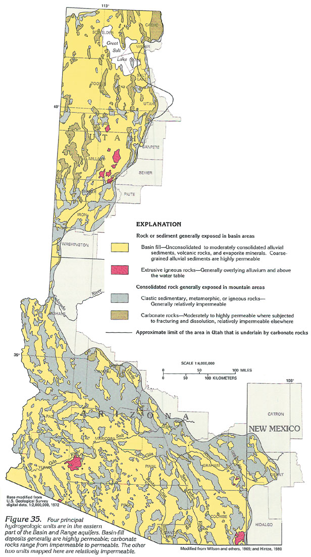
Basin fill (fig. 35) primarily consists of unconsolidated to moderately consolidated, well- to poorly sorted beds of gravel, sand, silt, and clay deposited on alluvial fans, pediments, flood plains, and playas. More cemented or compact sediments in the older basin fill and finer grained sediments near the center of the basin are less permeable than the coarser grained sediments near the margins of the basins. Evaporites, such as gypsum, anhydrite (calcium sulfate), and halite (rock salt) are present in the deeper fine-grained sediments of the central parts of some basins. Extrusive volcanic rocks also are interspersed with basin fill in some basins; volcanic rocks overlie basin fill in a few areas. The thickness of the basin fill is not well known in some basins but ranges from about 1,000 to 5,000 feet in many basins and may exceed 10,000 in a few deep basins in Utah and south-central Arizona.
Stream alluvium that consists of moderately to well-sorted, fine to coarse send with gravel, silt, and clay is present along most of the larger stream channels. These deposits are about 100 feet thick and 1 to 2 miles wide along the Gila, Salt, and Santa Cruz Rivers in Arizona and exceed 700 feet in thickness along the lower Colorado River.
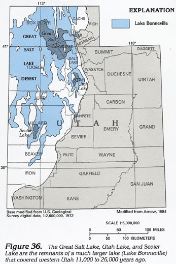
Extensive layers of sediments also were deposited on the bed of Lake Bonneville, a Pleistocene lake that covered about 20,000 square miles of western Utah (fig. 36) during the last phase of the great ice age (26,000-11,000 years ago). These sediments ranged in size from sand, gravel, and boulders near the margins of the ancient lake to clay, silt, and sand in the deeper parts of the lake. The lake remained relatively stable for long periods of time as the volume of water that flowed into the lake was virtually balanced by the volume of outflow and evaporation. Eventually, the rate of evaporation exceeded the rate of inflow, and the lake level progressively declined; the once large body of freshwater was reduced to bodies of brine that today are the Great Salt Lake and Utah Lake. As Lake Bonneville retreated and evaporated, extensive deposits of halite (rock salt) were formed in the lakebed sediments and on the surface of what is now the Great Salt Lake Desert. Important sources of fresh ground water are present in coarser grained sediments near the mountain fronts of this area; saline ground water is common in shallow aquifers or in fine-grained sediments in the central parts of basins.
Bedrock in present in the uplifted blocks of the mountain ranges and beneath the basin fill in the valleys. Bedrock consists of consolidated carbonate rocks or metamorphic, igneous, and clastic rocks that are relatively impermeable unless extensively fractured (fig. 35). Fracturing in carbonate rocks (limestone and dolomite) may enable ground water to circulate through the fractures where the water can dissolve the slightly soluble crock and enlarge and increase the size and number of pathways for water movement through the rock. Such dissolution eventually can change a relatively impermeable carbonate rock into a permeable water-yielding unit. Carbonate rocks predominate in a 20,000- to 30,000-foot thick sequence of Paleozoic and Lower Mesozoic rocks in an extensive area of western Utah in Segment 2 (fig. 35) and southern and eastern Nevada in Segment 1. The location of solution-altered zones of enhanced permeability within these carbonate rocks is poorly known. However, some data indicate that ground water might flow between basins through permeable carbonate rocks in the mountains of west-central Utah, and water might flow from recharge areas in the mountains to local basins through permeable carbonate rocks bordering the northeastern part of the aquifer system. Although extrusive igneous rocks (primarily basalt) can be permeable in local areas, most other types of consolidated rock are not sufficiently permeable to transmit large volumes of water, and bedrock generally forms a relatively impermeable boundary to the Basin and Range aquifers.
RECHARGE AND DISCHARGE
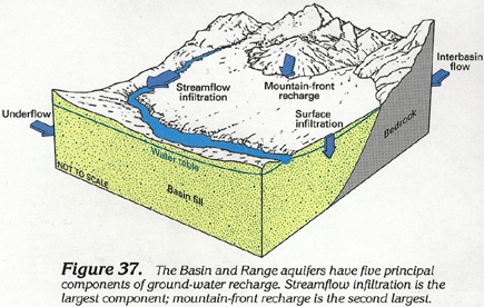
Recharge to the aquifers primarily is derived from precipitation in the mountains surrounding the basins. Average annual precipitation ranges from about 4 to 8 inches in the basins, is 16 inches or more in most mountain ranges, and exceeds 30 inches in a few of the higher mountain ranges. The generally arid climate of the area is characterized by high summer temperatures and large rates of evaporation and transpiration, particularly at lower altitudes and southern latitudes. These climatic conditions cause almost all the precipitation in the basins and most of the precipitation in the mountains to be lost to evapotranspiration. Only about 5 percent of the precipitation that falls recharges the basin-fill aquifers. Water not lost to evapotranpiration in the mountains forms runoff in streams or infiltrates the soil and upper zones of fractured bedrock, where it may flow to springs of through fractures and discharge into the basin fill at the base of the mountains. Larger streams in the basins often flow on alluvium that is unconsolidated, well sorted, and highly permeable. These sediments enable rapid infiltration of streamflow, and the streams may recharge the basin-fill aquifers at considerable distance from the mountains. Small ephemeral streams and water flowing through fractured bedrock generally recharge the aquifers near the mountain fronts and together constitute mountain-front recharge (fig. 37). When the stream and aquifer are in direct hydraulic connection, as is the case along the Colorado River in Arizona, the surface and ground waters may function as an interdependent stream-aquifer system. Precipitation supplies about 2,500,000 acre-feet per year of recharge to the Arizona part of the Basin and Range aquifers and about 1,500,000 acre-feet per year of recharge to the Utah part of the aquifers.
Underflow and interbasin flow can be significant components of recharge or discharge in some basins. Many basins are connected by basin fill in narrow valleys between mountain ranges. Ground water flows through these valleys from higher altitude basins to lower altitude basins. This underflow commonly ranges from a few hundred to a few thousand acre-feet per year. A few wider valleys between basins have underflow that exceeds 30,000 acre-feet per year. Interbasin flow is a significant component of recharge or discharge only in areas of solution-altered carbonate rocks, primarily in western Utah. In parts of western Utah, ground water flows through deep, enlarged bedrock fractures from basin to basin or under several basins and discharges at distant points. Few data exist to document the location or magnitude of interbasin flow. However, several springs in western Utah likely yield water from carbonate rocks and have a combined discharge of about 45,000 acre-feet per year.
Surface infiltration of water is an important component of recharge to the Basin and Range aquifers. In the northern part of the aquifers, cooler temperatures and greater precipitation enable direct recharge from precipitation. In extensively developed parts of the aquifers, additional recharge is the result of human intervention in the hydrologic cycle. Part of the water used to irrigate commercial crops, golf courses, and other vegetation percolates into the basin fill and ultimately recharges the aquifers. Water in reservoirs, canals, and outfalls from sewage-treatment plates also can percolate downward and recharge the aquifers. Although the quantities of water recharged are not well documented, some data indicate that about one-half of the irrigation water applied to fields in Arizona ultimately recharges the aquifers. Between 1915 and 1980, about 90,000,000 acre-feet of irrigation water is estimated to have recharged the aquifers in Arizona. Most of this water was withdrawn from the aquifers; about 184,000,000 acre-feet of water was withdrawn in Arizona between 1915 and 1980.
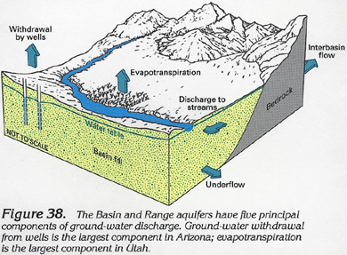
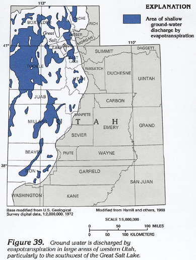
Discharge from the aquifers is by evapotranspiration, discharge to streams and springs, underflow, interbasin flow, and withdrawal by wells (fig. 38). Evapotranspiration is the largest natural component of ground-water discharge. Ground water can be directly lost to evaporation in areas of shallow water table such as wet playas, marshes, and salt flats. Transpiration is a large component of ground-water discharge in areas where vegetation obtains most of its water from the water table. Thick groves of salt cedar, cottonwood, or other plants transpire large volumes of water from tree-lined banks of many perennial streams; brush, grass, and other phreatophytes transpire ground water in many other areas of shallow water table. Ground water discharges by evapotranspiration in an extensive area of the Great Salt Lake Desert, particularly to the southwest of the Great Salt Lake in Utah (fig. 39). Less extensive areas of ground-water discharge by evapotranspiration are present in low-lying parts of many basins in Utah and Arizona. Prior to ground-water development, evapotranspiration was about 1,300,000 acre-feet per year along the lower Colorado River in Arizona, and about 700,000 acre-feet per year along the Gila River. Natural evapotranspiration can decrease when ground-water withdrawal lowers the water table under the phreatophytes.
Ground water discharges to streams or lakes in areas where the water level in the aquifer is higher than the level of the stream or lake bed (fig. 38). This situation can occur where a constriction in the width or thickness of the aquifer forces ground water to the surface, or where ground water flows toward a stream from aquifers of higher altitude on either side of the stream. In arid climates, perennial flow in streams that cross many miles of basin fill usually is maintained by ground-water discharge from underlying aquifers. Prior to ground-water development, the Gila River and its principal tributaries, the Salt, Verde, and San Pedro Rivers were perennial. These rivers and the Colorado River, which is still perennial, received ground-water discharge from aquifers in most of basins they crossed. The banks of many perennial streams in Arizona are covered by trees and other vegetation that obtain water from the aquifers. Most perennial streams in Utah are located along the eastern margin of the aquifers and drain the Wasatch Range and Wasatch Plateau or other high mountains to the east; streamflow generally provides recharge to aquifers underlying the alluvial fans before the streams enter Great Salt Lake, Utah Lake, or other lakes.
Underflow and interbasin flow are additional components of ground-water discharge that can be large in some basins. The factors that relate to underflow and interbasin recharge discussed above also apply to discharge.
WATER-LEVEL CONDITIONS
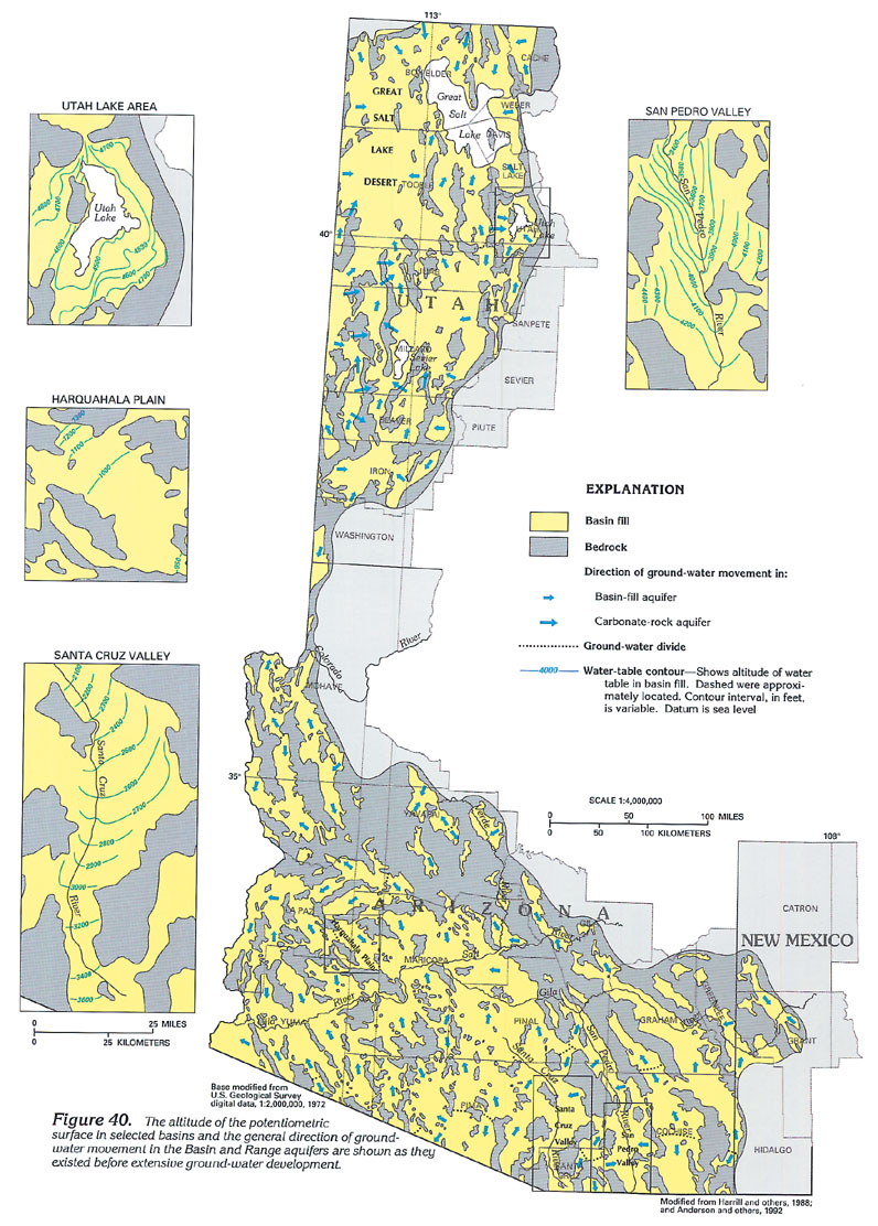
The water levels and direction of ground-water movement in a basin are determined by the geometry of the bedrock surrounding the basin and by the location and quantity of recharge and discharge within the basin. Although ground water flows through the basin-fill aquifers from areas of recharge to areas of discharge, the complex and partly interconnected network of aquifers in the basins causes ground water to flow in many different directions, and the hydrology of each basin is unique. As indicated in figure 40, water generally moves from recharge areas along the margins of the basins either toward discharge areas in the central parts of the valley (for example, Utah Lake, Utah, or San Pedro Valley, Ariz.), or toward discharge areas at the downgradient end of the valley (for example, Harquahala Plain, Ariz.).
The location and quantity of recharge and discharge also affects the shape of the potentiometric surface in the basin-fill aquifers. If little recharge occurs near the margin of the basin, water-level contours will be oriented approximately straight across the valley, as is the case in the Harquahala Plain. If larger quantities of recharge occur along the basin margin, water-level contours may be slightly to severely curved and oriented toward the center of the valley where ground water may discharge by evapotranspiration, to streams, or from wells. Before extensive ground-water withdrawals, the recharge along the margin of the San Pedro Valley in Arizona was larger than the rate of underflow down the valley, and the excess water was discharged to the river, as indicated by a marked curvature of the water-level contours (fig. 40). In valleys were basin-margin recharge is moderate and discharge occurs as a varied combination of evapotranspiration, seepage to streams, withdrawal from wells, or underflow, the water-level contours may be of more varied shape, as in the Santa Cruz Valley of Arizona. Lakes and playas are the sole discharge areas in a few valleys. A closed ground-water basin can result if all ground-water recharge and discharge occurs within the valley, and little or no water moves beyond the valley.
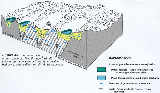
Ground water also flows through fractures and solution openings (primarily in carbonate rocks) that underlie and border the basin fill in parts of western Utah (fig. 41). If the fractures and solution openings are numerous and extensive enough, ground water may flow through the permeable bedrock from basin to basin, or beneath basins from recharge areas in distant mountains to discharge areas in the Great Salt Lake Desert, the Great Salt Lake, or the Sevier Lake area (fig. 40). The prevalence and lateral extent of such openings are poorly defined by available data. However, the carbonate rocks generally are much less permeable than the basin fill and have only scattered zones of enhanced permeability that yield water to bedrock springs or enable interbasin flow.
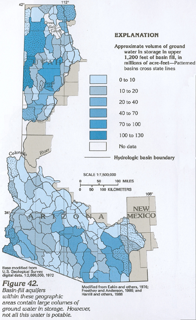
Before extensive ground-water development, about 900,000,000 acre-feet of ground water was in storage in the upper 1,200 feet of the basin fill in the Arizona part of the aquifer system. Incomplete data from Utah indicate that about 800,000,000 acre-feet of water may have been in storage in the upper 1,200 feet of basin fill in this area. The volume of ground water in storage in basins in Arizona and Utah (fig. 42) is estimated to range from less than 5,000,000 acre-feet in areas along the northern margin of the aquifer system in Arizona to more than 70,000,000 acre-feet in three large areas of western Utah. The volumes of ground water in storage in the basins in Arizona and Utah are only approximations because little is known about the subsurface extent, thickness, and water-yielding character of the basin-fill sediments in many areas. Not all the ground water in storage is potable. Water in the deeper parts of most basins contains larger concentrations of dissolved solids than water in the shallower parts of the basin. Most of the ground water under the Great Salt Lake Desert and Sevier Lake area is saline or brine.
The volume of ground water in storage in the basin-fill aquifers is large in comparison to the annual rate of recharge to the basins. Most basins contain between 200 and 2,000 times as much water in storage as they receive from annual recharge. In basins that contain relatively small volumes of water in storage and have relatively large recharge (such as the basins near the Colorado River in Arizona), only about 5 times as much water may be in storage than that received from recharge. In basins that have large volumes of water in storage and minimal recharge, about 14,000 times as much water may be in storage than that received from recharge.
Large rates of ground-water withdrawal can cause areally extensive water-level declines, decrease natural discharge, and deplete streamflow. Persistent large rates of withdrawal can cause water-level declines to extend throughout a basin. As water levels are lowered, the natural ground-water gradients may be decreased or reversed in some areas, and ground-water flow toward areas of natural discharge may decrease; reversal of ground-water gradients may decrease or eliminate natural discharge. Discharge to streamflow and evapotranspiration also may decrease or cease if the shallow water table declines below the level of the streambed or below the root zone of phreatophytes. Ground-water withdrawal can cause depletion of streamflow by lowering the water table near the stream. The greater depth to ground water enables more streamflow to infiltrate, thereby inducing additional ground-water recharge.
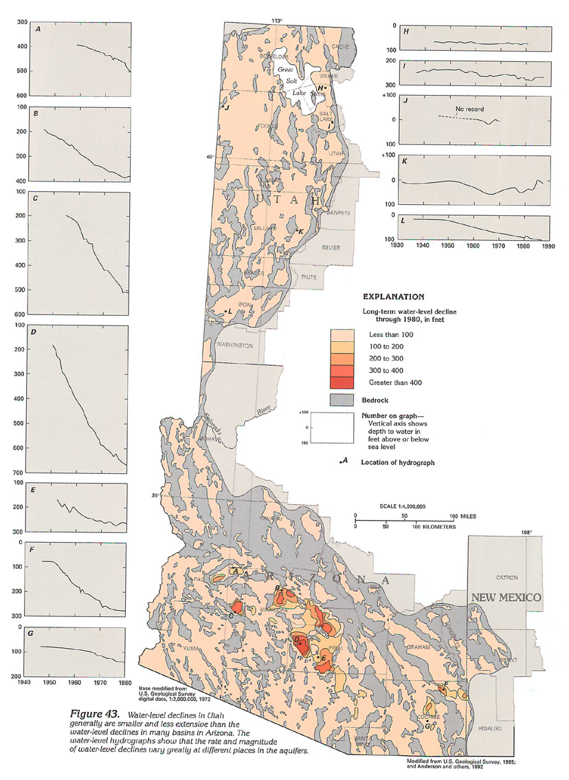
Water-level declines are the largest and most widespread effect of ground-water withdrawal. Major agricultural regions have undergone the largest water-level declines, which exceeded 450 feet through 1980 in some areas in Arizona and exceeded 70 feet in parts of Utah (fig. 43). Arizona generally has had larger water-level declines than Utah, primarily because of the larger rates of withdrawal in Arizona. Water-level declines have been relatively small in basins along most of the eastern margin of the aquifer system in Utah, where withdrawal is small, and along the Colorado River, where induced recharge from streamflow and lakes has moderated declines. Along parts of the Colorado River, water levels rose following agricultural development because of infiltration of irrigation water supplied from surface-water diversions. In other areas where development has been moderate and the aquifers receive smaller rates of recharge, long-term water-level declines have ranged from 50 to 200 feet. In basins where no perennial streamflow occurs and recharge to the basin is small, even minor withdrawal can significantly decrease the volume of ground water in storage. The hydrology of these basins is relatively simple. Pumped water is derived from storage in the aquifer, and ground-water levels decline when pumping occurs. The largest water-level declines generally have occurred in basins of this type.
Differing rates of water-level decline occur in the aquifers. The rate of water-level decline in a few observation wells is shown in the hydrographs of figure 43. Water levels near pumping wells undergo greater long-term decline than those in distant parts of the basin, and withdrawal to supply crops causes large seasonal fluctuations in water level near the pumped wells. Water levels in most wells in Utah and in the less developed parts of Arizona generally declined at average rates of less than 5 feet per year. Average rates of decline exceeded 20 feet per year in a few extensively developed basins in south-central Arizona. The rate of water-level decline generally was larger for 10 to 20 years prior to 1970 than it has been since 1970. The reduction in the rate of decline is the result of decreased withdrawal, possibly caused by a combination of decreased irrigated acreage, greater irrigation efficiency, conversion to crops that require less water, larger amounts of precipitation, or greater availability of surface water for irrigation. In Utah, the last two factors are the primary causes of decreased rates of decline or water-level rises during 1982-86.
GROUND-WATER QUALITY
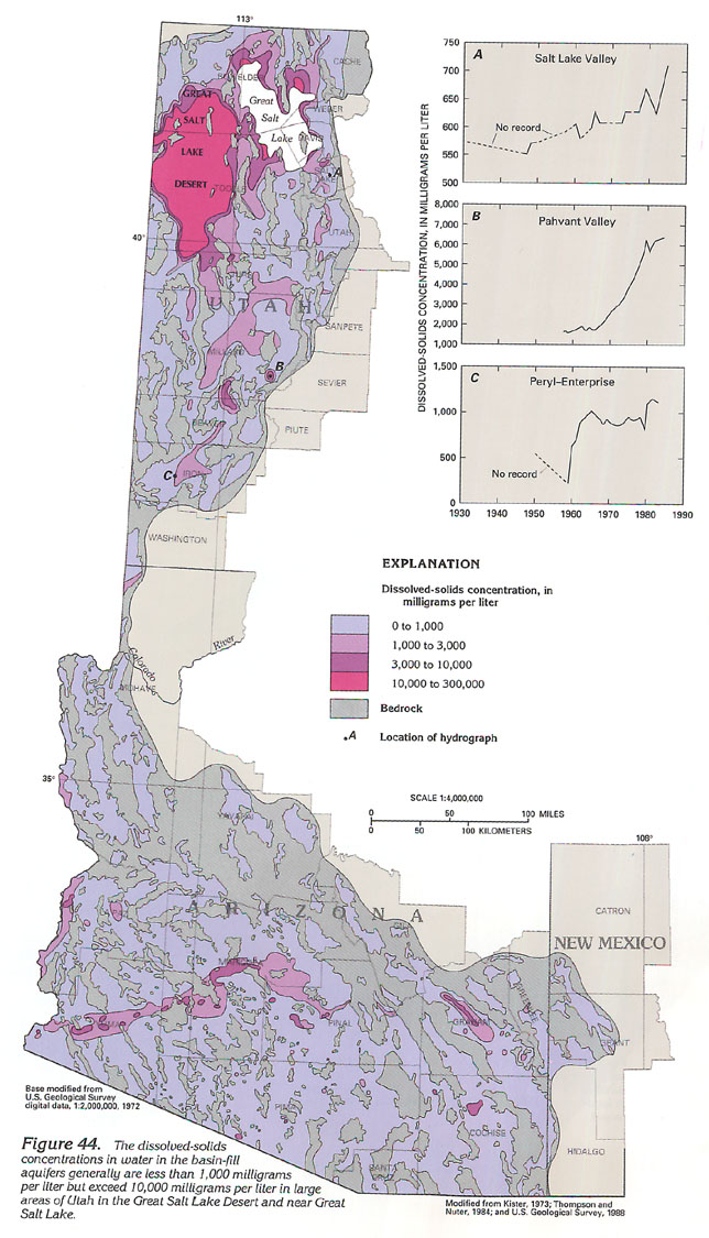
Ground water in the basin-fill aquifers generally is of suitable chemical quality for most uses; most ground water has a dissolved-solids concentration of less than 1,000 milligrams per liter. However, the dissolved-solids concentration of water in parts of some basins can be as large as 300,000 milligrams per liter (fig. 44). By comparison, the U.S. Environmental Protection Agency recommends that water for public supply not exceed 500 milligrams per liter of dissolved solids; seawater contains about 35,000 milligrams per liter of dissolved solids. Water that has small dissolved-solids concentration generally is present near the margins of the basins (fig. 44), where recharge from the nearby mountains enters the aquifers. In the topographically low parts of some basins, ground water is discharged by evaporation and transpiration. These processes remove some water from the aquifer and concentrate dissolved solids in the remaining water. If the volume of underflow or ground-water discharge to streamflow in the basin is relatively large, the accumulated salts are continually flushed from the basin, and the dissolved-solids concentrations in the aquifers are little affected. In basins that have less underflow or groundwater discharge to streamflow, or in basins where large volumes of irrigation water evaporate, salts may accumulate, and dissolved-solids concentrations in the ground water may range from 1,000 to more than 3,000 milligrams per liter. In basins that have no discharge by underflow or streamflow, salts can accumulate over long periods of time in the fine-grained sediments near the center of the basin, or can form extensive surface deposits of salt, such as the salt flats of the Great Salt Lake Desert in western Utah. Dissolved-solids concentrations in ground water near surface or subsurface deposits of saline minerals can be very large; concentrations commonly exceed 200,000 milligrams per liter in parts of western Utah.
Ground-water quality can be degraded by water use. Some of the irrigation water applied to fields carries dissolved salts, which have been concentrated by evapotranspiration, through the soil and to the water table, thus increasing the salinity of the ground water. If the irrigated fields are near a pumping well, the degraded ground water may again be withdrawn and applied to the field, thereby creating a cycle of water reuse that can progressively increase the salinity of the ground water. Other factors that may degrade ground-water quality include leaching of salts from the unsaturated zone, migration of mineralized ground water into the cone of depression around a well, and application of mineralized irrigation water obtained from other sources. Most irrigated areas underlain by a shallow water table have undergone water-quality degradation. In areas of greater depth to the water table, particularly in parts of Arizona, water-quality degradation might be minimal because recharge from irrigation might not have percolated to the water table.
Ground water in the basin-fill aquifers is of varied chemical composition. Near the recharge areas along the margins of most basins, the water generally contains a preponderance of calcium or magnesium cations and bicarbonate or sulfate anions, and thus is classified as a calcium magnesium, bicarbonate sulfate water type. Near the central part of many basins and near the Great Salt Lake Desert and Great Salt Lake in Utah, the water is a sodium chloride type.
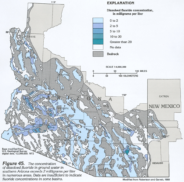
Concentrations of most dissolved constituents in ground water do not exceed U.S. Environmental Protection Agency Primary or Secondary Drinking Water Regulations. However, concentrations of dissolved fluoride are as much as 5 times greater than the Maximum Contaminant Level (4 milligrams per liter) for drinking-water supplies in parts of some basins in Arizona. Dissolved fluoride concentrations of more than 20 milligrams per liter are present in a few areas of Arizona (fig. 45). Smaller concentrations are measured in most parts of Arizona; concentrations in Utah generally are less than 2 milligrams per liter.
FRESH GROUND-WATER WITHDRAWALS
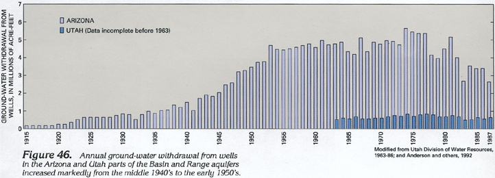
Ground-water withdrawal from wells is the largest component of discharge from the Basin and Range aquifers. In Arizona, for example, about 184,000,000 acre-feet of ground water was withdrawn from the basin-fill aquifers between 1915 and 1980 (fig. 46). In some extensively developed basins in Arizona, the rate of withdrawal is about 200 times the rate of recharge. About half the water withdrawn is lost to the atmosphere by evapotranspiration; the other half percolates through the soil and eventually returns to the aquifer as recharge. The evapotranspiration loss is called ground-water depletion. The 92,000,000 acre-feet of ground-water depletion in Arizona is about 10 percent of the original 900,000,000 acre-feet of ground water in storage.
Most ground water is withdrawn for irrigation of commercial crops. Withdrawal for irrigation began in the late 1800's when settlers realized that the water needed for their expanding agriculture exceeded the water available from surface-water sources. In Arizona, withdrawal was small until near the start of World War II when advances in pump technology, availability of inexpensive sources of electricity, and wartime demands combined to create a rapid increase in acreage irrigated by wells. Withdrawal has been less than 1,000,000 acre-feet per year in Utah from 1963 through 1987; withdrawal data are incomplete before 1963 (fig. 46). In Arizona, withdrawal has undergone a general decline since the late 1970's in response to use of more water-efficient irrigation systems, introduction of crops that use less water, and reduction in acreage irrigated by wells.
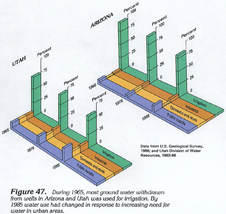
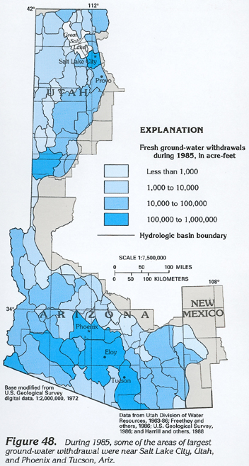
An increase in population has caused an increase in ground-water use in urban areas and the conversion of agricultural land to urban use. During 1965, about 93 percent of the ground water withdrawn in Arizona and about 72 percent of the ground water withdrawn in Utah was used for irrigation; by 1985, these percentages had decreased to about 80 percent in Arizona and 58 percent in Utah. During this 20-year period, ground-water withdrawal for public supply increased from less than 5 percent to more than 12 percent in Arizona and from less than 10 percent to more than 22 percent in Utah (fig. 47). Some of the largest rates of ground-water withdrawal are near the rapidly expanding metropolitan areas of Salt Lake City and Provo, Utah, and Phoenix and Tucson, Ariz. (fig. 48). Irrigation is still a principal water use in these areas, although populations of Tucson and many smaller communities in Arizona and Utah are increasing and ground water is the principal source of supply.
EFFECTS OF WITHDRAWALS
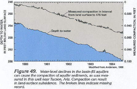
In Arizona, large water-level declines have caused land subsidence and earth fissures to develop in an area of about 3,000 square miles that includes parts of the two largest metropolitan areas-Phoenix and Tucson. Land subsidence primarily is caused by compaction of unconsolidated fine-grained sediments in the basin fill. These sediments deform and compact when water-level declines subject the sediments to additional compression from the weight of the overlying deposits; compaction increases slowly as the water levels decline (fig. 49). In basins that have undergone large water-level declines and have a large thickness of compressible fine-grained sediments, land subsidence has exceeded 15 feet since the start of ground-water development. Subsidence is less than 5 feet in most developed areas and is less than 1 foot in most of Arizona.
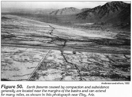
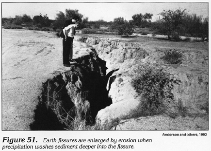
Compaction and land subsidence sometimes cause cracks (earth fissures) to develop in the land surface. Earth fissures can extend for hundreds to thousands of feet along the surface (fig. 50) and can be hundreds of feet deep. In a few instances, vertical offsets of as much as 3 feet at land surface have occurred across an earth fissure; however, most earth fissures seem to be simple tension breaks and show no vertical or lateral offset. Most fissures initially appear as cracks a fraction of an inch wide but gradually enlarge through erosion to form gullies that can be 10 feet wide and 10 feet deep (fig. 51). During rare periods of heavy precipitation, sediment is eroded from the sides of the fissure near land surface and is carried deeper into the fissure. The ultimate size of the eroded gully depends on the void space present in the deeper parts of the fissure.