TEXAS COASTAL UPLANDS AQUIFER SYSTEM
INTRODUCTION
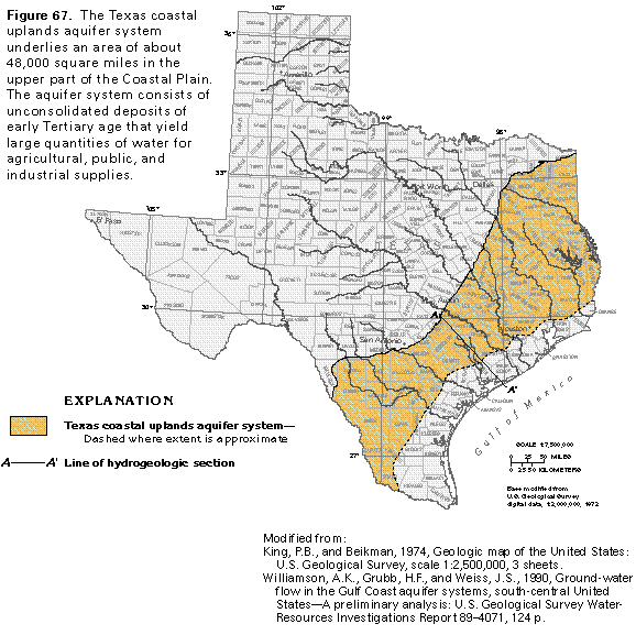
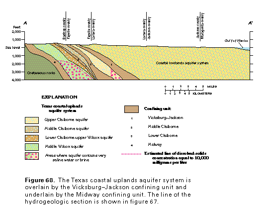
The Texas coastal uplands aquifer system consists of Eocene deposits of the Claiborne Group and Eocene and Paleocene deposits of the Wilcox Group. Both groups are below the Vicksburg-Jackson confining unit and above the Midway confining unit (figs. 67 and 68). East of the Texas-Arkansas and Texas-Louisiana State lines, stratigraphically equivalent beds are called the Mississippi Embayment aquifer system. The sediments that compose the Texas coastal uplands aquifer system dip coastward beneath the coastal lowlands aquifer system. The Texas coastal uplands aquifer system underlies an area of about 48,000 square miles in the Coastal Plain Physiographic Province and is in all or parts of 70 counties in Texas. The topography of the coastal uplands is more dissected and rolling than that of the coastal lowlands. Average annual precipitation in the uplands ranges from about 21 inches in the Rio Grande Valley to about 50 inches at the Louisiana border.
The Texas coastal uplands aquifer system furnishes large quantities of water for agricultural, public, and industrial needs. Water withdrawn for public supply generally contains dissolved-solids concentrations of less than 1,000 milligrams per liter. Slightly saline water with dissolved-solids concentrations that range from 1,000 to 3,000 milligrams per liter can be used for many agricultural and industrial purposes. Nearly one-half of all freshwater withdrawn from the Texas coastal uplands aquifer system during 1985 was pumped for agricultural use from Zavala, Frio, Atascosa, and Dimmit Counties in the west.
HYDROGEOLOGY
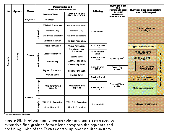
Deposits of the early Tertiary Claiborne and Wilcox Groups compose the Texas coastal uplands aquifer system (fig. 69). The sediments, in order of dominance, consist mostly of sand, silt, and clay and are distributed as relatively uniform sequences of predominantly fine- or coarse-grained material.
The Texas coastal uplands aquifer system is subdivided into four aquifers and two confining units. These are, from shallowest to deepest, the upper Claiborne aquifer; the middle Claiborne confining unit; the middle Claiborne aquifer; the lower Claiborne confining unit; the lower Claiborne-upper Wilcox aquifer; and the middle Wilcox aquifer. The widespread, intensively pumped lower Claiborne-upper Wilcox aquifer has been chosen to illustrate the aquifer system. Other aquifers in the system, though of lesser importance, show similar geometry, hydraulic characteristics, and water-quality trends.
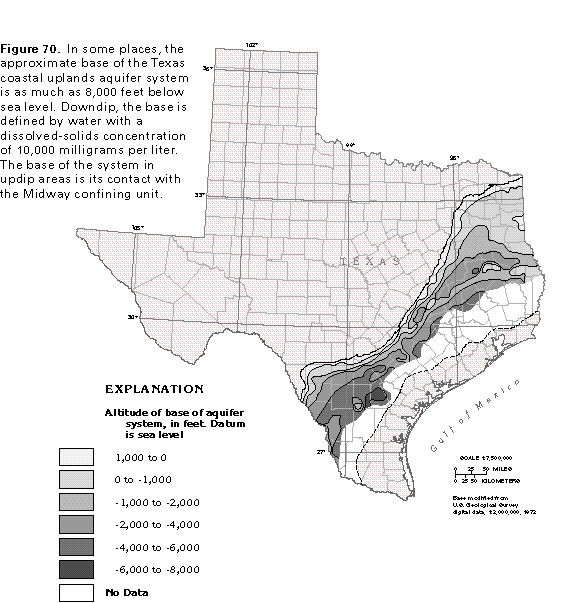
The landward boundary of the aquifer system is at the updip limit of the outcrop of the Wilcox Group. The Gulfward boundary is generally the farthest downdip extent of water in the aquifer system that has a dissolved-solids concentration of less than 10,000 milligrams per liter (fig. 68). The top of the aquifer system is either land surface or the base of the Vicksburg-Jackson confining unit. The base of the aquifer system is either its contact with the top of the Midway confining unit or the approximate depth at which the water in the system has a dissolved-solids concentration that exceeds 10,000 milligrams per liter. The altitude of the base of the aquifer system is shown in figure 70. The base ranges from less than 1,000 feet above sea level to nearly 8,000 feet below sea level. The thickness of the freshwater sands of the aquifer system ranges from 0 to nearly 3,000 feet (fig. 71).
LOWER CLAIBORNE-UPPER WILCOX AQUIFER
Ground-Water Hydraulics
Highly permeable sands that contain large volumes of freshwater over an extensive area make the lower Claiborne-upper Wilcox aquifer the most important aquifer in the Texas coastal uplands aquifer system. The lower Claiborne-upper Wilcox aquifer is recharged by the infiltration of precipitation that falls on topographically high aquifer outcrop areas. Natural discharge occurs as evapotranspiration, loss of water to streams in outcrop areas, and as upward leakage in downdip areas. Recharge and discharge are generally less than 1 inch per year in areas that have little or no pumpage. Water in the aquifer is generally unconfined in aquifer outcrop areas where the specific yield for the sandy deposits might range between 10 and 30 percent. Water is confined in downdip areas by the overlying lower Claiborne confining unit. In these areas, the storage coefficient of the aquifer is estimated to range between 1.0x10⁻⁴ and 1.5x10⁻³.
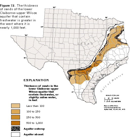
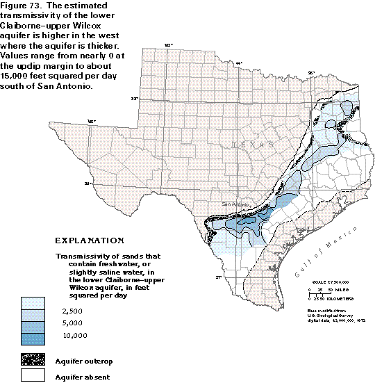
The thickness of the sands of the lower Claiborne-upper Wilcox aquifer that contain freshwater is shown in figure 72. Maximum sand thickness is nearly 1,000 feet in some western areas. Transmissivity for the aquifer, as estimated from a digital ground-water flow model, is shown in figure 73. Although the transmissivity is generally less than 5,000 feet squared per day, maximum values are nearly 15,000 feet squared per day in the west.
Ground-Water Quality
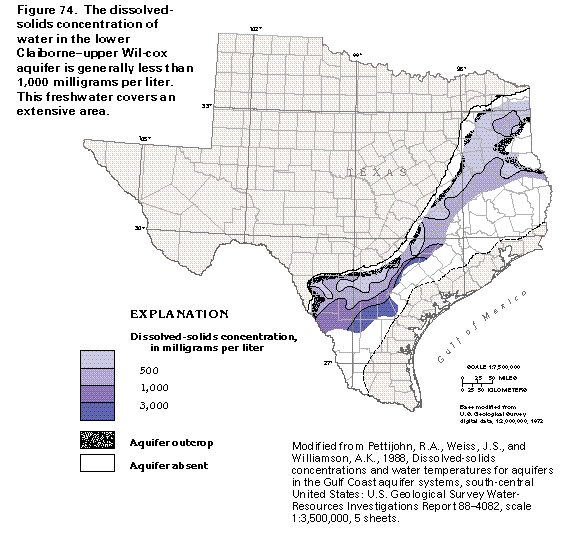
In extensive areas, the concentration of dissolved solids in water from the lower Claiborne-upper Wilcox aquifer is less than 500 milligrams per liter (fig. 74). The water is fresh (dissolved-solids concentrations less than 1,000 milligrams per liter) in nearly the entire eastern one-half of the aquifer and in most of the western one-half. Concentrations exceed 1,000 milligrams per liter in the central and western downdip areas.
Ground-Water Development
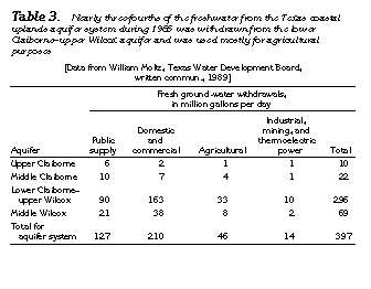
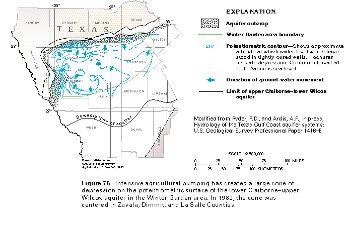
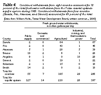
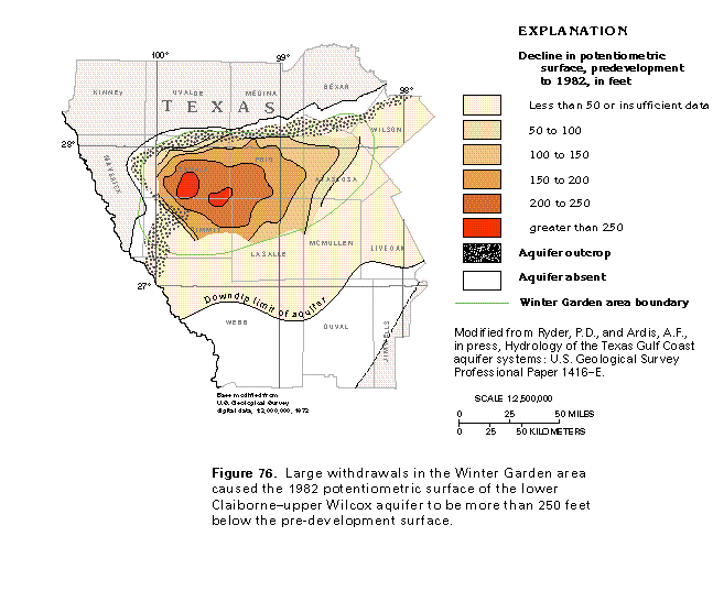
Withdrawals from the lower Claiborne-upper Wilcox aquifer during 1985 totaled 296 million gallons per day (table 3). This was nearly three-fourths of the total water withdrawn from the Texas coastal uplands aquifer system. Much of the water pumped from the lower Claiborne-upper Wilcox aquifer is used for irrigation in the agricultural Winter Garden area (fig. 75). This area is defined as all or major parts of Atascosa, Dimmit, Frio, La Salle, and Zavala Counties, and minor parts of Bexar, McMullen, and Wilson Counties. Combined withdrawals from Atascosa, Frio, Dimmit, and Zavala Counties accounted for nearly one-half of the water withdrawn from the Texas coastal uplands aquifer system during 1985 (table 4). The combination of infrequent killing frosts and fertile soils make the Winter Garden area ideal for growing garden vegetables and other food crops. Intense pumpage for irrigation in the Winter Garden area has created a large cone of depression on the potentiometric surface of the lower Claiborne-upper Wilcox aquifer (fig. 75). The lowering of the potentiometric surface from predevelop-ment conditions to 1982 was more than 250 feet in parts of Zavala, Dimmit, and Frio Counties (fig. 76). To sustain the large pumpage, recharge rates in parts of the outcrop are estimated to have increased by about 1 to 3 inches per year, and large amounts of water have been obtained from aquifer storage.
FRESH GROUND-WATER WITHDRAWALS
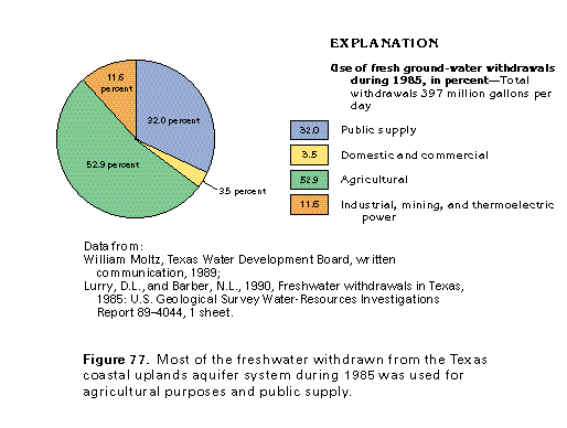
Withdrawals of freshwater, including some slightly saline water used predominantly for irrigation, from the Texas coastal uplands aquifer system totaled 397 million gallons per day during 1985 (fig. 77). Approximately 210 million gallons per day was withdrawn for agricultural purposes, the principal water use. About 127 million gallons per day was withdrawn for public supply and about 14 million gallons per day was withdrawn for domestic and commercial uses. About 46 million gallons per day was withdrawn for industrial, mining, and thermoelectric-power uses.
POTENTIAL FOR DEVELOPMENT
For the aquifers of the Texas coastal uplands aquifer system, the potential for development is greater in the east than the west, because precipitation and, thus, recharge potential is higher, and the extent of freshwater in the aquifers is greater. In some areas, particularly the Winter Garden area, the aquifers already are overdeveloped. In this area, the aquifers are being pumped in excess of recharge, and declining water levels are creating problems of excessive pumping lifts and migration of highly mineralized water into the pumped wells.
The Texas Water Development Board has made projections of ground-water use to 2030. For the eight counties that withdrew the largest amounts of water from the Texas coastal uplands aquifer system during 1985, the State projects a large decline in pumpage for seven counties and an increase in one county (table 5). Pumpage is predicted to decline from 36 to 83 percent below 1985 rates. For the combined eight counties, the total projected pumpage in 2030 is 59 percent less than the 1985 pumpage.