INTRODUCTION
The States of Arkansas, Louisiana, and Mississippi, which are located adjacent to each other and north of the Gulf of Mexico, compose Segment 5 of this Atlas. The three-State area encompasses an area of nearly 149,000 square miles. These States are drained by numerous rivers and streams, such as the Atchafalaya, the Teche, the Vermilion, the Calcasieu, the Mermentau, the Sabine, the Tombigbee, the Pascagoula, the Wolf, and the Pearl Rivers, that drain directly to the Gulf of Mexico. The Yazoo, the Big Black, the Arkansas, the St. Francis, the Red, and the White Rivers are tributaries of the Mississippi River, which is the largest of the rivers that drain the three States. Although surface water is the largest source of freshwater to public supply, domestic and commercial, industrial, mining, thermoelectric power and agricultural users, ground water also is important and accounts for 38 percent of total water use in Arkansas, Louisiana, and Mississippi.
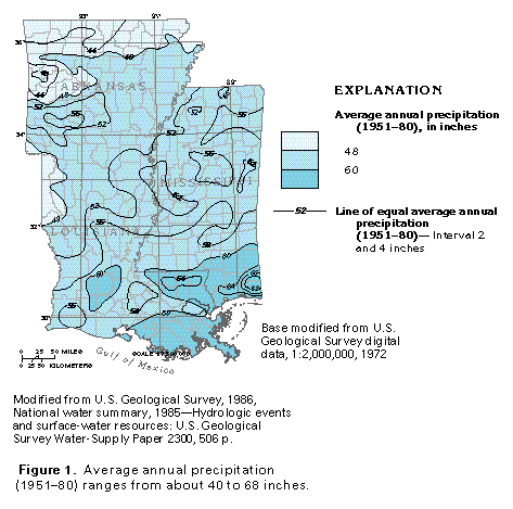
Precipitation is the ultimate source of water that recharges the ma-jor aquifers in Segment 5. Average annual rainfall (1951-80) amounts range from about 40 to about 68 inches (fig. 1). Temporal (seasonal) and spatial variations in precipitation are evident in the three-State area.
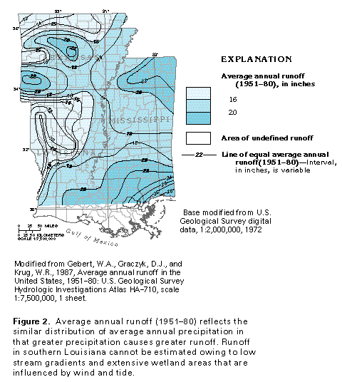
Average annual rainfall is greatest (60 inches per year or more) in southern Louisiana and southern Mississippi and diminishes in Arkansas and in northwestern Louisiana. Precipitation is greatest during January and May in Arkansas. May to September represent the wettest months in southeastern Louisiana and southern Mississippi. March and April are the wettest months in northern Mississippi. Average annual (1951-80) runoff ranges from less than 12 inches in western Louisiana and northwestern Arkansas to more than 20 inches in southern and northern Mississippi and in central and western Arkansas (fig. 2). Comparison of precipitation and runoff maps shows that less than one-half of the annual precipitation leaves the area as stream runoff. Much of the water that does not exit Segment 5 as runoff is returned to the atmosphere by evapotranspiration, which is the combination of transpiration by vegetation and evaporation from marshes, swamps, lakes and streams. A small amount of water recharges aquifers that are either exposed or buried to shallow depths, and an even smaller amount percolates downward and enters the deep flow system.
PHYSIOGRAPHY
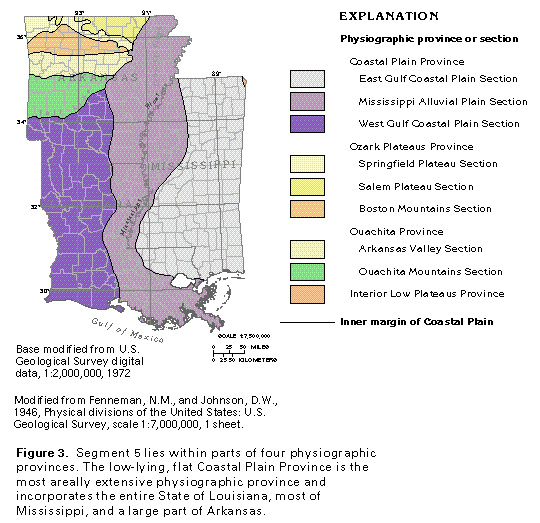
Segment 5 contains parts of four physiographic provinces-the Coastal Plain, the Ouachita, the Ozark Plateaus, and the Interior Low Plateaus (fig. 3). Uplands of the Ouachita and the Ozark Plateaus Provinces occupy the northwestern one-half of Arkansas. The Fall Line, a physiographic boundary that marks the inner margin of the Coastal Plain, separates the two provinces from the lowlands of the Coastal Plain Province. The Interior Low Plateaus Province is present in only a small part of the northeasternmost Mississippi and is discussed in Segment 6. The most extensively utilized aquifer systems of Segment 5 underlie the Coastal Plain Province.
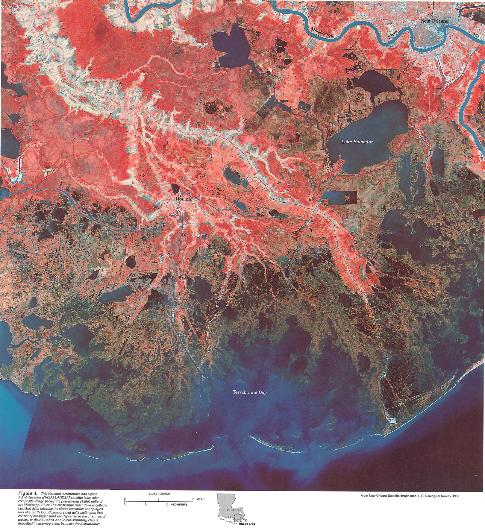
The Mississippi Alluvial Plain Section separates the eastern and western sections of the Gulf Coastal Plain Province. The Mississippi Alluvial Plain consists of a low flood plain and delta system that were formed by the Mississippi River. Crowley's Ridge, Arkansas, is the most prominent topographic feature within the Mississippi Alluvial Plain and is, in part, a north-south outlier of older, underlying Coastal Plain rocks. The southern portion of the ridge is covered with loess that is thought to have been deposited at the same time as the river terraces. The ridge cuts the northern part of the alluvial plain in half and is thought by some workers to have formed when the Mississippi and the Ohio Rivers flowed on opposite sides of the ridge. The Mississippi River captured the Ohio River along an upstream reach during late Pleistocene time, which reduced the river complex to one principal channel. Recent workers suggest Crowley's Ridge may be the result of Holocene fault movement. Although the Mississippi River is the principal river of the Mississippi Alluvial Plain Section, the Tensas, the Sunflower, and the Yazoo Rivers are among several other streams whose drainage basins are entirely or mostly contained within the alluvial plain. The distributary part of the Mississippi River system is in southern Louisiana. Deposition of sediments along and between distributaries has created a large delta, whose shape is best described as a bird-foot delta (fig. 4). The delta extends east-southeast and has built outward atop thick marine clay beds into the Gulf of Mexico. Thick sandy distributary channels are separated by interdistributary deposits of muds, thin muddy sands, and abundant organic deposits. The weight of the advancing delta front sand compacts thick underlying clays and forms depressions in which prograding channel sand or bar-finger sand facies are protected from erosion. As progradation continues, distributary channels extended further seaward, and the delta enlarges.
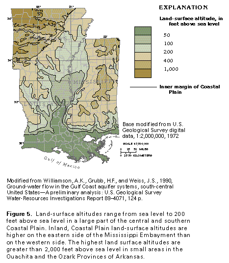
The altitude of most of the inland part of the Coastal Plain Province ranges from 300 to 600 feet above sea level in Mississippi and from 200 to 400 feet above sea level in Arkansas and Louisiana (fig. 5). A 10- to 150-mile wide coastal zone immediately adjacent to the Gulf of Mexico lies no more than 50 feet above sea level. The eastern part of the Gulf Coastal Plain Province (fig. 3) is characterized by a coastal plain of low hills, low cuesta ridges, and gentle lowlands. Fine-grained strata of clay, chalk, and mudstone underlie the low-lying areas; coarse sand and gravel underlie low ridges and hills. The western part of the province is a southward-facing plain of low, rolling, slightly hilly terrain that becomes a flat plain to the south. A broad marshy zone is near the coast.
The Ouachita Province in Arkansas is north of the West Gulf Coastal Plain Section and can be separated into the Ouachita Mountains Section to the south and Arkansas Valley Section to the north (fig. 3). The Ouachita Mountains Section is distinguished by valley and ridge topography. The ridges form straight to zigzag patterns and increase in height westward. Some ridges rise to more than 2,000 feet above sea level. North of the Ouachita Mountains Section, the Arkansas Valley Section forms a low-lying plain with low ridges oriented east to west. Although much of the Arkansas Valley Section generally is only 300 to 600 feet above sea level (fig. 5), the altitudes of several ridges range from 1,000 to more than 2,000 feet.
The Ozark Plateaus Province is north of the Ouachita Province and can be separated into the Boston Mountains Section to the south and the Springfield and the Salem Plateaus Sections to the north. The Springfield Plateau lies west and south of the Salem Plateau. The 200-mile long by 35-mile wide Boston Mountains Section is a deeply dissected plateau region that generally ranges from more than 1,900 to more than 2,500 feet above sea level and is characterized by flat-crested ridges that rise from 300 to more than 1,000 feet above V-shaped valleys. The surface of the Western Springfield Plateau, which is the intermediate level plateau, varies from gently rolling prairies to dissected terrain that ranges from 1,000 to 2,000 feet above sea level along its northern and southern margins. Topographic relief within this plateau area ranges from less than 100 feet in the prairie areas to more than 400 feet where streams have incised a north-facing escarpment that borders the Salem Plateau. In some areas of the Springfield Plateau, straight solution valleys intersect one another at 90-degree angles. The Salem Plateau, which is located east and north of the Springfield Plateau, lies at altitudes of 1,000 feet or less above sea level, but its land surface forms an irregular topography and is cut deeply by streams. However, topographic relief between hill crests and valley bottoms usually does not exceed 100 feet.
MAJOR AQUIFERS
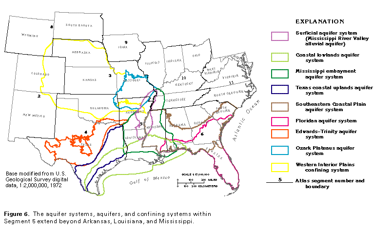
Major aquifers in Segment 5 are highly varied in composition, consolidation, and hydraulic character. The majority of Segment 5 aquifers consist of unconsolidated to poorly consolidated Coastal Plain strata of gravel, sand, clay, and minor limestone of Cretaceous to Holocene age. Other Segment 5 aquifers consist of indurated limestone, dolomite, shale, sandstone, chert, and novaculite of Paleozoic age that are either flatlying or gently to highly folded and contorted and that may be faulted and fractured. These aquifers are combined into eight aquifer systems, all of which extend beyond the Segment 5 study area (fig. 6). Only small parts of the Texas coastal uplands and the Floridan aquifer systems are in Segment 5; these aquifer systems are discussed in Chapters E and G of this Atlas, respectively.
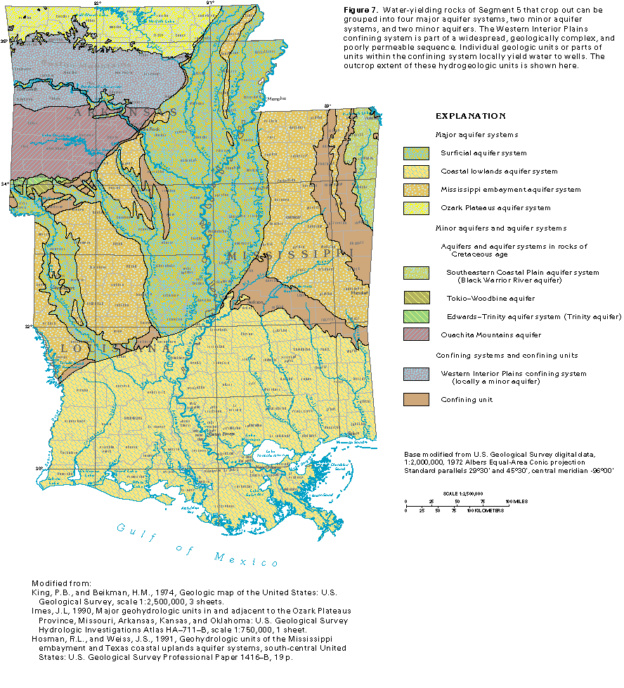
An aquifer system consists of two or more aquifers that are hydraulically connected. The aquifers may be separated, in places, by confining units, but there is regional hydraulic continuity within the system-the flow systems of the aquifers function similarly, and a change in conditions within one aquifer commonly affects the other aquifer(s). Likewise, confining units that may contain local aquifers, but which function together to retard the vertical movement of water, are called confining systems. The outcrop extent of the principal aquifers, aquifer systems, and a confining system in the Segment 5 study area is shown in figure 7.
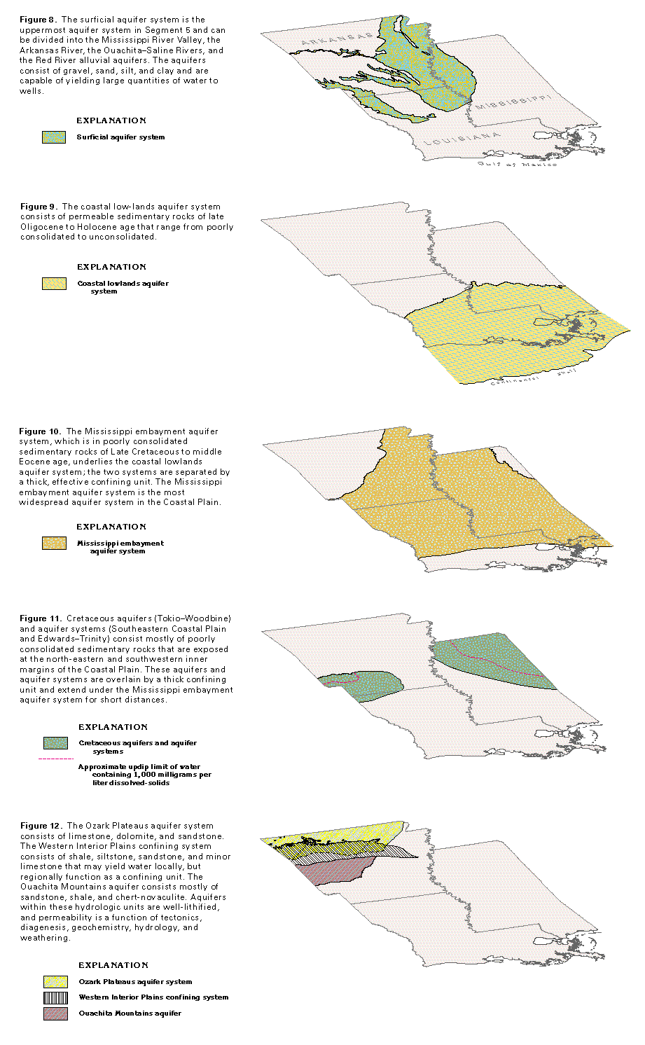
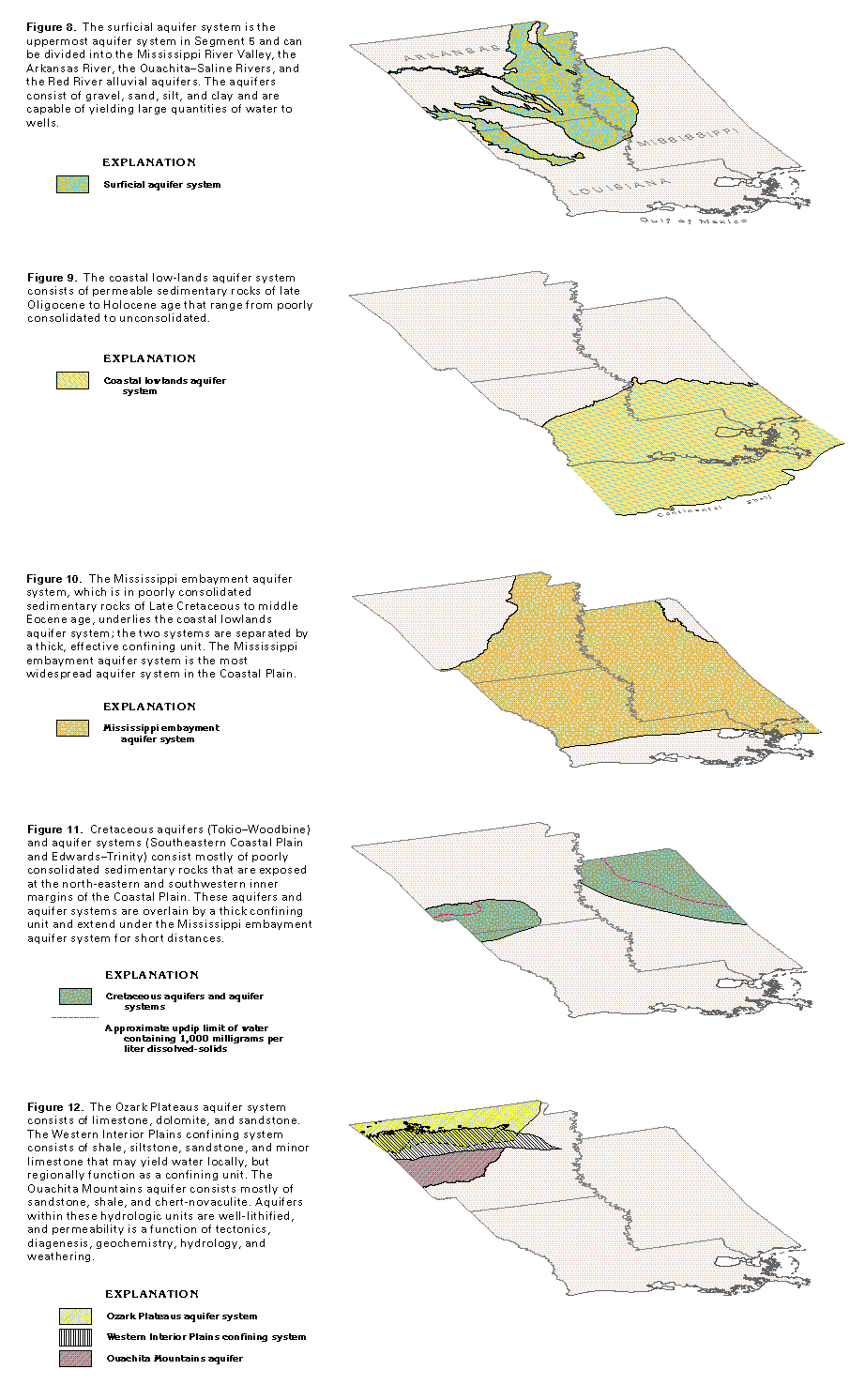
The surficial aquifer system consists of alluvial aquifers and includes one major and three minor aquifers (fig. 8). In terms of water use and areal extent, the most important aquifer is the highly productive Mississippi River Valley alluvial aquifer. The minor aquifers include the Arkansas River, the Ouachita-Saline Rivers, and the Red River alluvial aquifers. The Arkansas River alluvial aquifer is not as widespread as the other two aquifers, but locally is an important water source.
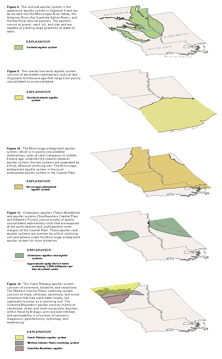
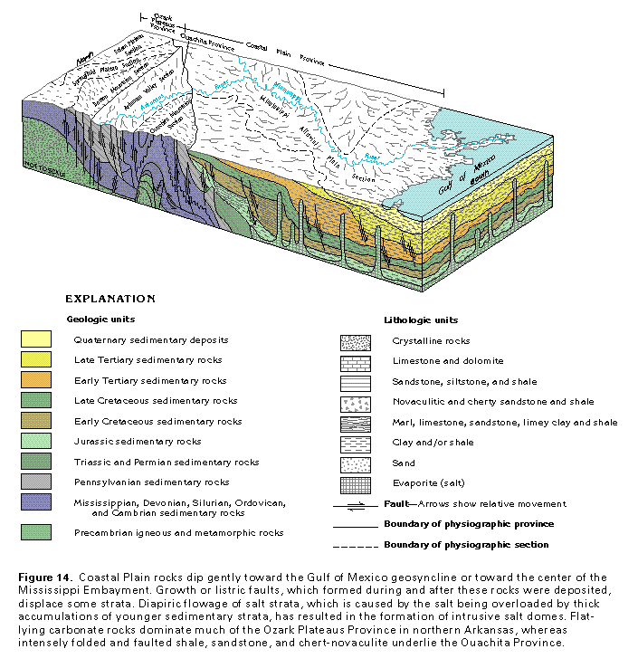
Parts of four Coastal Plain aquifer systems, the coastal lowlands (fig. 9), the Mississippi embayment (fig. 10), the Southeastern Coastal Plain (fig. 11), and the Edwards-Trinity, which are within rocks of Cretaceous to Quaternary age, are in the Segment 5 area. Coastal Plain rocks of Cretaceous age make up a locally important aquifer known as the Tokio-Woodbine aquifer. For purposes of this chapter, the Southeastern Coastal Plain and the Edwards-Trinity aquifer systems, and the Tokio-Woodbine aquifer are described in the section entitled, "Cretaceous Aquifers"; only parts of the aquifer systems are present (fig. 11). Aquifers and confining units within each of the four Coastal Plain aquifer systems thin landward to a featheredge and thicken with
depth as they extend toward the Gulf of Mexico into the deep subsurface. Most Segment 5 Coastal Plain aquifers contain freshwater downgradient well beyond the extent of their outcrop. All of the Coastal Plain aquifers and aquifer systems are comprised predominantly of poorly consolidated to unconsolidated clastic sedimentary rocks. The distribution and pattern of permeability within the different Coastal Plain aquifer systems are a function of lithology and primary porosity. In general, the most permeable Coastal Plain aquifers consist of sand and some gravel and are separated by silt, clay, marl, or chalk confining units. As these aquifers extend downdip, most grade to less permeable facies, such as clay or marl, that are part of adjoining confining units. A geopressured zone truncates the gulfward limit of aquifers within the coastal lowlands aquifer system.
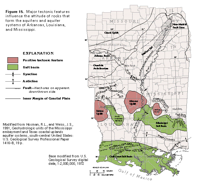
Flat-lying to southward-dipping limestone, dolomite, and sandstone comprise the principal aquifers of the Ozark Plateaus aquifer system (fig. 12). Permeability within this aquifer system is a function of regional and local tectonics, diagenesis, geochemistry, hydrology, and weathering.
The Western Interior Plains confining system underlies the rugged Boston Mountains and the rolling lowlands, synclinal mountains, and cuestas that characterize the northern flank of the Arkansas Valley. Although this confining system is poorly permeable, it contains sandstone, minor limestone, and highly jointed and fractured siltstone and shale that function as local aquifers. Geologic structure is a principal factor that controls the occurrence and movement of ground water within the unweathered part of the confining system. Another permeability control is associated with local faults, joints, and fractures. Ground-water movement within this system of secondary permeability depends on the intensity, aperture, orientation, connectivity, and filling of fracture systems.
Limited quantities of ground water can be obtained from sandstone, siltstone, shale, and chert-novaculite rocks of the Ouachita Mountains Section and the southern part of the Arkansas Valley Section. Primary porosity within the Paleozoic rocks of Segment 5 was destroyed by compaction during burial and structural deformation during uplift. Small amounts of ground water can be obtained from wells completed in rocks that contain joints and fractures or bedding planes.
GEOLOGY
Segment 5 is underlain by sedimentary rocks that range from unconsolidated to poorly consolidated clastic rocks in the Coastal Plain Province and alluvial areas to well-consolidated, flat-lying to southward-dipping fractured carbonate and clastic rocks in the Ozark Province to fractured, faulted, and folded shale, sandstone, limestone and chert-novaculite rocks in the Ouachita Province. Coastal Plain Province rocks are Mesozoic and Cenozoic (Jurassic to Quaternary) in age; rocks that underlie the Ozark and Ouachita Provinces are Paleozoic (Cambrian to Pennsylvanian) in age (figs. 13, 14).
The geologic and hydrogeologic nomenclature used in this report differs from State to State because of independent geologic interpretations and varied distribution and lithology of rock units. A fairly consistent nomenclature, however, can be derived from the most commonly used rock names. Therefore, the nomenclature used in this report is basically a synthesis of that used by the U.S. Geological Survey, the Arkansas Geological Commission, the Louisiana Geological Survey, and the Mississippi State Geological Survey. Individual sources for nomenclature are listed with each correlation chart prepared for this report.
Rocks of Ordovician to Pennsylvanian age underlie the outcrop areas of the Ozark Plateaus Province, and are, in turn, underlain by dolomite and sandstone beds of Cambrian age. The rocks of Cambrian age form the basal part of the Paleozoic sedimentary sequence, but are not exposed in northern
Arkansas. The Ozark Uplift is a structural high area that affects the attitude of Paleozoic rocks in northern Arkansas. In general, the rocks in northern Arkansas crop out as annular bands around the center of the Ozark Uplift, which is located in southern Missouri (fig. 15). Rocks of Ordovician to Mississippian age in the Ozark Plateaus Province that dip gently southward from northern Arkansas are dominated by shallow-water carbonate-shale sequences and contain some prograding deltaic sandstones, all of which were deposited on a cratonic shelf of Precambrian age. Sedimentary rocks that underlie the Boston Mountains Section consist mostly of Pennsylvanian sandstone and shale deposited in deltaic, open marine, coastal, and swamp environments.
Rocks that underlie the Ouachita Province consist mostly of a thick sequence of shale and sandstone that was deposited during Cambrian to early Pennsylvanian time within an elongate, subsiding Ouachita Trough. This trough formed by rifting along a late Precambrian-early Paleozoic continental margin. Down-to-the-south normal faulting and subsidence during Mississippian to Pennsylvanian time formed the shallower Arkoma Basin that lies north of the Ouachita Trough. Clastic, deep-water sediments were deposited within the Ouachita Trough and prograding deltaic, clastic shallow-marine, and some deep-marine deposits infilled the Arkoma Basin. Compressional tectonic forces closed the trough during late Pennsylvanian time and helped form the Ouachita Anticlinorium. The Ouachita Anticlinorium is an intensely fold-ed structure of plunging synclines, anticlines, and north- and
south-directed thrust faults; shale, chert, sandstone, conglomerate, novaculite, and volcanic tuff of this folded structure have been subject to widespread low-grade and low-temperature metamorphism. To the north, rocks of Pennsylvanian age within the Arkoma Basin were gently folded into an alternating series of synclines and anticlines in which anticlinal axes are separated by a distance from 5 to 8 miles. Normal faults are common in areas north of the Arkansas River, and thrust faults are present south of the river.
Postorogenic rocks of Permian and Triassic age rest un-conformably on the eroded Ouachita folded rocks but lie buried beneath Coastal Plain deposits in northern Louisiana. These strata largely consist of continental red-bed sedimentary deposits derived from the erosion of the Ouachita Mountains.
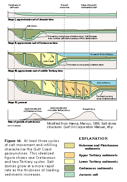
The oldest Coastal Plain rocks of Segment 5 are Jurassic in age and are deeply buried in the subsurface. A thick and extensive salt layer of Jurassic age composes the lower part of the Coastal Plain sequence in the Gulf Coast Basin (Stage I, fig. 16). Collapse and the gulfward diapiric flow of salt occurred during crustal downwarping and infilling of the Gulf Coast Basin (Stage II, fig. 16). Coastal Plain sedimentary rocks of Cretaceous age were deposited across a broad shelf. Major Cretaceous depositional facies shifted landward or gulfward during transgressive or regressive cycles that were controlled by eustatic sea-level change and differential rates of subsidence. Rocks of early Tertiary age and younger were deposited during progradational depositional cycles of alluvial and deltaic infilling within the Gulf Coast Basin (Stages III, IV, fig. 16).
Salt-dome basins are in southern Mississippi and central and southern Louisiana (fig. 15). Although few occur near the land surface, salt domes penetrate most or all of the Tertiary rocks at isolated locations. The domes are usually only 1 to 3 miles in diameter, and their effect on ground-water flow and water quality is localized.
The Mississippi Embayment is a large reentrant that forms a southward-plunging syncline, which greatly influences the outcrop pattern of Coastal Plain rocks in Segment 5. The embayment axis is closely aligned with the present-day (1997) location of the Mississippi River (fig. 15). Except where they are covered by Holocene alluvial deposits of the ancestral Mississippi River, Coastal Plain sedimentary rocks of Cretaceous to early Tertiary age crop out mostly in offlapping bands that parallel the perimeter of the embayment and dip gently toward its axis. Younger outcropping Coastal Plain sediments of late Eocene to Pliocene age do not extend as far north into the embayment as do older strata, but crop out as a belt that parallels the coastline, dipping gently southward into the Gulf Coast geosynclinal basin. Late Quaternary alluvial and deltaic deposits of the Mississippi River and its tributaries form a wide band that extends southward from the northern part of the embayment into the Gulf of Mexico. From a landward, outcropping featheredge, the entire Coastal Plain sequence thickens greatly toward the axis of the Mississippi Embayment and the Gulf Coast Geosyncline. The general gulfward thickening is interrupted by uplifts, domes, anticlines, basins, synclines, and faults of subregional size, some of which are shown in figure 15.
FRESH GROUND-WATER WITHDRAWALS
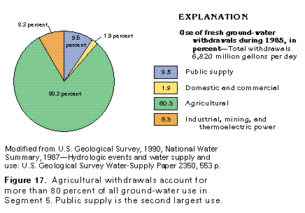
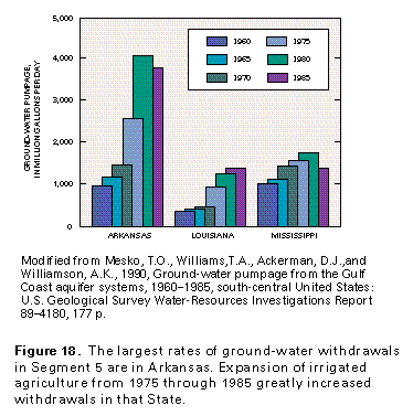
Ground water serves as an important source of water for many of the 9 million people that live in Arkansas, Louisiana, and Mississippi and supplies 38 percent of all water needed for public supply, agriculture, industry, mining, thermoelectric power, domestic, and commercial uses. About 6,800 million gallons per day of ground water were withdrawn in the three States of Segment 5 during 1985; about 80 percent of the ground water withdrawn is utilized by irrigated agriculture, mostly for growing rice, commercial vegetables, corn, and soybeans (fig. 17). The greatest increase in withdrawal rates occurred between 1970 and 1980, mostly within the Mississippi Alluvial Plain Section. In recent years, irrigation pumping has caused Arkansas to withdraw larger amounts of ground water than the other States of Segment 5 (fig. 18). Public supply represents the second largest user of ground water but accounts for less than 10 percent of the total water withdrawn. Ground water provides about 64 percent of the total freshwater withdrawn in Arkansas, about 68 percent of the freshwater used in Mississippi, and about 14 percent of the total freshwater withdrawn in Louisiana.
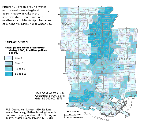
Total ground-water withdrawals, by county, during 1985 are shown in fig. 19. The largest withdrawals are in two major areas-the Mississippi Alluvial Plain in eastern Arkansas and northeastern Mississippi and a five-county area in southwestern Louisiana. Much of the ground water withdrawn is used for agricultural purposes, mostly irrigation of rice with smaller amounts for aquaculture (primarily catfish farming), both of which provide an important economic base for the three-State area.
Total ground-water withdrawals during 1985 from each of the major aquifers and aquifer systems are shown in fig. 20. The Mississippi River Valley alluvial aquifer and minor alluvial aquifers (the surficial aquifer system), which are the most heavily used, provide about 5.1 billion gallons per day of ground water or about 75 percent of all ground water used in Segment 5. Of this amount, about 5,050 million gallons per day was withdrawn from the Mississippi River Valley alluvial aquifer. The second most heavily used source of ground water is the coastal lowlands aquifer system, which provided nearly 1,150 million gallons per day, or 17 percent of all ground water used. The Mississippi embayment aquifer system provided about 6 percent of the total ground water withdrawn in the three-State area, whereas Cretaceous and Paleozoic aquifers provided only about 1 percent each of the total ground-water withdrawals.
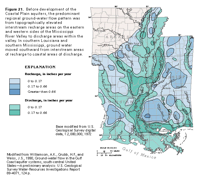
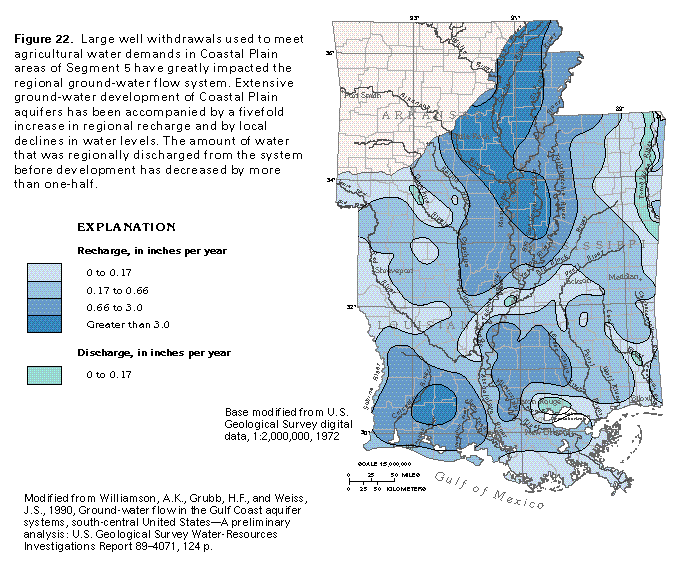
Withdrawals of large quantities of water from Coastal Plain aquifer systems during the last 90 years have lowered water levels, decreased the saturated thickness of several aquifers, caused encroachment of salt water, and even altered patterns of regional ground-water flow. Before development of the Coastal Plain aquifers, recharge entered the regional flow system in the upland, interstream areas between major rivers (fig. 21). Ground water was discharged in the valleys of the major rivers or along the coast. Recent regional investigations have shown that large, long-term withdrawals have caused an increase in the rate of recharge in some upland areas and that most of the major rivers no longer represent sites of regional ground-water discharge (fig. 22). Rather, because of extensive irrigation or the lowering of ground-water levels owing to pumpage near the rivers, most of the major river valleys have become recharge areas that provide water to the underlying Coastal Plain aquifers.