INTRODUCTION
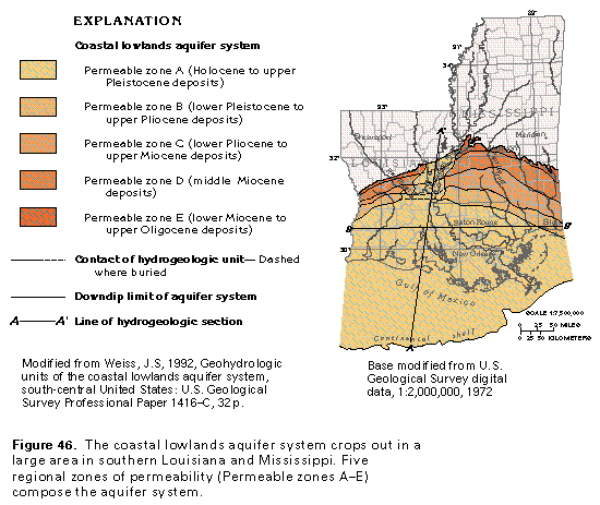
The coastal lowlands aquifer system consists of a gulf-ward-thickening, heterogeneous, unconsolidated to poorly consolidated wedge of discontinous beds of sand, silt, and clay that range in age from Oligocene to Holocene (fig. 46). The aquifer system underlies parts of the East and West Gulf Coastal Plain and the Mississippi Alluvial Plain Sections of the Coastal Plain Physiographic Province. The coastal lowlands aquifer system in Segment 5 extends eastward from Texas across southern and central Louisiana into southern Mississippi. The aquifer system extends westward and southwestward across Texas to the Rio Grande; this part of the system is described in Chapter E of this Atlas. A very small part of the system extends into southern Alabama and the western part of the Florida panhandle, where the system is called the sand and gravel aquifer; it is described in Chapter G of this Atlas. To the north, the uppermost unit of the system (Permeable zone A) merges with the Mississippi River Valley alluvial aquifer. The aquifer system extends to the edge of the continental shelf in the Gulf of Mexico, but it contains saline water in most of its offshore areas. Major rivers that flow across this aquifer system include the Mississippi, the Pearl, and the Red Rivers. Average annual precipitation ranges from 56 inches in western Louisiana to as much as 68 inches in southeastern Mississippi. The coastal lowlands aquifer system yields large quantities of water for agricultural, public supply, domestic and commercial, and industrial uses.
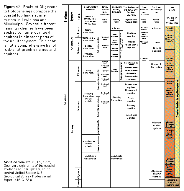
Permeable zones of the coastal lowlands aquifer system typically consist of interbedded sand and clay, rather than the massive, areally extensive sand beds common in other Coastal Plain aquifers and aquifer systems described in this Atlas segment. Numerous water-yielding and confining zones within the coastal lowlands aquifer system have been identified and mapped locally. Many local aquifer names have been applied to parts of the aquifer system primarily in Louisiana (fig. 47). The "Chicot aquifer" and the "Evangeline aquifer" are names commonly applied to the upper part of the coastal lowlands aquifer system in southwestern Louisiana. However, these aquifers do not extend into southeastern Louisiana as mappable hydrogeologic units. In the southeastern part of the State, therefore, an entirely different nomenclature is used for local aquifers; many of the aquifers in southeastern Louisiana have been named according to the depth at which they are usually encountered in the industrial districts of Baton Rouge and New Orleans, where ground-water pumpage is substantial (for example, the "1,200-foot" sand). Because of the regional southward dip of the aquifers and because they are cut and displaced by faults, the "1,200-foot" sand at New Orleans is not the same permeable unit as the "1,200-foot" sand at Baton Rouge. In this case, as in other cases, the same name has been applied locally to water-yielding strata that are neither stratigraphically equivalent nor hydraulically interconnected.
The diverse nature of the texture and thickness of the strata in the coastal lowlands aquifer system makes extension of local hydrogeologic units into a regional sequence extremely difficult. Lenticular sand and clay beds of the aquifer system have lateral and vertical boundaries that are gradational, poorly constrained, and difficult to trace over more area than a few counties or parishes. Some water-yielding zones and local aquifers have been distinguished solely on the basis of local differences in hydraulic head or hydraulic conductivity. In many cases, such distinguishing characteristics are important only locally. The aquifer system composes mostly deltaic and associated marginal marine deposits in which changes in lithologic facies are rapid, numerous, and complex. Intrastate and interstate correlation, even with the aid of geophysical well logs and paleontologic information, usually is extremely tenuous. Correlation is further complicated by the presence of numerous growth faults that vertically displace the hydrogeologic units and by the lack of widespread marker horizons or continuous clay beds. The lack of widespread clay beds means that few continuous confining units can be used to divide the section into the customary sequence of alternating aquifers and confining units. Despite all these difficulties, intensive studies have indicated that the aquifer system can be divided into five permeable zones of regional extent (fig. 47).
THICKNESS AND EXTENT
From a landward featheredge, sediments that compose the coastal lowlands aquifer system extend and thicken coastward or toward the axis of the Mississippi Embayment. The oldest sediments of the aquifer system are exposed farthest inland, with belts of progressively younger sediments exposed coastward in an offlap relation. A notable exception are the youngest sediments that compose the aquifer system's uppermost water-yielding unit, Permeable zone A. This zone locally overlaps older strata where it extends northward and merges with the Mississippi River Valley alluvial aquifer.
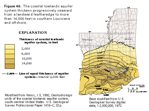
The thickness of the coastal lowlands aquifer system is greatest in southern Louisiana and adjoining offshore areas where the aquifer system is more than 14,000 feet thick (fig. 48). The thickness of the aquifer system and its downdip, gulfward extent are determined, in part, by progressive facies change as permeable deltaic sands grade seaward to less permeable prodelta silt and clay. These prodelta sediments are fine-grained terrigenous clastics deposited from suspension seaward of the delta front. The coastal lowlands aquifer system consists largely of sediments deposited in a deltaic to marginal marine environment. The aquifer system, therefore, contains a highly interbedded mix of sand and clay. Thick sand beds of wide areal extent are uncommon.
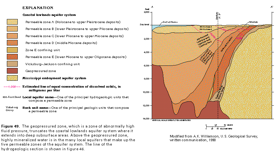
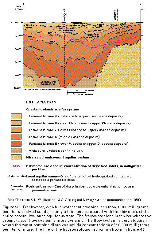
A second factor that determines the gulfward extent and thickness of the coastal lowlands aquifer system is the depth to the top of the geopressured zone (figs. 49, 50). In deep subsurface areas of southern Louisiana, southern Mississippi, and the Gulf of Mexico, the coastal lowlands aquifer system is truncated downdip by the geopressured zone, which is a zone of abnormally high fluid pressures that lies at depths that usually range from more than 5,000 to 13,000 feet in southern Louisiana. Under normal rates of sedimentation, water called formation water is trapped between sediment grains but is expelled when the sediments compact as they are slowly buried by younger sediments. The geopressured zone, however, contains formation water that was trapped in the sediments under conditions of very rapid burial and sediment compaction; the buried sediments remain undercompacted and the formation water is under great pressure. Extensive growth faulting in southern Louisiana also contributed to formation of the geopressured zone. The faults isolated and hydraulically cut off beds into sealed compartments. These faults eliminated the opportunity for pressured pore water to dissipate as sediments were more deeply buried. Movement of water within the geopressured zone is extremely slow and a small volume of geopressured water moves upward toward the meteoric flow system, but the amount is minuscule relative to the quantity of water that circulates within the coastal lowlands aquifer system. The geopressured water moves only into deeply buried parts of the aquifer system that contain highly mineralized water.
HYDROGEOLOGIC UNITS
Recent studies have separated the coastal lowlands aquifer system into five zones of permeability as part of a regional assessment of ground-water conditions in coastal Texas, southern Louisiana, and southern Mississippi. The equivalency of the five permeable zones with local aquifers is shown in figure 48. Owing to the difficulty of making stratigraphic and hydrogeologic correlations within the coastal lowlands aquifer system and to the general absence of widespread confining units, a set of hydrologic criteria is used to delineate and map the regional permeable zones. A comparison of conditions in the permeable zones indicates that large contrasts in hydraulic head increase with depth and that differences in hydraulic conductivity between different zones are large. Where such differences are not readily observable, separation of the permeable zones tends to be arbitrary. Although the five zones are called permeable zones because they are difficult to define precisely, they can be considered to be regional aquifers because of their wide extent and great thickness. All the zones consist of unconsolidated to poorly consolidated beds of sand and clay.
In the deep subsurface of southern Louisiana and offshore areas near southwestern Louisiana, the deltaic sediments of the coastal lowlands aquifer system grade to a marine sequence that contains two extensive clay beds. These clay beds were used to separate and map regionally the two lowermost permeable zones of the coastal lowlands aquifer system. A widespread, effective confining unit underlies the coastal lowlands aquifer system throughout its extent in Louisiana and Mississippi (figs. 49, 50). This confining unit, known as the Vicksburg-Jackson confining unit, separates the coastal lowlands aquifer system from the underlying Mississippi embayment aquifer system.
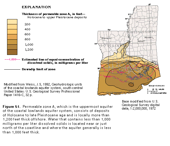
Permeable zone A consists of deposits of Holocene to late Pleistocene age. Because it is widespread and contains freshwater in most places, it is the most intensively pumped aquifer of the system, and, for this reason, it is the only zone for which the hydrogeology is described in this report in detail. Permeable zone A is thickest in southern Louisiana where its thickness is greater than 1,000 feet near the coast (fig. 51). In northeastern Louisiana, it merges with the Mississippi River Valley alluvial aquifer. Alluvial deposits of the Mississippi River Valley that overlie Permeable zones B through E of the coastal lowlands aquifer system are not considered to be part of the Mississippi River Valley alluvial aquifer because those deposits are hydraulically well connected to the wide, coast-parallel band of Holocene and upper Pleistocene deposits in southern Louisiana and southwestern Mississippi that makes up the main body of Permeable zone A.
Permeable zone B, which comprises deposits of early Pleistocene to late Pliocene age, underlies zone A. The two zones are not separated by an intervening confining unit; separation of the two aquifers is based solely on differences in vertical hydraulic gradient and hydraulic conductivity. The part of Permeable zone B that contains freshwater generally is less than 1,000 feet thick. Freshwater parts of the aquifer in the southern Mississippi and central Louisiana subsurface generally are at depths of more than 500 feet below sea level. In eastern Louisiana, the aquifer may contain freshwater at depths from 600 to 700 feet below sea level. Permeable zone B is the second most intensively pumped aquifer of the coastal lowlands aquifer system; most withdrawals from the zone are concentrated in the Baton Rouge industrial area.
Permeable zone C consists of deposits of early Pliocene to late Miocene age, Permeable zone D comprises deposits of middle Miocene age, and Permeable zone E consists of deposits of early Miocene to late Oligocene age. Permeable zones C, D, and E crop out as narrow bands that extend across central Louisiana and southern Mississippi and thicken in the subsurface as they extend coastward (fig. 50). Each aquifer is truncated at its southernmost extent by the geopressured zone. In the coastal areas of Louisiana and adjacent offshore areas, a deeply buried confining zone separates Permeable zones D and E. Offshore from southwestern Louisiana, a second confining unit separates Permeable zones C and D. These confining zones pinch out, or grade by facies change to more permeable strata, as they extend updip into the shallower subsurface. For the most part, however, the confining units separate only the parts of Permeable zones C, D, and E that contain saline water or brine. The freshwater lens contained within Permeable zones C, D, and E generally is less than 2,000 feet thick and lies at depths that are shallower than 2,000 feet below sea level.
RELATION BETWEEN GEOLOGY AND PERMEABILITY
Understanding the physical framework of the clastic lithofacies of the aquifers of the coastal lowlands aquifer system is useful in predicting the hydraulic characteristics of the aquifers. Hydraulic and lithofacies data can be compared to help understand lateral heterogeneity within the aquifer system. Lithofacies maps provide valuable insight into the distribution of permeability in clastic Coastal Plain aquifers, especially where hydraulic data are limited, and can be used as a predictive tool in the search for previously overlooked or unex-plored sites suitable for development of ground-water resources.
In an aquifer that comprises clastic sediments, the hydraulic conductivity of the aquifer is directly influenced by particle size and shape, the degree of particle packing and sorting, the amount of clay or fine-grained material that fills intergranular pore spaces, and cementation of the sediments. To a large degree, these factors are influenced by the depositional history of the rock. In southern Louisiana, the compaction of sediments that follows their burial results in a systematic loss in the porosity of sand beds that averages 1.28 percent per 1,000 feet of burial depth. The reduction in porosity of clay beds as a result of burial is much greater and averages 20 percent per 1,000 feet of burial depth. The hydraulic conductivity of the unconsolidated to poorly consolidated sediments that compose Coastal Plain aquifers does not appear to be greatly altered by diagenesis and geochemical processes. The distribution of hydraulic conductivity in Coastal Plain aquifer, therefore, can be estimated from maps of lithofacies, because the correlation between sediment type and aquifer permeability is direct.
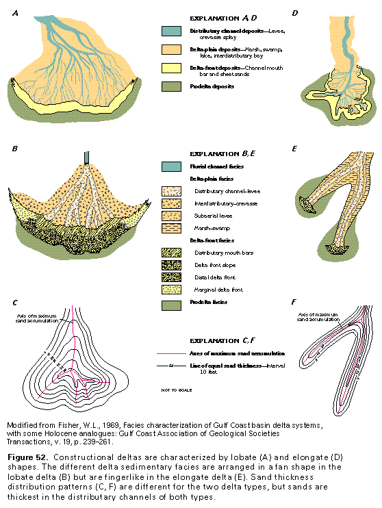
Sediments that compose the coastal lowlands aquifer sys-tem were, for the most part, transported by rivers and streams that flowed coastward and were deposited in deltaic environments. For the most part, sufficient quantities of fluvially transported sand, silt, and clay were deposited in subaerial and subaqueous environments near the coast at a rate that exceeded removal of the sediments by wave action and longshore currents. As a result, constructional deltas prograded or built outward into the Gulf of Mexico, primarily from the mouth of the Mississippi River.
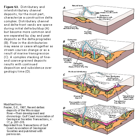
Constructional deltas are characterized by either distributaries with a lobate (fan) shape (fig. 52A) or an elongate (bird-foot) shape (fig. 52D). Lobate and elongate distributaries have sand deposits in the distributary channels and as arcuate accumulations at the delta front, where the sand settles out of suspension when the river water confined in the distributary loses velocity as it enters deeper water (fig. 53). Fine-grained deposits of silt and clay accumulate as interdistributary bay, swamp and marsh deposits within the delta plain as prodelta clays are deposited seaward of the delta-front sands.
Delta-plain and delta-front facies show a complex distribution associated with lobe (fig. 52B) and elongate (fig. 52E) distributary patterns. The branching of lobate distributaries resembles the splayed fingers of a human hand, and these distributaries tend to build a fan-shaped delta outward into the Gulf of Mexico. In the lobate delta front, the coarsest sands are in the distributary mouth bars; grain size diminishes seaward through the delta-front slope, with only silt and clay deposited within the prodelta area. Delta-front deposits are a mixture of clay, silt, and fine to coarse sand and accumulate mostly under the influence of currents and wave action. On the lobate delta plain, coarse-grained deposits are in distributary channels and adjacent levees, whereas interdistributary deposits are fine grained. Lower delta-plain distributary channel sands tend to be restricted in lateral extent, thus forming straight, narrow channels. Upper delta-plain point-bar sands form disconnected, linear, lenticular sand bodies that show evidence of lateral migration by meandering. Sandy crevasse-splay deposits are located in the lower part of the delta plain where low-lying levees are easily breached; sand accumulates as a small fan or delta as floodwaters flow over the levee into the inter-distributary areas. Silt and clay are the principal sediment types of interdistributary bay, marsh, and swamp environments; these sites areally compose the largest part of the lower delta plain. The delta-front facies is small in an elongate delta compared with a lobate delta. The delta-plain facies parallel elongate distributary channels and are more complex than the facies of a lobate delta but show a banded pattern of sediment that is progressively finer with increasing distance from the distributary channel.
Sand accumulations along lobate (fig. 52C) and elongate (fig. 52F) distributaries reflect the general shape of the distributary. In both types of distributaries, the axis of maximum sand thickness is located at the distributary channel. Sand thickness decreases in all directions away from the channel. An important factor that controls the type of constructional delta that forms is the thickness of the underlying clay beds. Elongate deltas tend to overlie thick prodelta clay deposits that subside and compact in response to sediment loading, thus helping preserve the distributary channels. Lobate deltas tend to overlie thinner prodelta clays that do not afford great differential subsidence; distributary channels are more numerous and thinner. Lobate and elongate (bird-foot) distributary channel facies are reported in buried sedimentary strata of the coastal lowlands aquifer system.
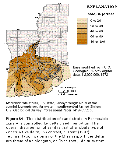
The overall distribution of sand within Permeable zone A (fig. 54) is similar to that of a lobate, rather than an elongate, delta system. Although some parts of the zone are characterized by sand concentrations as high as 100 percent that extend as narrow sand bodies, the zone comprises a series of small delta lobes that are combined as a single hydrogeologic unit. Locally, some areas contain concentrated sand bodies that may be part of small elongate deltas. These elongate sand bodies are located offshore and possibly reflect areas where distributary channels have prograded over thicker prodelta clays. Interdistributary deposits contain only 20 to 60 percent sand; they comprise mostly silt, clay, and lignite and were deposited between distributary channel sands. Distributary and interdistributary lithofacies grade gulfward to prodelta silt and mud that contain less than 20 percent sand.
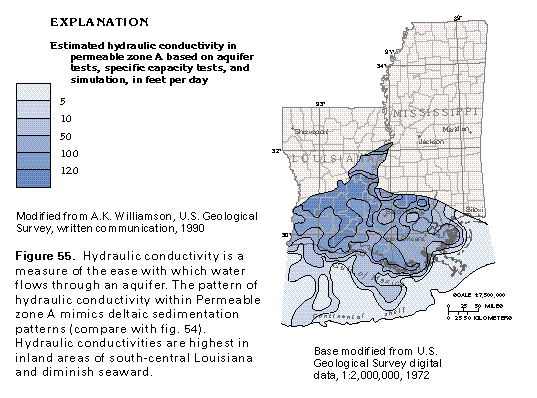
A hydraulic conductivity map of Permeable zone A was constructed by using aquifer and specific-capacity test data, as well as trial-and-error estimates of permeability obtained from computer simulation of the regional ground-water flow system. Areas of moderately high (from 100 to greater than 120 feet per day) hydraulic conductivity (fig. 55) compare well with the location of high sand percentages within the zone (fig. 54). Interbedded silt, mud, lignite and very fine sand probably account for the less permeable nature of possible distributary channel sands in more coastward areas. Areas of less than 10 percent sand with a hydraulic conductivity of less than 5 feet per day are associated with probable prodelta areas. Interdistributary deposits are poorly permeable (hydraulic conductivity from 5 to 100 feet per day) but are more permeable than prodelta deposits.
GROUND-WATER FLOW
Under natural conditions, precipitation entered the coastal lowlands aquifer system in mostly landward, interstream areas. Owing to the gravity-driven nature of the ground-water flow system, topography greatly influences the areas most likely to be sites of recharge and discharge, as well as the rate and direction of ground-water flow. Under natural conditions, recharge to the coastal lowlands aquifer system was greatest in the topographically high areas east and west of the Mississippi River and along the landward margin of the aquifer (fig. 56). Regional ground-water flow was directed southward to the coast with ground water discharged by diffuse upward leakage to major rivers, low-lying coastal marsh areas, and to the ocean as seabed seepage in shallow nearshore areas.
Although Permeable zone A is not overlain by a regional confining unit, ground water is contained within the deeper parts of the zone under confined conditions. This is due to abundant, but discontinuous, fine-grained beds of local extent that act as confining units, but cannot be traced over an area larger than several counties. Because these local confining units combine to retard the vertical movement of ground water, water in the aquifer at depths of a few hundreds of feet is under confined conditions in most locations.
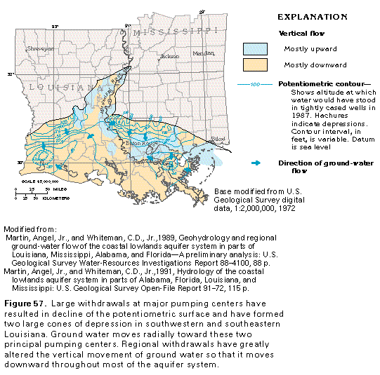
More than 90 years of increasingly large withdrawals of water from the coastal lowlands aquifer system in southwestern and southeastern Louisiana, primarily for agricultural and municipal uses, has greatly altered the ground-water flow system. Large ground-water withdrawals from Permeable zone A have resulted in water-level declines and large cones of depression (fig. 57). The greatest water-level declines in this zone are in southwestern Louisiana and in the New Orleans area. Water-level decline has resulted in a considerable change in horizontal and vertical components of ground-water flow. Near pumping centers, the current (1987) direction of ground-water flow was in places opposite to natural or predevelopment direction. Large withdrawals also have induced greater infiltration of precipitation at aquifer outcrop areas and greater streambed leakage. The areal extent of discharge areas (compare figs. 56 and 57) has correspondingly decreased. Large withdrawals have caused similar large declines in water levels in Permeable zone B in the Baton Rouge area.
GROUND-WATER QUALITY
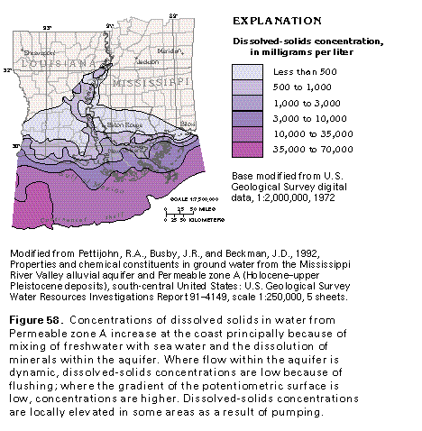
Dissolved-solids concentrations of water in the coastal lowlands aquifer system are directly related to ground-water flow in the system. In updip areas where the aquifers are recharged, ground water has small concentrations of dissolved solids, but the water becomes increasingly saline as it moves toward the coast. Several factors contribute to the coastward increase in dissolved-solids concentration. Dissolved solids increase, in part, as a result of dissolution of aquifer minerals. Water that approaches the coastline becomes even more mineralized as a result of mixing with sea water. Ground-water movement near the coast is sluggish and may not be sufficient to flush saltwater from the aquifer.
Permeable zone A contains fresh or slightly saline water nearly to the coast in most areas (fig. 58). A band of water that contains dissolved-solids concentrations from 500 to 1,000 milligrams per liter parallels the Atchafalaya River. In coastal areas of Louisiana, the zone contains water with dissolved-solids concentrations of more than 1,000 milligrams per liter.
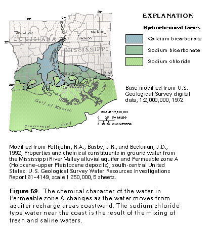
Water in aquifer recharge areas of Permeable zone A is primarily a calcium bicarbonate type (fig. 59). As the water moves downgradient, it becomes a sodium bicarbonate type because calcium ions are exchanged for sodium ions in aquifer minerals, primarily clay minerals. A sodium chloride hydro-chemical facies near the coast is in an area that corresponds to the gulfward increase in dissolved solids and mixing with saline water (fig. 59).
FRESH GROUND-WATER WITH-DRAWALS AND DECLINE OF WATER LEVELS
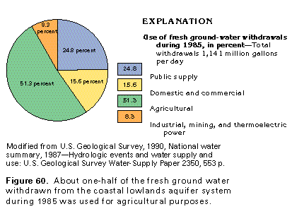
The coastal lowlands aquifer system is the second most important source of ground water in Segment 5. During 1985, about 1,140 million gallons per day of fresh ground water was withdrawn from the aquifer system for all uses (fig. 60). Withdrawals for agricultural use accounted for more than 51 percent of the total withdrawals from the aquifer system, or about 585 million gallons per day. About 25 percent, or about 283 million gallons per day, of the total withdrawals were used for public supply purposes. Domestic and commercial users withdrew about 178 million gallons per day, nearly 16 percent of the total withdrawals. Industrial, mining and thermoelectric power withdrawals were about 95 million gallons per day, or about 8 percent of the total withdrawals.
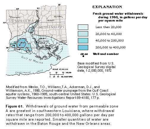
Most ground-water withdrawals from the coastal lowlands aquifer system are concentrated in New Orleans, Baton Rouge, and southwestern Louisiana (fig. 61). Of the five aquifers in the coastal lowlands aquifer system, Permeable zone A has the largest withdrawals. However, ground-water withdrawals from the Baton Rouge pumping center have been mostly from Permeable zones B and C with smaller amounts from Permeable zone D. Withdrawals in New Orleans and Baton Rouge are primarily for industrial purposes. Agricultural withdrawals from Permeable zone A in southwestern Louisiana are mostly for irrigation of rice.
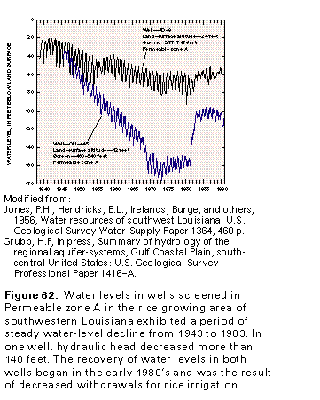
Several hundred wells were constructed in Permeable zone A before 1903 to provide water for rice irrigation in southwestern Louisiana. Ground-water withdrawals in this area increased from about 280 to about 800 million gallons per day between 1947 and 1980. In figure 62, hydrographs of two wells in southwestern Louisiana completed in the zone show a steady decline in water levels from 1943 to 1983. Hydraulic heads declined during this period by almost 150 feet near the center of intense pumping and about 75 feet at a more distant location (fig. 62). A decrease in total withdrawals caused a rise in water levels between 1983 and 1990.
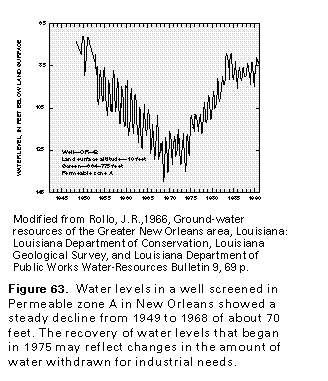
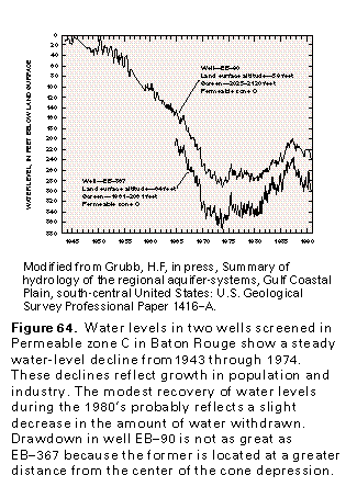
Withdrawals primarily for industrial uses and smaller withdrawals for public supply are concentrated in Baton Rouge and New Orleans. In New Orleans, ground-water withdrawals of about 5 million gallons per day from Permeable zone A in 1900 increased to approximately 55 million gallons per day in 1970. Water levels declined steadily from 1950 to 1970, as shown in figure 63. Industrial activities changed, however, and smaller quantities of ground water were withdrawn from 1970 through 1985. This decrease in pumpage was followed by a steady period of recovery, and water levels rose to within 10 feet of the 1950 levels. In the Baton Rouge area, estimated withdrawals of 2 million gallons per day in 1900 increased steadily until 1970 when shallow water-yielding strata (Permeable zone A) were abandoned in favor of deeper zones as withdrawal rates increased. Between 1970 and 1990, withdrawal rates ranged from 120 to 150 million gallons per day. Wells completed in Permeable zones C and D in the Baton Rouge area withdraw smaller volumes of water; in figure 64, hydrographs of two wells screened in Permeable zone C show a steady decline in water levels until 1974. Both wells are located near a heavily pumped industrial district in which 1990 withdrawals were estimated to be 20 million gallons per day. The difference in water levels of the two wells is attributed to their proximity to the center of a large cone of depression that surrounds the industrial district; well EB-90 is located at a greater distance from the center of the depression than well EB-367. The recovery of water levels in Permeable zone C that began in the early 1980's may reflect changes in the amount of water withdrawn for industrial needs.
WELL YIELD
The coastal lowlands aquifer system is capable of yielding large quantities of water to properly constructed wells. Large-capacity industrial and municipal wells have been reported to flow as much as 4,000 gallons per day when they are first drilled. Many large-capacity wells screened opposite water-bearing sands of Permeable zones A through D typically yield more than 1,000 gallons per minute. The uppermost part of Permeable zone A is apparently less productive than its lower part. Many wells completed in the upper part yield less than 1,000 gallons per minute; shallow sands commonly yield less than 500 gallons per minute. Conversely, wells completed in the lower part of Permeable zone A characteristically yield more than 1,000 gallons per minute; the greatest reported yield of large industrial wells is 3,000 gallons per minute. Wells screened opposite water-bearing sands of Permeable zone B in southwestern Louisiana yield from 100 to more than 2,000 gallons per minute, whereas industrial wells completed in the same zone located in Baton Rouge have a reported average yield of 830 gallons per minute. Permeable zone C is highly productive in terms of well yield. In southwestern Louisiana, some wells completed in this zone are reported to yield between 2,100 and 4,000 gallons per minute, whereas the yield to large-capacity wells in Permeable zone C in the remainder of Louisiana range from 1,000 to 3,000 gallons per minute. Wells screened in Permeable zone D yield between 300 and 1,000 gallons per minute and average 750 gallons per minute in the Baton Rouge area. In southwestern Louisiana, municipal wells completed in Permeable zone D reportedly yield between 300 and 800 gallons per minute; a few wells produce as much as 1,000 gallons per minute. No information is available regarding the yield of wells completed in Permeable zone E.