INTRODUCTION
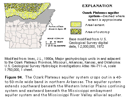
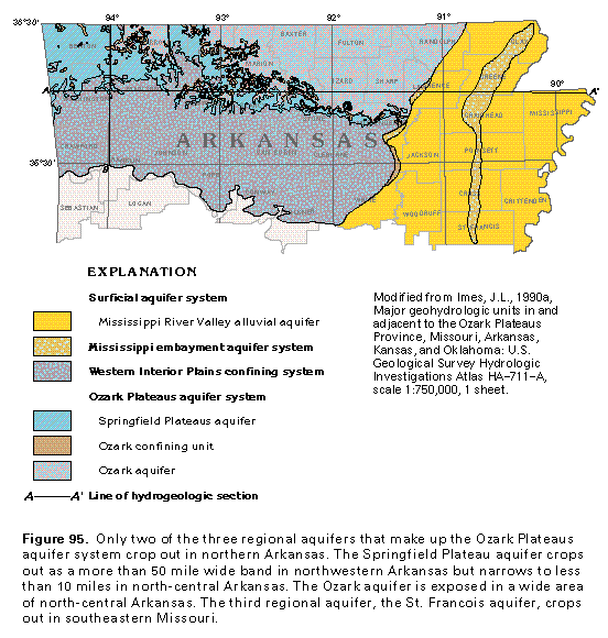
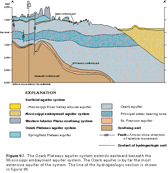
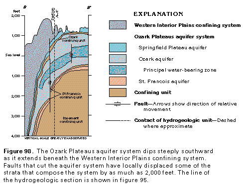
The Ozark Plateaus aquifer system, which includes the Springfield Plateau, Ozark, and St. Francois aquifers, crops out in a 40- to more than 50-mile wide band that extends across most of northern Arkansas (figs. 94, 95). The aquifer system consists of a thick sequence of lithified, flat-lying to southward-dipping limestone and dolomite that contains some beds of sandstone, shale, and chert. Rocks that comprise the system range in age from Cambrian to Mississippian (fig. 96). The aquifer system extends northward into Missouri and westward into southeastern Kansas. It is discussed in detail in Chapter D of this Atlas, which describes aquifers in these States. A small part of the aquifer system extends into eastern Oklahoma and is discussed in Chapter E. The Ozark Plateaus aquifer system extends eastward beneath Coastal Plain and alluvial sediments where it is overlain regionally by the Mississippi embayment aquifer system and locally by the Mississippi River Valley alluvial aquifer (fig. 97). The Ozark Plateaus aquifer system is confined on its southern margin in Arkansas by the Western Interior Plains confining system (fig. 98). Northern Arkansas is physiographically characterized by three erosional plateaus from southwest to northeast-these are the Boston Mountains and the Springfield and the Salem Plateaus. The Western Interior Plains confining system, which is a thick sequence of poorly permeable Pennsylvanian and Mississippian rocks, underlies the rugged topography of the Boston Mountains. The Ozark Plateaus aquifer system underlies the Springfield and the Salem Plateaus.
HYDROGEOLOGIC UNITS
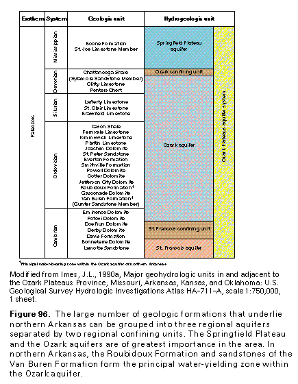
Three regional aquifers, separated by two regional confining units, compose the Ozark Plateaus aquifer system. From shallowest to deepest, the regional aquifers are the Springfield Plateau, the Ozark, and the St. Francois aquifers. The Ozark confining unit separates the Springfield Plateaus and the Ozark aquifers, and the St. Francois confining unit is between the Ozark and the St. Francois aquifers (fig. 96). In Segment 5, the Springfield Plateau aquifer and the upper and the middle parts of the Ozark aquifer yield most of the ground water withdrawn (fig. 97, 98). It usually is not economically feasible to drill wells into the lower parts of the aquifer system that lies at great depths. Only a few wells penetrate the lower parts of the Ozark aquifer, and none are known to produce water from the St. Francois aquifer.
The Springfield Plateau aquifer consists of interbedded Mississippian limestone and chert that generally yield only small volumes of water to wells. Because the aquifer is thin, relative to the great thickness of the Ozark aquifer, and has been highly dissected by erosion, it is used primarily as a source of water for domestic and stock-watering wells. The Springfield Plateau aquifer is underlain by the Ozark confining unit, which consists of the Chattanooga Shale in Segment 5. Where this confining unit is present and has not been breached by erosion, it effectively separates the Springfield Plateau and the Ozark aquifers.
The thick, extensive, and productive Ozark aquifer is the principal source of ground water in northern Arkansas. Although this aquifer consists of numerous geologic formations, which consist chiefly of limestone and dolomite (fig. 96), the most important water-yielding strata in the aquifer are sandstones of the Roubidoux Formation and the Van Buren Formation. Wells that obtain water from these formations commonly yield from 100 to 300 gallons per minute; yields of 500 gallons per minute have been reported for some wells. Shale and dolomite of the St. Francois confining unit underlie the Ozark aquifer and separate it everywhere from the deeper St. Francois aquifer. No wells are known to yield water from the St. Francois aquifer in Segment 5.
SPRINGFIELD PLATEAU AQUIFER
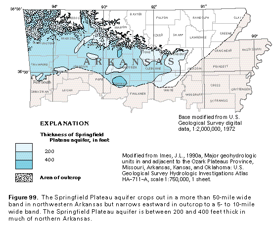
The Springfield Plateau aquifer is the uppermost aquifer of the Ozark Plateau aquifer system. The aquifer crops out along the southern and western perimeter of the Springfield Plateau as a narrow belt 5- to 10-mile wide belt in north-central Arkansas but is exposed in a more than 50-mile wide band in northwestern Arkansas (fig. 99). Outside Segment 5, the Springfield Plateau aquifer extends northward into western Missouri and westward into Oklahoma. Before deposition of the Coastal Plain sediments, erosion removed rocks in northeastern Arkansas equivalent to those that compose the Springfield aquifer. In northern Arkansas, beds of the Springfield Plateau aquifer dip southward beneath the Western Interior Plains confining system and extend to depths of more than 4,000 feet below sea level (fig. 98). The Springfield Plateau aquifer generally ranges from 200 to 400 feet thick throughout northern Arkansas. In Arkansas, the aquifer is composed entirely of the Boone Formation of Mississippian age and is characterized by gray crinoidal limestone and interbedded chert. Its basal member, the St. Joe Limestone, lacks the chert nodules common to the upper part of the formation and is less than 60 feet thick.
Sparse hydrologic data are available for the Springfield Plateau aquifer in northern Arkansas, in part, because the aquifer is exposed in a limited area and, in part, because the aquifer dips steeply beneath the thick shale, siltstone, and sandstone sequence of the Western Interior Plains confining system. Where the aquifer dips beneath this confining system, it is buried at great depths, which makes water-well drilling costs prohibitive. The yield of wells completed in the Springfield Plateau aquifer are reported to range from less than 1 to more than 75 gallons per minute; average yield is reported to be 5 gallons per minute.
OZARK AQUIFER
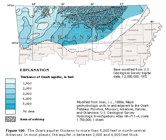
The Ozark aquifer (fig. 100), which is the thickest and most extensive aquifer within the Ozark Plateaus aquifer system of northern Arkansas, comprises limestone and dolomite and includes sandstone and minor chert and shale beds that range from Late Cambrian to Middle Devonian in age. The Ozark aquifer crops out in the deeply dissected, rugged terrain of the Salem Plateau. The aquifer serves as a source of water chiefly for agricultural and domestic purposes but supplies some water for municipal and industrial uses. Outcropping rocks of the Ozark aquifer are nearly flat lying in northern Arkansas, but the dip of the rocks progressively steepens as they extend southward beneath the Ozark confining unit, the Springfield Plateau aquifer, and the north-facing escarpment of the Boston Mountains, which marks the northern extent of the Western Interior Plains confining unit (fig. 98). In northeastern Arkansas, the Ozark aquifer extends eastward beneath the embayed part of the Coastal Plain where the aquifer is overlain by the Mississippi embayment aquifer system and the Mississippi River Valley alluvial aquifer. The Ozark aquifer is more than 5,000 feet thick in the central part of northern Arkansas (fig. 100). The aquifer generally is more than 3,000 feet thick in most outcropping localities. In western Arkansas, the aquifer is less than 1,500 feet thick in local areas in the subsurface.
Although the Ozark aquifer is very thick, most of the water withdrawn from the aquifer is obtained from only a few water-yielding zones. Water-yielding sandstones, such as the Roubidoux Formation and the Gunter Sandstone Member of the Van Buren Formation are notable because of their large yields. The Gasconade Dolomite, which is a bed of cherty dolomite that is about 100 feet thick and yields little water, separates the productive sandstone beds. The Roubidoux Formation is comprised of dolomite, quartz sandstone, and chert and thickens eastward across northern Arkansas from 180 to 260 feet. The yield of wells completed in the formation is reported to average 60 gallons per minute, but some wells yield 600 gallons per minute. The Gunter Sandstone Member is the principal water-yielding zone within the Ozark aquifer; wells that penetrate the unit commonly yield from 150 to 300 gallons per minute, and some wells yield as much as 730 gallons per minute. The Gunter Sandstone Member consists of quartz sandstone; weak to strong cementation of sandstone generally reflects dolomitic or siliceous intergranular cement, respectively. The Potosi Dolomite of Cambrian age is the principal source of water for municipalities in the Salem Plateau area of Missouri, as described in Chapter D of this Atlas. In northern Arkansas, however, the water-yielding characteristics of this formation are poorly understood because it is buried at great depths and, accordingly, is economically unsuited for development as a water resource. Minor water-yielding zones of the Ozark aquifer are contained within the Jefferson City, the Cotter, and the Powell Dolomites; the upper part of the Everton Formation; the St. Peter Sandstone; and the St. Clair, the Lafferty, and the Clifty Limestones (fig. 96). These strata generally yield less than 50 gallons per minute but are capable of yielding as much as 80 gallons per minute. However, the yield of wells completed in these rocks shows that they are not as permeable as the sandstone beds in the lower part of the aquifer.
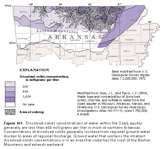
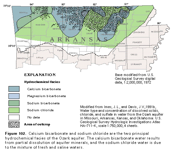
Dissolved-solids concentrations of water in the Ozark aquifer are, for the most part, less than 400 milligrams per liter throughout northern Arkansas (fig. 101). The largest concentrations of dissolved solids are in eastern Arkansas where the aquifer dips beneath the Coastal Plain. The hydrochemical facies reflect, in part, the limestone and dolomite lithology of the aquifer and, in part, saline water in the deeper parts of the aquifer. Most of the water in the Ozark aquifer in northern Arkansas can be classified as either a calcium bicarbonate or a sodium chloride facies (fig. 102). The calcium bicarbonate facies results from the partial dissolution of carbonate rocks that compose the aquifer, whereas the sodium chloride facies is indicative of mixing of freshwater with saltwater contained within the deep, stagnant part of the ground-water flow system. Sodium bicarbonate is representative of a transition zone that separates the fresh and saline parts of the flow system. The small area of magnesium bicarbonate facies is probably due to partial dissolution of dolomite, which is a calcium-magnesium bicarbonate mineral.
ST. FRANCOIS AQUIFER
The St. Francois aquifer, which is the basal aquifer of the Ozark Plateaus aquifer system, is deeply buried in northern Arkansas, usually to depths that range from 1,500 to more than 4,000 feet below land surface (figs. 97, 98). The thickness of the St. Francois aquifer generally is less than 250 feet , and its irregular thickness reflects a rugged Precambrian paleotopographic surface. The aquifer is not used as a source of water in northern Arkansas because the depth to the top of the aquifer makes the costs of drilling and completing wells in the aquifer prohibitively expensive. Other ground-water supplies, which are sufficient in terms of quantity and suitable water quality, are more easily obtained from shallower aquifers.
GROUND-WATER FLOW
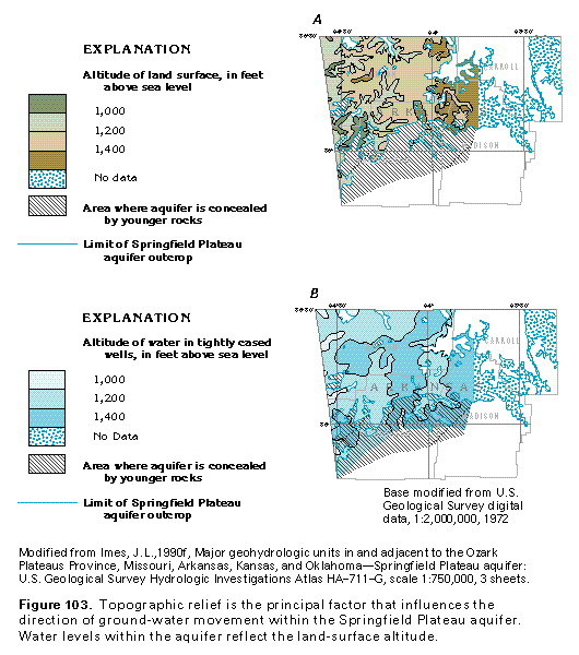
The source of the water that recharges the Ozark Plateaus aquifer system is precipitation that falls on the aquifer system where it is exposed at the land surface. The carbonate rocks that compose the upper parts of the aquifer system are readily dissolved, and the end results of partial dissolution are a network of subsurface openings and an irregular rock surface characterized by sinkholes, caves, and other types of openings, which are called karst topography. Water that recharges an aquifer with a karstified surface either enters as direct runoff through sinkholes and sinking streams (streams that flow into shallow holes and sinkholes) or enters by downward diffuse infiltration through shallow soil cover in the upland, interstream areas. Ground-water flow in the Ozark Plateaus aquifer system tends to be concentrated by a system of well-connected conduits formed by solution-enlarged fractures and bedding-plane partings. Some of the conduits are cavern-sized, form parts of large cave systems and, in places, are part of a subsurface trunk drainage system. Where fractures, bedding-plane partings, and other solution conduits are widely spaced, the flow system tends to be poorly interconnected; in such places, subsurface conduits can cross one another without interference, and water levels can vary widely among closely spaced wells. Conversely, where solution conduits are closely spaced and well-connected, the potentiometric surface will probably reflect the shape of the local topography. Such is the case with the Springfield Plateau aquifer in northwestern Arkansas (fig. 103).
Sparse data are available for the Springfield Plateau aquifer in northwestern Arkansas owing to the limited area in which the aquifer crops out and thick deposits of low-permeability material that overlie the aquifer where it extends beneath the Boston Mountains and the Western Interior confining system. However, regional ground-water flow within the Springfield Plateau aquifer probably is similar to that of the more extensive Ozark aquifer.
The source of most water that enters the Ozark aquifer is precipitation that falls on aquifer outcrop areas. Some water recharges the aquifer by downward leakage from overlying aquifers. For example, the Ozark confining unit (the Chattanooga Shale) is thin (locally absent) and fractured where it overlies the Ozark aquifer and separates it from the Springfield Plateau aquifer in northwestern Arkansas. In this area, water leaks downward from the Springfield Plateau aquifer and recharges the Ozark aquifer.
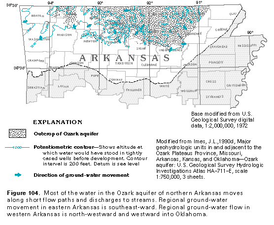
Potentiometric data for the Ozark aquifer suggest that ground-water movement is controlled by topographic relief; much of the water that enters the aquifer is quickly discharged to local streams as indicated by the irregular shape of the aquifers potentiometric surface (fig. 104). Some water, however, moves toward major rivers that serve as points of regional discharge. In extreme northwestern Arkansas, there is a component of westward and northwestward ground-water movement into Oklahoma. Limited data make it difficult to assess the direction of ground-water flow where the Ozark aquifer dips beneath the Western Interior Plains confining system. However, a ground-water divide is thought to underlie the Boston Mountains, and available geologic and hydrologic data suggest that the freshwater part of the flow system probably does not extend very far southward beyond the northern edge of the Western Interior Plains confining system. In the eastern part of the Ozark aquifer, ground-water flow is southeastward. Ground water discharges to the overlying Coastal Plain deposits of the Mississippi embayment aquifer system and the Mississippi River Valley alluvial aquifer.
SOLUTION FEATURES
Dissolution of limestone and dolomite rocks of the Ozark Plateaus aquifer system has resulted in the development of karst terrain in much of northern Arkansas. In the Ozark Plateaus aquifer system, karstic features that have developed on rocks of hydrologic significance include buried cutter and pinnacle bedrock topography, sinkholes, conduit springs, and caves. Solution features are hydrologically important because they serve as the principal conduits for concentrated ground-water flow and, thus, account for practically all the permeability within the Ozark Plateaus aquifer system.
Cutter and pinnacle bedrock topography is not readily visible because it usually is buried beneath a cover of soil and regolith. Cutters are vertical linear solution trenches that generally develop along buried joints or fracture zones. Cutters act as collectors of water that infiltrates through the overlying soil cover and regolith, and they channel the water along the trench before it enters the bedrock through other types of solution openings. Pinnacles, which comprise limestone bedrock, are located between the cutter solution trenches.
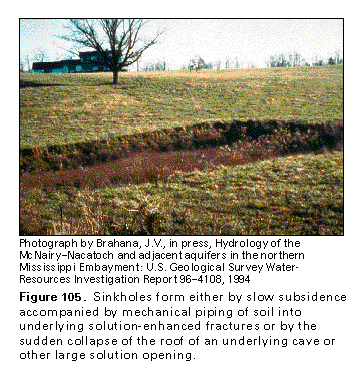
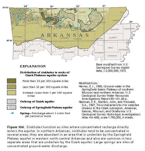
Sinkholes are circular or oval, bowl-shaped depressions that form by the dissolution of underlying carbonate bedrock (fig. 105). Sinkholes range in size from small, local depressions to broad, shallow depressions that extend over an area of a square mile or more. Sinkholes can form by slow subsidence or by sudden collapse. Sinkholes that form by slow subsidence are the result of the dissolution of the upper part of the limestone bedrock and may be accompanied by piping (mechanical transportation) of thick overlying soil into underlying fractures and conduits. Collapse sinkholes form by the sudden collapse of the roof of an underlying cave or other large solution opening. In northern Arkansas, sinkholes are most abundant in the north-central part of the Springfield Plateau, where they develop in the rocks that form the Springfield Plateau aquifer (fig. 106). Sinkholes are less common in the north-central and northeastern areas of northern Arkansas that are underlain by carbonate rock of the Ozark aquifer. Sinkholes are hydrologically important because they are sites where concentrated recharge directly enters the aquifer.
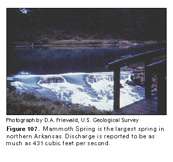
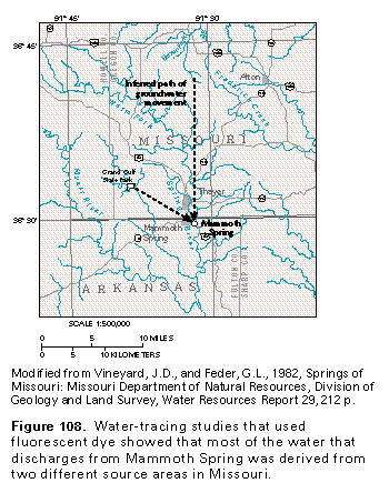
Springs are sites where concentrated discharge emerges from an aquifer at the land surface. In carbonate rocks, the spring flow is channeled along solution conduits to the spring orifice. Many springs that discharge from the Ozark Plateaus aquifer system are located along the sides of deeply incised valleys in the Salem Plateau area and maintain a relatively constant rate of discharge, which is characteristic of springs in the Ozark region. Mammoth Spring (fig. 107), which is the largest spring in Arkansas and the second largest spring that discharges from the Ozark Plateaus aquifer system, is classified as a first-magnitude spring, or a spring whose discharge is 100 cubic feet per second or more. Measured discharge from Mammoth Spring has ranged from 240 to 431 cubic feet per second. Average discharge from other springs in the Segment 5 area is reported to range from less than 1 to about 80 cubic feet per second, which suggests that the other springs probably drain smaller catchment areas. Dye-trace studies of Mammoth Spring have shown that water from this spring discharges from a subterranean system of conduits and channels that extends from 9 to 15 miles to the northwest and north into Missouri (fig. 108).
Caves represent the third major type of solution feature in the Ozark Plateaus aquifer system. An accurate survey of caves is not available for Arkansas; however, more than 1,000 caves with passageways that are 100 feet long are estimated to be in northern Arkansas. Some zones of cavernous porosity have been reported to be more than 1,000 feet below land surface. Caves in northern Arkansas are located mostly within the Springfield and Salem Plateaus, with only a few along the escarpment of the Boston Mountains. The greatest concentration of caves is in the Boone Formation and its lower member, the St. Joe Limestone Member, which are geologic units that compose the Springfield Plateau aquifer. Caves within the Ozark aquifer reportedly are developed in the Kimmswick and Plattin Limestones, the Joachim Dolomite, the Everton Formation, and the Powell Dolomite.
Caves in the Springfield Plateau aquifer formed randomly in response to changes in lithology, fracture density, and the presence or absence of local, low-permeability rock layers that created perched water-table conditions. In the Springfield Plateau aquifer, caves appear to have formed above and below the saturated part of the aquifer. Small caves that formed above the water table were probably caused by discontinuous, poorly permeable shale, siltstone, or chert within the aquifer. These poorly permeable confining units perch water above the main water table, which allows partial dissolution of the limestone or may reflect an earlier, higher base level. The larger, connected caves are within the lower part of the Springfield Plateau aquifer (the St. Joe Limestone Member) where it immediately overlies the Ozark confining unit (the Chattanooga Shale). These caves formed at or below the main water table of the aquifer. Small caves are within some sandstone beds of the Ozark aquifer. These "pseudocaves" probably formed as water leaked downward into solution-enlarged fractures in underlying carbonate strata. Continued dissolution of the underlying carbonate rocks and removal of carbonate cement in the sandstone beds allowed sand to enter solution cavities in the carbonate rocks by piping and (or) cave collapse.
GEOLOGIC FACTORS THAT CONTROL PERMEABILITY
The movement of ground water in the carbonate rocks of the Ozark Plateaus aquifer system is very different from that in the clastic deposits of the surficial aquifer system and the aquifer systems in Coastal Pain clastic sediments. Ground-water moves through clastic materials by diffuse flow through intergranular pore spaces in the poorly consolidated to unconsolidated sediments. The carbonate rocks of northern Arkansas have been subjected to the geologic processes of lithification, compaction, burial, tectonic uplift, and diagenesis during which some to most of the intergranular pore spaces in the rocks have been filled or destroyed. These rocks are very dense and commonly consist of thick-bedded, massive, crystalline limestone and dolomite. Porosity and permeability within such carbonate rocks is, for the most part, secondary. Dissolution of carbonate rocks enlarges vertical fractures caused by joining and faulting and horizontal surfaces formed along bedding planes and unconformities. In some geologic formations, however, movement of water in the carbonate rocks is not limited to these types of secondary openings. For example, ground water within the Potosi Dolomite reportedly moves within interconnected vugs. Vugs are cavities within a carbonate rock that are large enough to be seen without the aid of magnification and do not necessarily conform to the internal fabric of the rock.
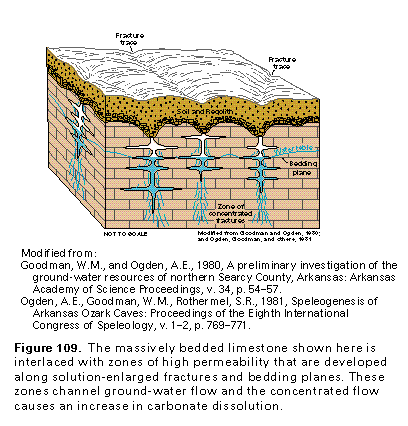
As described above, the dense crystalline limestone and dolomite strata of northern Arkansas transmit water chiefly through fractures and along bedding planes that have been enlarged by dissolution. As precipitation falls through the atmosphere, it absorbs small amounts of carbon dioxide to form a weak carbonic acid. Much more carbon dioxide is absorbed from plant roots and decaying organic matter in the soil as the precipitation infiltrates through the soil cover and percolates downward to underlying limestone and dolomite bedrock. Water that enters fractures dissolves parts of the adjoining bedrock, which slowly enlarges the fractures. As the fractures widen to form conduits, more water is funneled to the conduits that grow even larger. Soil and regolith thicken over these fracture zones; contain more decaying organics, and thus higher concentrations of carbon dioxide; and serve as an even greater source of carbonic acid. The high permeability zones within dense crystalline rocks of the Ozark Plateaus aquifer system are characteristically separated by low-permeability, unfractur-ed blocks of limestone and dolomite through which water moves more slowly (fig. 109).
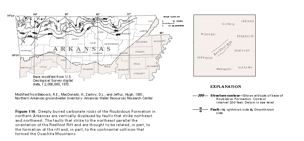
The development of a vertical fracture system that has created directional differences in permeability within the Ozark Plateaus aquifer system is thought to be related, at least in part, to the continental collision that helped form the Ouachita Mountains and, in part, to tectonic stresses associated with the formation of the Reelfoot Rift. The Reelfoot Rift is a northeast-trending graben structure that is buried beneath the Coastal Plain sediments in northeastern Arkansas and has been intermittently active from late Precambrian to Holocene time. Northeast- and northwest-trending faults, grabens, and half-graben structures also vertically displace deeply buried rocks of the Roubidoux Formation, which is part of the Ozark Plateaus aquifer system (fig. 110).
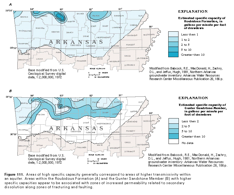
The specific capacity of a well is the rate the well yields water per unit of distance the water level in the well drops as the well is being pumped. Specific capacity is usually expressed as gallons per minute (the rate) per foot of drawdown (the water level drop). In general, high values of specific capacity indicate that wells are completed in an aquifer that has a high transmissivity, and low specific capacities suggest the aquifer has a low transmissivity. Regional fault and (or) fracture zones appear to be directly related to variations in the specific capacity of wells with two water-yielding zones of the Ozark aquifer. These zones are the Roubidoux Formation and the Gunter Sandstone Member of the Van Buren Formation. Areas of high specific capacity in both geologic units seem to correlate with areas that are in proximity to inferred faults and horst and graben structures (compare fig. 110 and fig. 111). The areas of high specific capacity within the Roubidoux Formation appear to be related to the development of increased secondary permeability due to dissolution along fault and fracture zones.
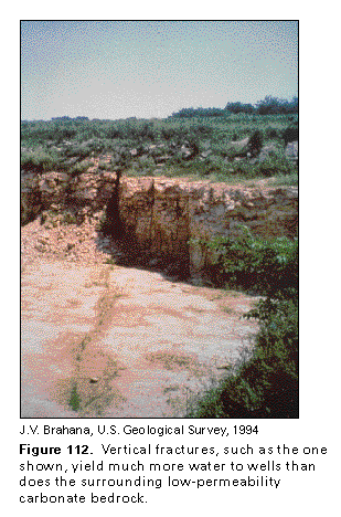
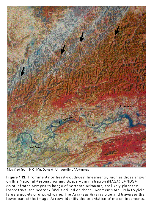
A well completed in a carbonate-rock aquifer is likely to yield large volumes of water if the well is drilled into a fracture zone (fig. 112). Vertical fracture zones commonly are expressed as linear topographic features at the land surface. These linear features, which are called lineaments, may consist of straight stream segments, aligned sinkholes, or different soil colors, all of which can be seen on aerial photographs (fig. 113). Some of the linear features extend continuously or discontinuously for many miles. Individual fracture traces are aligned parallel to the lineaments but are smaller in lateral extent. Numerous studies have shown a strong correlation between aquifer transmissivity and photographic lineaments in the Ozark Plateaus aquifer system of northern Arkansas. Hydrologic studies in northern Arkansas also indicate that areas of fractured rock commonly have a greater thickness of regolith than those of nonfractured rocks; the same investigations show that well yields are greater in areas with a thicker regolith. The thick regolith serves to store ground water and subsequently releases the stored water slowly so that it percolates downward into bedrock aquifers. The largest limestone and dolomite conduits may parallel the orientation of regional fracture systems rather than local fracture bedrock systems.