INTRODUCTION
The surficial aquifer system (fig. 15) in the southeastern United States includes any otherwise undefined aquifers that are present at the land surface. Even though the sand and gravel aquifer of Florida and southwestern Alabama, and the Biscayne aquifer of southern Florida are present at the land surface and are the lateral equivalents of the surficial aquifer system, they are treated separately in this Atlas because of their importance as water sources. The sand and gravel, and the Biscayne aquifers supply large municipalities; the surficial aquifer system, although used by a large number of people, principally is used only for domestic, commercial, or small municipal supplies.
The thickness of the surficial aquifer system is typically less than 50 feet, but its thickness in Florida is as much as 400 feet in Indian River and St. Lucie Counties; 250 feet in Martin and Palm Beach Counties; and 150 feet in eastern St. Johns County. In southeastern Georgia, thicknesses of about 60 feet have been mapped for the system. The system generally thickens coastward.
HYDROGEOLOGIC UNITS
The surficial aquifer system consists mostly of beds of unconsolidated sand, shelly sand, and shell. Locally, in southwestern Florida, limestone beds form an important and highly permeable part of the system. In places, clay beds are sufficiently thick and continuous to divide the system into two or three aquifers; mostly, however, the system is undivided. Complex interbedding of fine- and coarse-textured rocks is typical of the system.
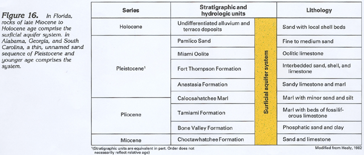
The rocks that comprise the surficial aquifer system range from late Miocene to Holocene in age. Although figure 16 shows that nine geologic formations are part of the system at different places in Florida, the entire sequence of formations is not present at any one location. The formations are thin and mostly lens-like, and it is unusual for more than three or four of them to comprise the aquifer system at any place. Many of the geologic formations shown interfinger with each other, and some of them, such as the Caloosahatchee Marl, are not particularly productive aquifers. In Georgia and South Carolina, unnamed, sandy, marine terrace deposits of Pleistocene age and sand of Holocene age comprise the system. These sandy beds commonly contain clay and silt. In Alabama, a thin, unnamed sand of Holocene age comprises the system.
Limestone beds of the Tamiami and Fort Thompson Formations, mostly restricted to southern and southwestern Florida, are the most productive parts of the surficial aquifer system. Yields from these formations are especially large where large-scale openings have been developed by dissolution of part of the limestone. In places where the combined Pamlico Sand and overlying sand deposits of Holocene age are 40 feet or more thick, moderate yields are obtained; elsewhere, the system generally does not yield much water.
GROUND-WATER FLOW
Ground water in the surficial aquifer system is under unconfined, or water-table, conditions practically everywhere. Locally, thin clay beds create confined or semiconfined conditions within the system. Most of the water that enters the system moves quickly along short flowpaths and discharges as baseflow to streams.
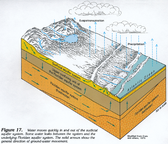
The general movement of water within the system is illustrated in figure 17, which is an idealized diagram representing hydrologic conditions in Indian River County, Fla. Water enters the system as precipitation. A large percentage of this water is returned to the atmosphere by evapotranspiration. Water that is not returned to the atmosphere by evapotranspiration, or that does not directly run off into surface-water bodies, percolates downward into the surficial aquifer system and then moves laterally through the system until it discharges to a surface-water body or to the ocean.
In places, some water leaks upward from the underlying Floridan aquifer system through the clayey confining unit separating the Floridan and surficial systems (fig. 17). In other places, where the hydraulic head of the Floridan is lower than the water table of the surficial aquifer, leakage can occur in the opposite direction.
Because the surficial aquifer system extends seaward under the Atlantic Ocean, saltwater can encroach into the aquifer in coastal areas. Encroachment is more extensive during droughts because there is less freshwater available in the surficial aquifer system to keep the saltwater from moving inland.
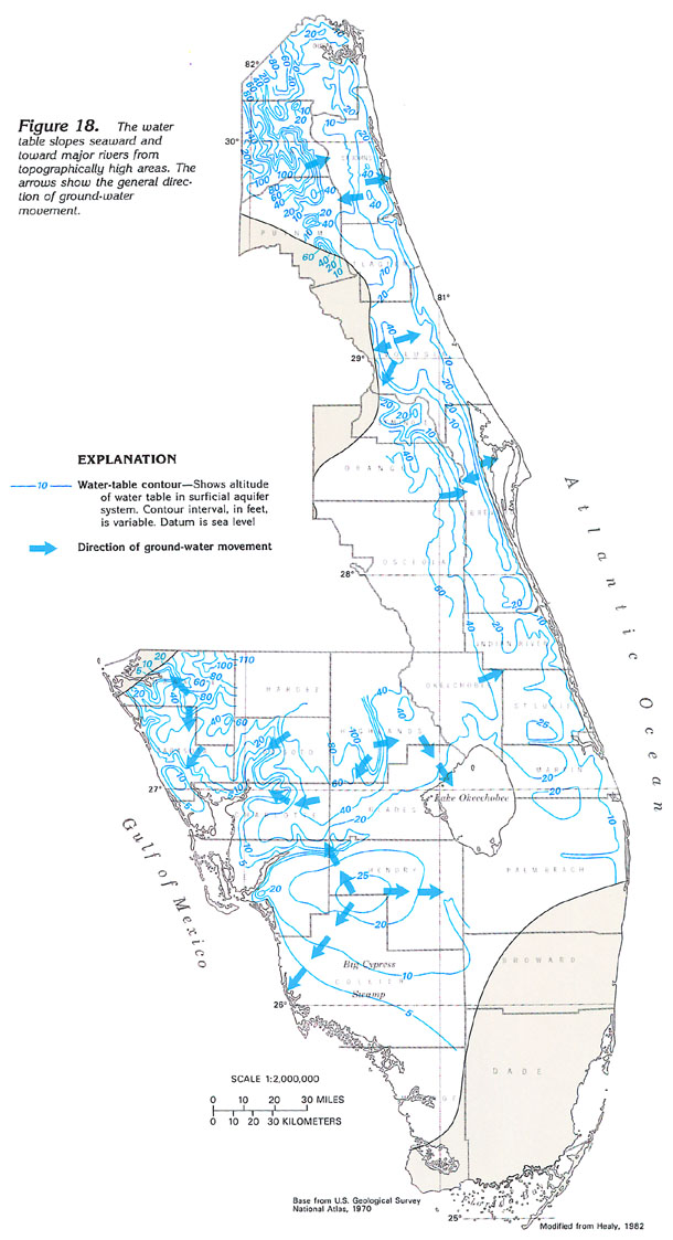
The configuration of the long-term, average water table of the surficial aquifer system, where it has been mapped in the eastern and southern part of the Florida peninsula, is shown in figure 18. The water-table configuration is generally a subdued reflection of the topography of land surface. Steep gradients occur between streams and ridges or hills, and gentle gradients occur in broad, flat interstream areas and under broad topographic highs.
The arrows in figure 18 show that the general direction of ground-water movement is toward the Atlantic Ocean, the Gulf of Mexico, or toward major rivers. The water-table surface is complex, reflecting the fact that water in the surficial aquifer system moves quickly toward the nearest surface-water body. Accordingly, local directions of ground-water movement change markedly within short distances.
The wide spacing of the contours in Collier County and adjacent areas reflects two conditions: (1) the Big Cypress Swamp, which is virtually flat, is present throughout much of this area; and (2) the surficial aquifer system largely consists of highly permeable limestone in this area. Steeper gradients elsewhere are more typical of a sand aquifer in an area of gentle topography.
The transmissivity of the surficial aquifer system is extremely variable. Most reported values range from 1,000 to 10,000 feet squared per day; in places, values of 25,000 to 50,000 feet squared per day have been reported. The larger values are primarily for beds of shell or limestone. Well yields range from less than 50 gallons per minute in most of Georgia and South Carolina, to 450 gallons per minute in St. Johns County, Fla., to 1,000 gallons per minute in Indian River County, Fla.
FRESH GROUND-WATER WITHDRAWALS
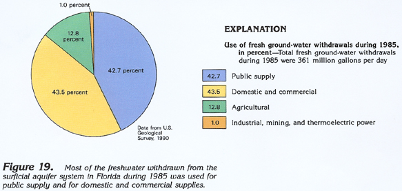
Water-use data are available for the surficial aquifer system only from Florida. About 361 million gallons per day of freshwater was withdrawn from the surficial aquifer system in Florida during 1985. Nearly equal volumes were withdrawn for public supply and for domestic and commercial uses (fig. 19), with withdrawals for these categories being about 154 and 157 million gallons per day, respectively. Agricultural withdrawals accounted for about 13 million gallons per day, and withdrawals for industrial, mining, and thermoelectric-power uses were about 4 million gallons per day, primarily for industrial use.