
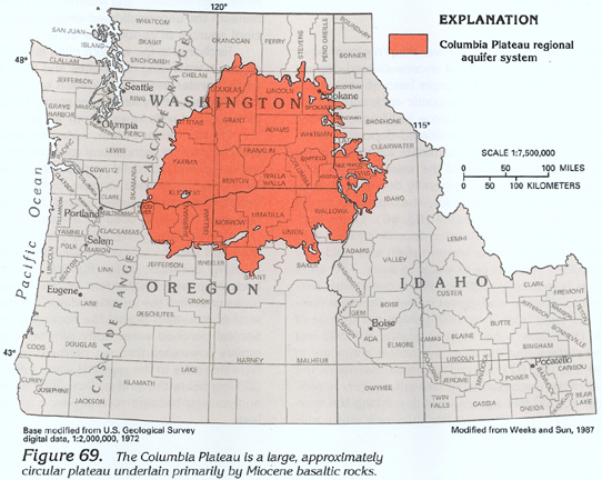
The Columbia Plateau regional aquifer system occupies about 50,600 square miles and extends across a small part of northern Idaho, northeastern Oregon, and a large part of southeastern Washington (fig. 69). During 1984, about 3,500 wells were pumped to irrigate about 500,000 acres on the Columbia Plateau.
The Cascade Range in Oregon and Washington is an important recharge area for the Columbia Plateau regional aquifer system. Ground water is little used in the Cascade Range, volcanic rocks of the volcanic- and sedimentary-rock aquifer are extremely permeable and readily accept large volumes of precipitation that recharge underlying aquifers.
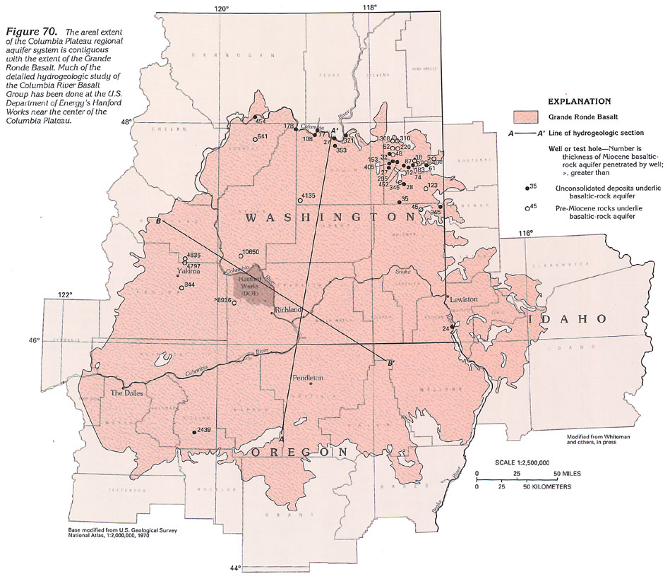
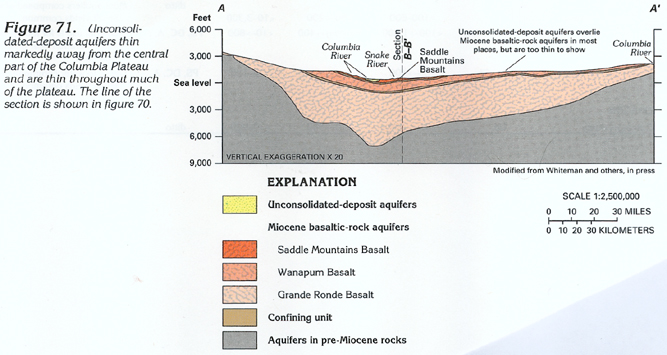
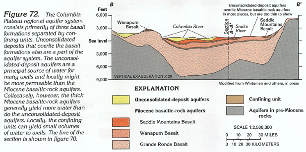
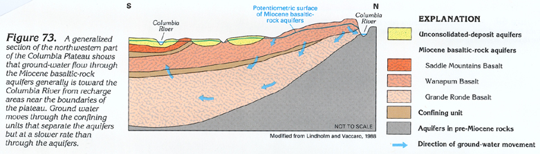
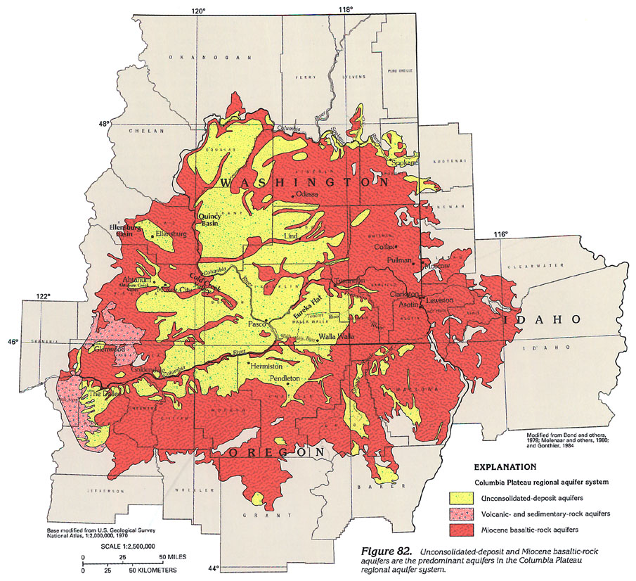
Miocene basaltic rocks are generally the major aquifers. The Grande Ronde Basalt is the most extensive basalt formation that underlies the Columbia Plateau (fig. 70). The extent of the plateau coincides with the limits of the Grande Ronde Basalt. The Grande Ronde Basalt and the overlying Wanapum and Saddle Mountains Basalt, which are called the Columbia River Basalt Group, compose most of the aquifer system (figs. 71 and 72). The Miocene basaltic-rock aquifers are as much as 15,000 feet thick in places and are overlain by unconsolidated-deposit aquifers that also are part of the aquifer system. The Miocene basaltic-rock and the unconsolidated-deposit aquifers are thicker near the center of the plateau. Geologic structures are important controls on ground-water occurrence and movement in the Columbia Plateau. Folded and subsequently eroded layers of rock crop out in upland areas where water enters the aquifer system; the water then moves downgradient along permeable zones. In places, tight folds or faults or both and gently dipping layers of rock sloping opposite to the direction of ground-water movement can impede the movement of ground water. The general movement of water in the aquifer system is from recharge areas near the edges of the plateau toward regional drains, such as the Columbia River (fig. 73).
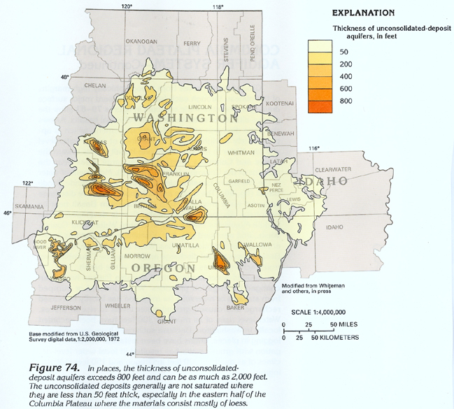
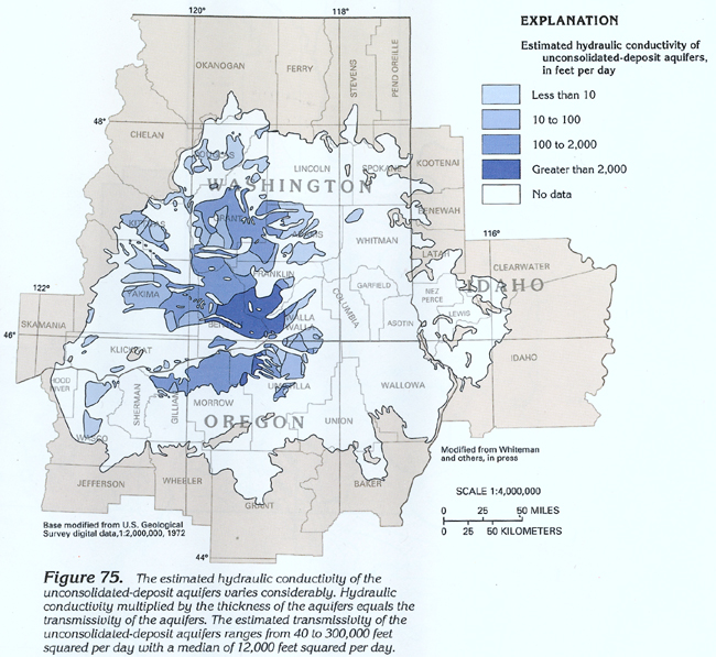
In places, unconsolidated-deposit aquifers are more important aquifers than are the Miocene basaltic-rock aquifers. The thickness of the unconsolidated-deposit aquifers exceeds 200 feet in many areas (fig. 74) and is locally more than 800 feet (as much as 2,000 feet in places). The estimated hydraulic conductivity of these aquifers (fig. 75) is extremely variable but is large enough in places so that the aquifers are productive, especially where they are thick.
Individual basalt flows in the Columbia River Basalt Group range from a few tens of feet to about 300 feet in thickness and average about 100 feet. Some thick flows that are exposed in canyons and road cuts display extensive fracture patterns owing to differential rates of cooling. The tops and the bottoms of flows typically are permeable because of rubble zones, vesicles, and fractures. Some of these open spaces, however, are filled with clay minerals that decrease permeability. The central parts of most flows are dense and almost impermeable. Openings that have been caused by minor vertical cooling fractures might provide some permeability in the central part of the flows.
Wells that are deep enough to penetrate several interflow zones in the Miocene basaltic-rock aquifers can yield large volumes of water; however, wells commonly need to be drilled several hundred feet deeper than the top of the saturated zone to obtain a desired yield. Expected yields of Miocene basaltic-rock aquifers are about 1.5 gallons per minute for each foot of saturated material penetrated. Unconsolidated-deposit aquifers (chiefly glacial outwash) yield as much as 0.5 gallon per minute for each foot of saturated material penetrated.
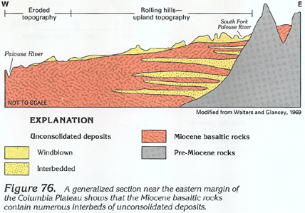
On the basis of rock geochemical differences and sedimentary interbeds, the Columbia River Basalt Group sequence has been divided, from oldest to youngest, into three main units: the Grande Ronde Basalt, the Wanapum Basalt, and the Saddle Mountains Basalt. The Grande Ronde Basalt, which is the thickest, contains as many as 131 flows; the Wanapum Basalt, as many as 33 flows; and the Saddle Mountains Basalt, as many as 14 flows. Interbeds separate the three basalt formations (figs. 71 and 72). Interbedded unconsolidated deposits are more prevalent near the eastern margin of the plateau (fig. 76). In the east-central parts of the plateau, the basalt sequence is relatively free of interbedded unconsolidated deposits, except for the interbed that separates the Wanapum Basalt and the Grande Ronde Basalt. This interbed is present throughout much of the plateau. In most places, the interbeds are confining units. The bedrock that underlies the Columbia River Basalt Group consists of pre-Miocene igneous, metamorphic, and consolidated sedimentary rocks.
The extent of the Grande Ronde Basalt is shown in figure 70. Its thickness is known at only a few places, mostly near the edges of the plateau.
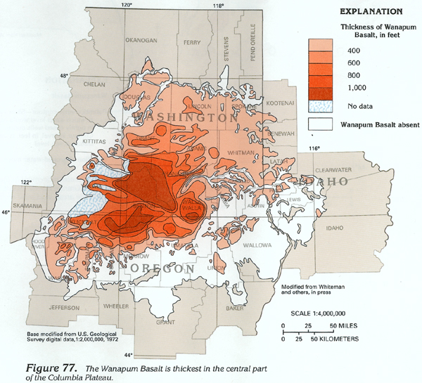
The Wanapum Basalt, which extends over almost as much area as the Grande Ronde Basalt, is much thinner (fig. 77). In a few places, the Wanapum Basalt is more than 1,000 feet thick.
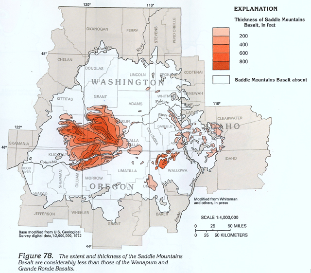
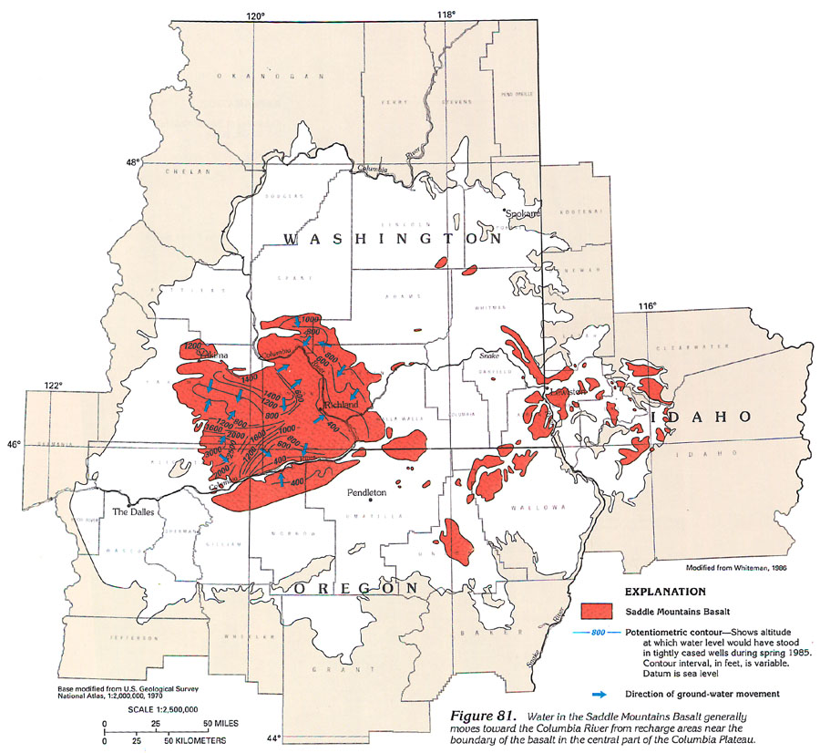
The Saddle Mountains Basalt is much thinner and extends over a much smaller area than either the Wanapum or the Grande Ronde Basalts (fig. 78). In a few small areas, the Saddle Mountains Basalt is more than 800 feet thick.
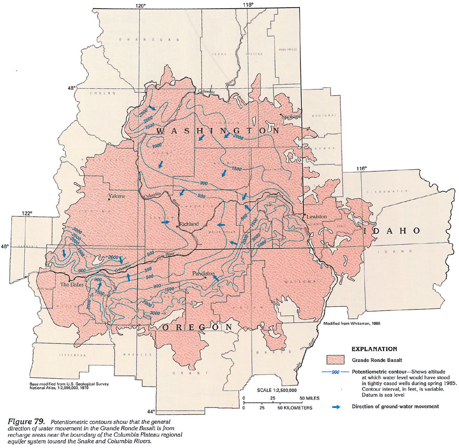
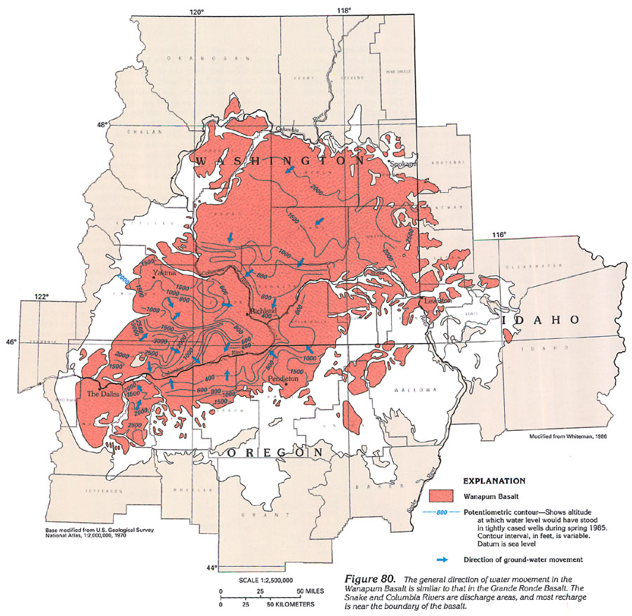
Ground water moves from topographically high margins of the plateau through each basalt unit toward major surface drainages. Potentiometric contours in figures 79-81 show the general altitude of water levels in the individual basalts. Arrows show the direction of ground-water movement, which is approximately at right angles to the lines of equal water-level altitude. Water in the Grande Ronde Basalt moves toward the Snake and Columbia Rivers from recharge areas near the margins of the Columbia Plateau (fig. 79). Movement of water in the Wanapum Basalt is similar to that in the Grande Ronde Basalt (fig. 80). The Snake and Columbia Rivers are discharge areas for water that recharges the Wanapum Basalt near its periphery. Regional ground-water flow is developed in the Saddle Mountains Basalt only in central Walla Walla County, Wash., and westward (fig. 81). Elsewhere, flows of this basalt are local, discontinuous bodies. Water in the Saddle Mountains Basalt moves toward discharge areas along the Columbia River from recharge areas near boundaries of the basalt.
Ground-water levels in the Columbia Plateau have been changed by irrigation practices. Water diverted or pumped from streams or reservoirs for irrigation has locally increased recharge and caused ground-water levels to rise in places. Water-level rises of as much as 300 feet have been recorded locally in Washington. Because such rises have caused waterlogging in places, drains have been installed. Conversely, irrigation with ground water has resulted in local water-level declines of as much as 300 feet in Oregon and 150 feet in Washington.
A synopsis of some aspects of the ground-water system in the
Columbia Plateau area (fig. 82) is presented below:
· The principal unconsolidated-deposit aquifer in Spokane
County, Wash., is composed of glacial outwash filling a preglacial
valley. The deposits are coarse sand and gravel that are as much
as 880 feet thick. Yields of as much as 5,000 gallons per minute
have been obtained from some wells north of Spokane, Wash.; one
well reportedly yielded 19,000 gallons per minute. Near the junction
of Chemokane Creek and Spokane River, clay is mixed with the sand
and gravel, and well yields range from 100 to 500 gallons per
minute. Southwest of Spokane, the Miocene basaltic rocks constitute
important aquifers.
· In Latah County, Idaho, and Whitman County, Wash., Miocene
basaltic-rock aquifers supply water for Moscow, Idaho, and Pullman,
Wash. Some wells that are as much as 1,400 feet deep yield as
much as 1,500 gallons per minute. Many of the wells flowed initially,
but extensive pumping since the early 1920's has caused the hydraulic
head to decline, and these wells no longer flow. Some wells near
the town of Colfax, Wash., and in other parts of the area, however,
still flow; about 6 miles northeast of Colfax, a 106-foot-deep
municipal well flowed 1,550 gallons per minute when drilled in
1927. Since then, the hydraulic head in this area has declined,
and the flow rate of the well has decreased substantially.
· Near Odessa and Lind in Lincoln and Adams Counties, Wash.,
ground water is used extensively for irrigation. Wells completed
in the Miocene basaltic-rock aquifers yield from 150 to 3,800
gallons per minute, except near basin margins where the basalt
thins and well yields are smaller.
· In the Quincy Basin in Grant County, Wash., unconsolidated
deposits that are as much as 1,000 feet thick yield as much as
3,200 gallons per minute to wells for public-supply, domestic
and commercial, and agricultural (primarily irrigation) purposes.
Miocene basaltic rocks that underlie the unconsolidated deposits
yield as much as 4,800 gallons per minute. Unconsolidated-deposit
aquifers (primarily sand and gravel) along the Columbia River
in the southern part of Grant County yield as much as 1,800 gallons
per minute to wells.
· Near Pasco in Franklin County, Wash., unconsolidated-deposit
aquifers yield as much as 3,900 gallons per minute to wells where
the aquifers are mostly sand. Commonly, however, well yields are
much less where the clay content is greater.
· In the Ellensburg Basin in Kittitas County, Wash., unconsolidated
deposits that are as much as 1,000 feet thick yield as much as
3,200 gallons per minute to wells for public-supply, domestic
and commercial, and agricultural (primarily irrigation) purposes.
Miocene basaltic rocks that underlie the unconsolidated deposits
yield as much as 4,800 gallons per minute.
· In Yakima County, Wash., unconsolidated-deposit aquifers
that are greater than 800 feet thick and that underlie Miocene
basaltic-rock aquifers provide water for public-supply, domestic
and commercial, agricultural (primarily irrigation), and industrial
purposes. In Ahtanum Creek Valley, a 2,760-foot-deep artesian
well flowed 2,000 gallons per minute when drilled years ago. Near
Moxee City, wells that range from 900 to 1,320 feet deep yield
from 200 to 875 gallons per minute.
· Artesian wells are common in parts of Kittitas and Yakima
Counties, Wash. Flows from 600- to 1,300-foot-deep wells that
are completed in Miocene basaltic-rock aquifers range from 300
to about 2,000 gallons per minute. Such flows are not obtained
everywhere because the permeability of the aquifers varies greatly.
· In Klickitat County, near Glenwood, Wash., wells that
are less than 160 feet deep and that are completed in unconsolidated
deposits yield as much as 500 gallons per minute. Near Goldendale,
in the same county, some wells that range from 100 to 1,100 feet
deep and that are completed in Miocene basaltic rocks yield as
much as 1,500 gallons per minute.
· In the southern part of Benton County and the eastern
part of Klickitat County, Wash., unconsolidated deposits and Miocene
basaltic rocks are aquifers; the Miocene basaltic rocks are the
major aquifers. Several irrigation wells that range from 200 to
1,000 feet deep have artesian flows of 2,000 to 4,000 gallons
per minute. Near the Columbia River in Benton County, yields of
50 to 1,000 gallons per minute are obtained from 30- to 50-foot-deep
wells that are completed in unconsolidated deposits. Elsewhere,
yields of 10 to 200 gallons per minute are common from 150- to
1,100-foot-deep wells that are completed in Miocene basaltic rocks.
· In Columbia and Walla Walla Counties, Wash., unconsolidated
deposits as much as 800 feet deep fill basins such as the Walla
Walla River Valley. In the vicinity of the city of Walla Walla,
these deposits (primarily sand and gravel) yield as much as 1,000
gallons per minute to wells. Unconsolidated-deposit aquifers along
the Touchet and the Tucannon Rivers are much less productive,
but yields might be adequate for domestic use and local irrigation
supplies. The unconsolidated deposits are underlain by Miocene
basaltic rocks. Wells that were completed at depths of 100 to
2,000 feet in the Miocene basaltic rocks are used for public-supply,
agricultural (primarily irrigation), and industrial purposes;
yields range from 30 to 3,000 gallons per minute. When drilled
in 1945, some wells flowed; since then, however, flows have decreased
greatly or have ceased. Depth to water beneath Eureka Flat ranges
from 500 to 1,000 feet below land surface, and well yields are
commonly less than 15 gallons per minute.
· Aquifers in the eastern part of the Columbia Plateau
in Idaho generally are discontinuous and isolated. Demand for
ground water usually is limited to domestic and commercial or
small public supplies in lowland areas. Wells in Nez Perce County,
Idaho, yield from 1 to 2,000 gallons per minute of water, although
small yields are more common. The most intensive ground-water
development in Nez Perce County, Idaho, and Asotin County, Wash.,
is near the towns of Lewiston, Idaho, and Asotin and Clarkston,
Wash. Wells withdraw water for public-supply, domestic and commercial,
agricultural, and industrial purposes. Water-resource development
in the remainder of the area is sparse because of rugged topography
and small population.
· Ground-water development is extensive in much of the
area from near The Dalles, Oreg., eastward to Pendleton, Oreg.,
where unconsolidated deposits (primarily sand and gravel) and
Miocene basaltic rocks are aquifers. The sand and gravel is as
much as 600 feet thick. Rapid water-level declines in The Dalles
area prompted the State of Oregon to designate it a Critical Ground-Water
Area during 1959. Intensive pumping of artesian aquifers for irrigation
near Pendleton has resulted in hydraulic head declines of 2 to
5 feet per year since 1966.
· Unconsolidated deposits fill the broad Grande Ronde Valley
in Union County, Oreg., to depths of as much as 2,000 feet. Typically,
the deposits are fine grained near the center of the valley and
coarser near the valley margins. The deposits are underlain by
basalt.
Information pertaining to ground-water conditions in the Columbia
Plateau is summarized by county in table
4.