CENTRAL LOWLAND AQUIFERS
INTRODUCTION
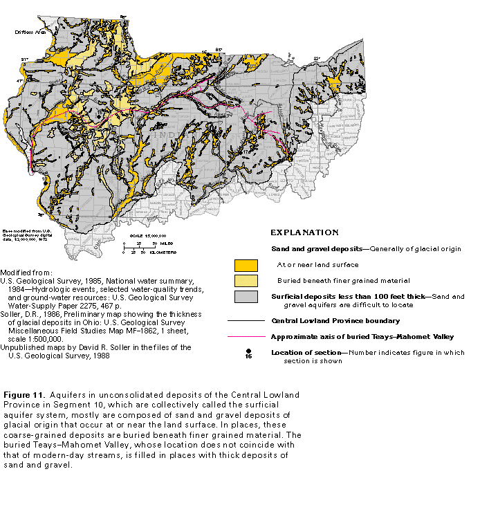
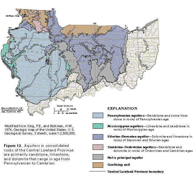
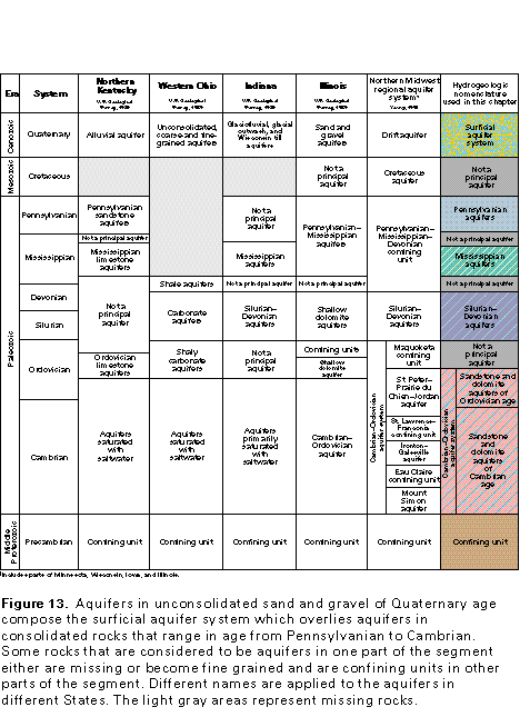
The aquifers of the Central Lowland Physiographic Province consist of unconsolidated sand and gravel deposits of Quaternary age (fig. 11) and consolidated sandstone, limestone, and dolomite of Paleozoic age (fig. 12). The principal aquifers in Paleozoic rocks primarily are sandstone of Pennsylvanian age, limestone and sandstone of Mississippian age, dolomite and limestone of Devonian and Silurian age, and sandstone and dolomite of Ordovician and Cambrian age (fig. 13).
The geologic and hydrogeologic nomenclature used in this chapter differs from State to State because of independent geologic interpretations and varied distribution and lithology of rock units. A fairly consistent set of nomenclature, however, can be derived from the most commonly used rock and aquifer names. Therefore, the nomenclature used in this report is essentially a synthesis of that of the U.S. Geological Survey, the Illinois State Geological Survey, the Illinois State Water Survey, the Indiana Geological Survey, the Kentucky Geological Survey, the Ohio Geological Survey, and the Tennessee Department of Conservation, Division of Geology. Individual sources for nomenclature are listed with each correlation chart in this chapter.
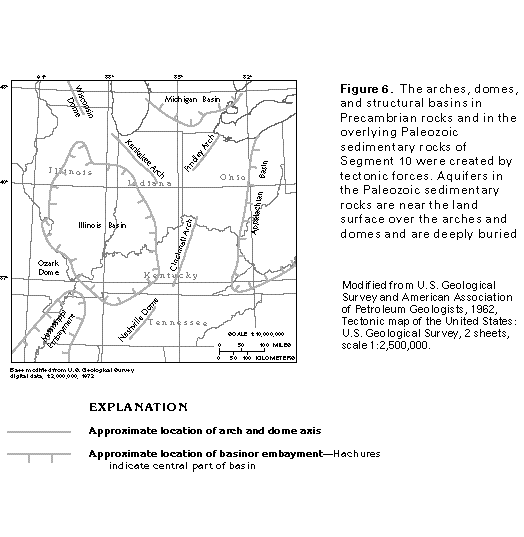
The Central Lowland Province in Segment 10 is characterized by a low-relief surface formed by glacial till, outwash plains, and glacial-lake plains. Long, low, arcuate ridges, which were formed by recessional moraines and generally are concave to the north, are common features on these plains. The glacial deposits that compose the ridges and plains have completely buried the preglacial topographic features of most of the segment. Parts of the buried bedrock valleys, such as the Mahomet Valley section of the buried Teays-Mahomet bedrock valley system in central Illinois (fig. 11), contain unconsolidated deposits of sand and gravel that constitute productive aquifers. The Paleozoic rocks that underlie the glacial deposits dip gently away from the axes of the Cincinnati, the Kan-kakee, and the Findlay Arches and the southern extension of the Wisconsin Arch (fig. 6) into structurally low areas, such as the Illinois, the Michigan, and the Appalachian Basins. On the arches and domes, the older Paleozoic rocks directly underlie the glacial deposits near the axes of the folds; in the structural basins, the younger Paleozoic rocks are directly beneath the glacial materials near the centers of the folds.
The depth to which freshwater circulates in the consolidated rocks depends on a number of factors, including the per-meability of the aquifers in the consolidated rocks, and on the number, thickness, and permeability of confining units that are present in the consolidated rocks and in the overlying unconsolidated deposits. For example, the freshwater flow system is deep in northern Illinois where the aquifers in consolidated rocks of Ordovician and Cambrian age transmit water from aquifer outcrop and shallow subcrop areas in central Wisconsin to depths of about 2,000 feet in the Chicago, Ill., area. A freshwater flow system also exists in the aquifers in dolomite and limestone of Devonian and Silurian age in the eastern part of the segment in Indiana and Ohio. In contrast, the aquifers in limestone and sandstone of Mississippian age are saturated with saltwater in Illinois and Indiana, except in areas where these rocks crop out. The aquifers in Mississippian rocks in Illinois and Indiana mostly are overlain by Pennsylvanian rocks that are interlayered shale, siltstone, sandstone, limestone, and coal. The interlayered shale and siltstone form confining units that impede the downward movement of the freshwater and the flushing of saltwater from the underlying aquifers in Mississippian rocks.
Unconsolidated glacial deposits of Quaternary age overlie the consolidated Paleozoic rocks throughout most of the Central Lowland Province in Segment 10. However, Silurian and Ordovician rocks are at the land surface in the Driftless Area in northwestern Illinois, and rocks of Pennsylvanian through Ordovician age are at the land surface along the boundary be-tween the Central Lowland and the Ozark Plateaus Provinces in southwestern Illinois.
The unconsolidated Quaternary deposits are saturated with freshwater throughout the segment. The water moves through the void spaces between the mineral grains and rock particles that constitute the deposits. The upper part of the consolidated Paleozoic rocks that underlie the Quaternary deposits also is saturated with freshwater, which moves through primary pore spaces in some of the sandstone units and secondary openings, such as fractures and bedding planes, in all the consolidated rocks. In limestone and dolomite, these secondary openings are often enlarged by the dissolution of the carbonate rocks. As a consequence of this enlargement, the limestone and dolomite form the most productive aquifers in consolidated rocks in the segment.
SURFICIAL AQUIFER SYSTEM
Some of the most productive aquifers in the Central Lowland Province in Segment 10 consist of Quaternary sand and gravel deposits (fig. 11). These deposits, which are collectively called the surficial aquifer system, supply more than 50 percent of the fresh ground water withdrawn in the segment. The Quaternary deposits primarily are material of glacial origin. Even the Holocene alluvium present in some river valleys mostly is derived from reworked glacial deposits. The different combinations of clay, silt, sand, and gravel that compose the glacial material were deposited during at least three stages of advance and retreat of the ice. In places where they were directly emplaced by the ice, these deposits, called till, are poorly sorted mixtures of clay, silt, sand, gravel, and boulders and generally are not productive aquifers. In other places, sediments deposited by glacial meltwater consist of coarse sand and gravel that are productive aquifers.
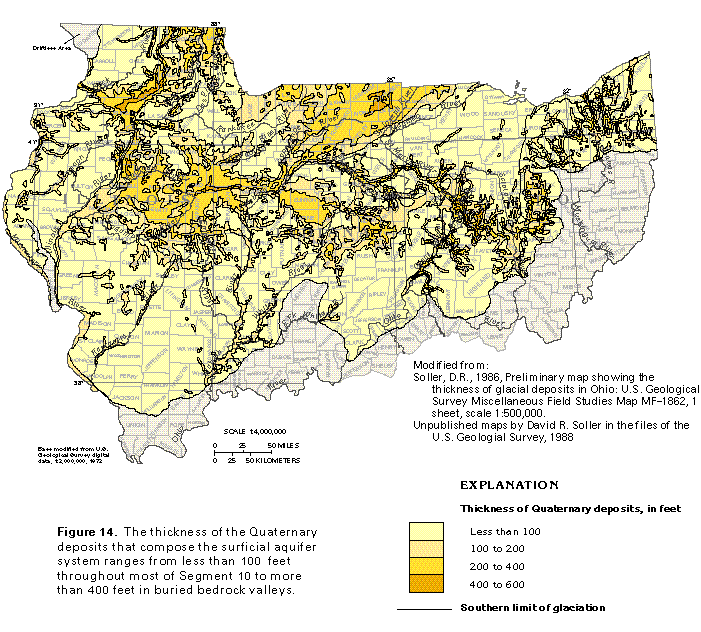
The range in thickness of the Quaternary deposits in the northern part of Segment 10 is shown in figure 14. The thickness of the deposits ranges from less than 100 feet in most of the segment to between 400 and 600 feet in buried bedrock valleys. The thickest deposits are mostly in west-central Ohio, northeastern Indiana, and northern and central Illinois.
Most of the principal sand and gravel deposits that are known to constitute aquifers are shown in figure 11. These coarse-grained deposits have been divided into two categories: deposits that are at or near land surface and those that are buried beneath fine-grained material. Sand and gravel deposits at or near land surface mostly are in the present river valleys and upland areas. Those deposits buried beneath fine-grained material are in former river valleys (valleys cut into bedrock) that have been filled with glacial material, such as the buried Teays-Mahomet Valley that extends through parts of Illinois, Indiana, and Ohio.
Hydrogeologic Setting
The lateral extent, thickness, and hydraulic characteristics of each of the numerous sand and gravel aquifers and clay and silt confining units that make up the surficial aquifer system are difficult to map at a regional scale because the distribution of the sediments is extremely complex. Consequently, examples from different areas within the Central Lowland Province in Segment 10 are used to illustrate the similarities and differences in the hydrology of these deposits.
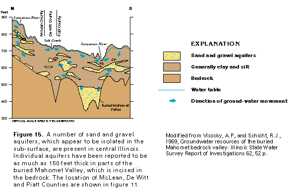
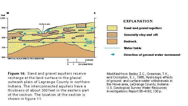
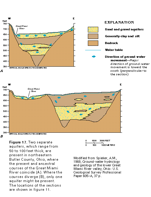
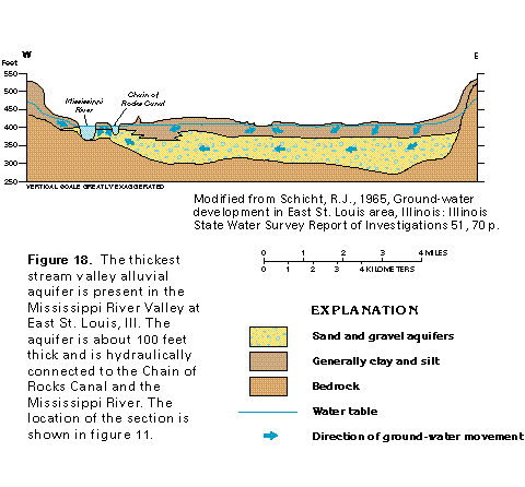
The sand and gravel aquifers of the surficial aquifer system are present in different hydrogeologic settings. Aquifers that consist of glacial deposits are in buried river valleys, such as the Mahomet Valley in central Illinois (fig. 15); glacial out-wash plains, such as the one in northern Lagrange County, Ind. (fig. 16); and ancestral river valleys, such as the one along the Great Miami River in Butler County, Ohio (fig. 17). The thick Quaternary sand and gravel deposits along the Mississippi River near East St. Louis, St. Clair County, Ill. (fig. 18), represent alluvium deposited by the ancestral Mississippi River. Much of this alluvium consists of eroded and reworked glacial deposits.
The occurrence and movement of the ground water is somewhat different in the four hydrogeologic settings shown in figures 15 through 18. In the buried bedrock valley setting (fig. 15), the shallow sand and gravel aquifers are isolated from direct recharge and discharge by overlying clay and silt deposits that compose local confining units. Under natural conditions, most of the water that recharges these shallow aquifers moves along short flow paths and discharges to local streams. The remainder of the water circulates into the deeper sand and gravel that fills the buried Mahomet Valley. Where wells withdraw water from the deeper sand and gravel aquifers, more of the recharge water is drawn into the deeper deposits. Water is transmitted rapidly to wells completed in the shallow, isolated sand and gravel aquifers, but the long-term yield of the wells is limited by the volume of recharge that passes through the surrounding clay and silt deposits. Small volumes of water might flow from bedrock into the sand and gravel aquifers.
In the glacial outwash plain setting (fig. 16), the sand and gravel aquifers commonly are at the land surface and receive recharge directly from precipitation. Under natural conditions, water in the upper part of the glacial deposits discharges to local streams, lakes, or wetlands; however, water in the deeper parts of the sand and gravel deposits flows beneath local streams and lakes and discharges to larger streams that are regional drains. Large yields are possible from wells completed in the glacial outwash aquifers, particularly where the aquifers have a direct hydraulic connection to streams and lakes and the wells are located near these surface-water bodies.
Parts of the hydrogeologic setting in figure 17 are similar to the settings illustrated by figures 15 and 16. The upper sand and gravel aquifer in figure 17A is recharged directly by precipitation and has a direct hydraulic connection to the Great Miami River, similar to the aquifer-lake connection shown in figure 16. This direct connection increases the potential for large volumes of recharge to move toward nearby pumping wells. The recharge is obtained partly by induced infiltration of water from the river. The deeper buried sand and gravel aquifers shown in figure 17B are isolated from direct recharge and discharge by overlying clay and silt confining layers, a situation similar to that shown in figure 15.
The sand and gravel deposits in the Mississippi River Valley (fig. 18) are somewhat isolated from direct recharge but have a direct hydraulic connection to the river. Under natural conditions, recharge percolates downward through clay and silt confining units and then mostly moves through the sand and gravel deposits to discharge at the river. Wells near the river capture some of the flow and also might obtain some water by induced infiltration of water from the river.
Published reports on the sand and gravel deposits of the surficial aquifer system indicate that individual units range from less than 1 to about 300 feet in thickness. The thickest aquifers shown in this chapter are in the glacial outwash plain (fig. 16) in northern Lagrange County, Ind., and in the buried Ma-homet Valley in central Illinois.
Generalized Ground-Water Movement
Although ground water in the surficial aquifer system is under water-table, or unconfined, conditions in many places, artesian, or confined, conditions exist in places where interbedded clay or silt compose local confining units. Together, water-table and artesian water levels compose the potentiometric surface of an aquifer. The difference in the altitude of the potentiometric surface over a unit horizontal distance is called the hydraulic gradient. Ground water moves through an aquifer in a direction generally parallel to the hydraulic gradient. The movement generally is perpendicular to the lines of equal altitude of the potentiometric surface.
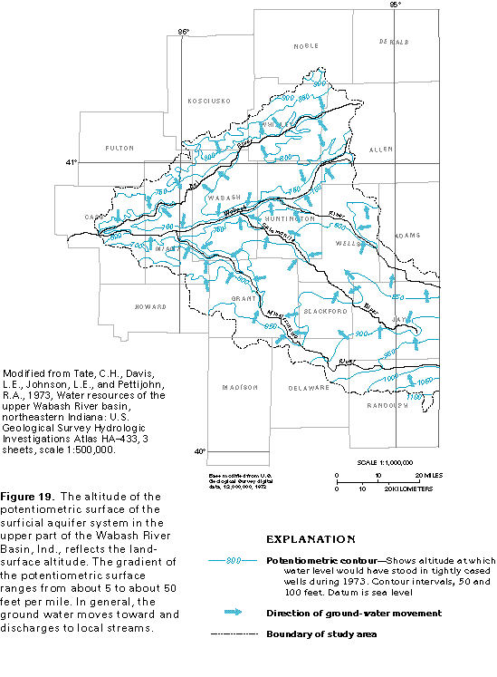
A local example of the configuration of the potentiometric surface of the surficial aquifer system and its relation to inter-stream recharge areas and stream-valley discharge areas is shown in figure 19. In this example, the altitude of the potentiometric surface in the upper part of the Wabash River Basin in northeastern Indiana ranges from less than 600 to more than 1,100 feet above sea level. The regional hydraulic gradient in the basin is about 5 feet per mile, whereas local gradients are as much as 50 feet per mile. The direction of ground-water movement shown in figure 19 is typical of that in the surficial aquifer system throughout the segment. Most of the water moves through the aquifer along short flow paths toward local streams where it is discharged to the streams as base flow. Some of the water follows longer flow paths in the deeper parts of the aquifer system and discharges to larger streams.
Aquifer Hydraulic Characteristics and Well Yields
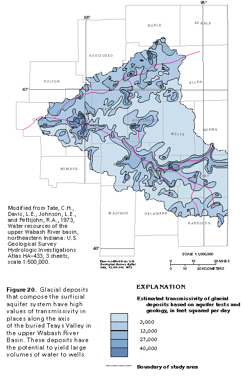
In parts of central and southern Ohio, the buried Teays Valley is filled with laminated clay and silt that are not aquifer material. Further to the north and west, in the upper part of the Wabash River Basin in Indiana, the valley is filled partly with sand and gravel. In western Indiana and central Illinois, sand and gravel aquifers have been mapped in and along the buried Teays-Mahomet Valley (fig. 11). These coarse, permeable materials allow water to move through the sediments with little resistance to flow. The capacity of an aquifer to transmit water is known as transmissivity, which is a way of measuring the relative ease with which water moves through the aquifer. Transmissivity values for the permeable sediments in the buried Teays Valley in the upper Wabash River Basin range from 3,000 to about 40,000 feet squared per day (fig. 20). The wa-ter moves more readily through the aquifer where the transmissivity is greatest.
The transmissivity of the surficial aquifer system varies through a wide range but generally is much larger than the transmissivity of underlying bedrock. Transmissivity values calculated for the surficial aquifer system range from less than 500 feet squared per day where the aquifer system is thin and contains fine-grained material to more than 50,000 feet squared per day where the aquifer system is thick and consists entirely of coarse-grained material. Transmissivity values of 5,000 to 25,000 feet squared per day are common where the thickness of the aquifer system ranges from 50 to 250 feet.
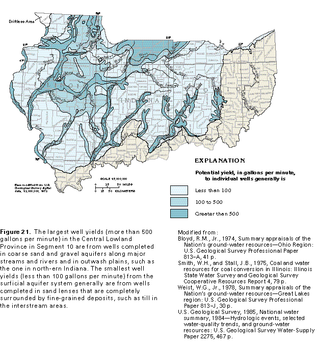
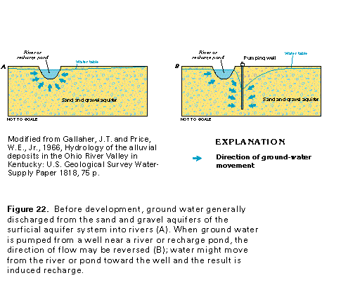
If all other factors remain the same, yields of wells completed in an aquifer are directly proportional to the transmissivity of the aquifer. The largest yields can be obtained from wells that are completed in aquifers which have the largest transmissivity values. The potential yield of wells completed in the surficial aquifer system in the Central Lowland Province in Segment 10 ranges from less than 100 to more than 500 gallons per minute (fig. 21). In general, the largest sustained potential yields are obtained from wells located in river valleys where the aquifers and the river are hydraulically connected. Under such conditions, large withdrawals from a well near a river will cause the water level in the well to decline until it is below river level. The gradient created will induce water to move from the river into the aquifer and toward the well (fig. 22). Under these conditions, well yields of 2,000 gallons per minute are common, and maximum yields might exceed 4,000 gallons per minute. In some places, recharge ponds have been constructed to capture and impound surface water. The impounded water percolates downward to recharge the surficial aquifer system and subsequently moves into nearby pumping wells.
Ground-Water Quality
The quality of water in the sand and gravel aquifers of the surficial aquifer system is similar throughout Illinois, Indiana, and Ohio. The quality of the ground water is such that the water generally is adequate or can be treated and made adequate for most uses. However, in some places in Illinois and Ohio, nitrate concentrations are larger than the maximum contaminant level of 10 milligrams per liter established by the U.S. Environmental Protection Agency for drinking water. These large nitrate concentrations are possibly due to contamination of the ground water by fertilizer or by septic tank effluent.
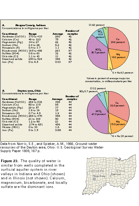
Water in the surficial aquifer system typically is a calcium magnesium bicarbonate type, is hard, and has large concentrations of iron (fig. 23). The water typically has a neutral pH. Concentrations of dissolved solids mostly range between about 250 and 750 milligrams per liter with a median concentration that approaches 500 milligrams per liter, which is the secondary maximum contaminant level recommended for drinking water by the U.S. Environmental Protection Agency (fig. 24). Median hardness concentrations, which are expressed as calcium carbonate, generally exceed 300 milligrams per liter. Most of the water contains iron concentrations of greater than 300 micrograms per liter, which causes the staining of laundry and porcelain plumbing fixtures. Concentrations of chloride and sulfate are generally less than 250 milligrams per liter, which is the secondary maximum contaminant level established by the U.S. Environmental Protection Agency for drinking water.
Fresh Ground-Water Withdrawals
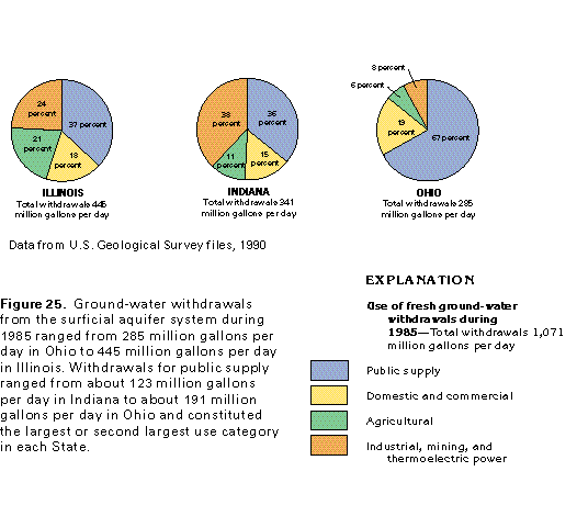
Approximately 2 billion gallons of fresh ground water was withdrawn each day during 1985 from all the aquifers in the Central Lowland Province in Segment 10. Of this amount, about 53 percent, or about 1.1 billion gallons per day, was withdrawn from the sand and gravel aquifers of the surficial aquifer system. About 445 million gallons per day was withdrawn from the surficial aquifer system in Illinois, 341 million gallons per day in Indiana, and 285 million gallons per day in Ohio (fig. 25). Withdrawals for public supply constituted the largest or second largest use category in each State, and accounted for about 165 million gallons per day in Illinois, 123 million gallons per day in Indiana, and 191 million gallons per day in Ohio. Large withdrawals were made for industrial, mining, and thermoelectric power use in Illinois and Indiana.
PENNSYLVANIAN AQUIFERS
Hydrogeologic Setting
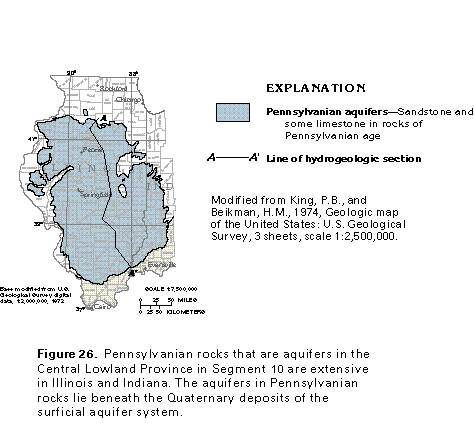
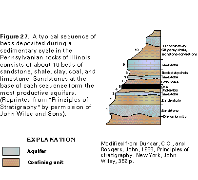
Sandstone and limestone beds of Pennsylvanian age that are aquifers in the Central Lowland Province in Segment 10 lie beneath the surficial aquifer system in parts of Illinois and Indiana (fig. 26). The Pennsylvanian sandstones and limestones are parts of repeating sequences of beds deposited during multiple sedimentary cycles. An ideal complete cycle consists of the following sequence of beds, listed from bottom to top: basal sandstone, sandy shale, limestone, underclay, coal, gray shale, limestone, black platy shale, limestone, and silty gray shale that contains iron concretions (fig. 27). The bottom five beds in the ideal sequence (including the coal) were deposited in a nonmarine environment. As the sea encroached upon the land, the upper five beds were deposited in a marine or marginal marine environment. Multiples of all or parts of this sequence were deposited by repeated advances and retreats of the sea. The main body of the sea was about as far west of Segment 10 during Pennsylvanian time as the present location of the State of Kansas. Sheetlike and channel-fill sandstones at the bases of the sedimentary sequences are some of the most productive aquifers in Pennsylvanian rocks. However, a zone of fractures, joints, and bedding plains commonly occurs in the upper parts of exposed Pennsylvanian rocks, and these openings yield water to wells regardless of rock type.
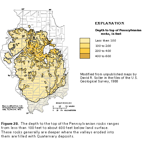
Small to moderate supplies of water are obtained from the Pennsylvanian aquifers in places where little water is available from the overlying Quaternary deposits of the surficial aquifer system. These conditions might exist where the Quaternary deposits are thin or fine grained or both. The Pennsylvanian aquifers commonly are used for water supplies in areas where they are buried beneath less than 100 feet of Quaternary deposits (fig. 28).
Most of the water in the Pennsylvanian aquifers is under confined conditions because the aquifers commonly are inter-bedded with siltstone, shale, and clay and are overlain by Qua-ternary deposits that contain clay beds. The water primarily moves through secondary openings, such as fractures and joints or local solution channels in limestones. Recharge to the Pennsylvanian aquifers takes place through the overlying Quaternary deposits. The large volumes of water stored in the sur-ficial aquifer system serve to replenish ground water withdrawn from wells completed in the Pennsylvanian aquifers. In some places, such as river valleys, water levels in the Pennsylvanian aquifers are higher than those in the overlying surficial aquifer system, and ground water moves from the Pennsylvanian aquifers to the surficial aquifer system.
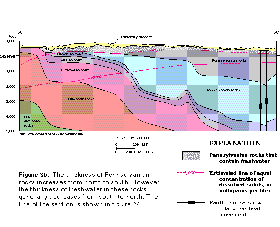
The thickness of Pennsylvanian rocks that is saturated with freshwater ranges from less than 100 feet to more than 300 feet (fig. 29). The thickest parts of the freshwater-yielding Pennsylvanian rocks are in central and southeastern Illinois and southwestern Indiana. Nearly the entire thickness of Pennsylvanian rocks contains freshwater in the north-central part of Illinois (fig. 30). Toward the south, the depth to saltwater decreases, and the Pennsylvanian rocks thicken. Near the southern limit of the area, only the upper 10 percent of the Pennsylvanian rocks contains freshwater.
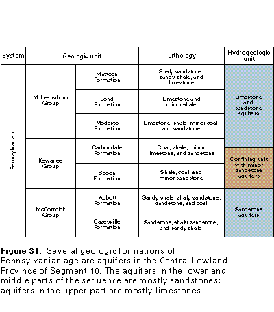
The sandstones and limestones that are the most productive aquifers in the Pennsylvanian rocks have a distinct stratigraphic (vertical) and areal distribution. Sandstones are the predominant aquifers in the lower parts of the sequence of Pennsylvanian rocks, whereas limestones are the predominant aquifers in the middle and upper parts of the sequence (fig. 31). The sandstone aquifers are saturated with freshwater only in peripheral parts of the area underlain by the Pennsylvanian rocks; elsewhere, they contain saltwater. Some of the limestones and shales of the middle and upper parts of the sequence grade into sandstones and silty sandstones in southeastern Illinois. Because these sandstones and silty sandstones commonly are channel-fill deposits, they are sinuous, thin, and discontinuous and might be difficult to locate.
Ground-Water Quality
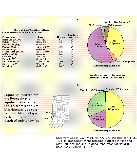
The quality of water obtained from the upper parts of the Pennsylvanian aquifers generally is similar throughout the area. However, pronounced water-quality changes occur with depth. Because the water-yielding sandstones and limestones are thin and are interlayered with thin, low-permeability deposits, such as shale and coal, the water withdrawn from these aquifers tends to be a composite water type, which reflects interaction of the ground water with several rock types that contain different minerals. Dissolved-solids concentrations in water from the Pennsylvanian aquifers increase with increasing depth, but in the freshwater parts of the aquifers, the water is softened somewhat by ion exchange between the water and minerals in the shales and clays. Typically, the water from the freshwater parts of the Pennsylvanian aquifers is moderately hard and is a sodium bicarbonate type with a median dissolved-solids concentration that is slightly greater than 500 milligrams per liter (fig. 32A). The increase in concentration of dissolved solids with increasing depth primarily is due to increases in the concentrations of sodium and chloride in the water. These constituents are present in the saltwater and brine in the deep parts of the Pennsylvanian aquifers.
Mixing of freshwater with the saltwater results in a water that is a sodium chloride type, such as the water represented by figure 32B. The change in water from a sodium bicarbonate type to a sodium chloride type, accompanied by a large increase in dissolved-solids concentrations, takes place with small changes in depth. Concentrations of calcium, magnesium, and bicarbonate are larger in water from the shallower parts of the Pennsylvanian aquifers. Large concentrations of fluoride (as much as 15 milligrams per liter) locally are pres-ent. In some instances, the fluoride content of the water is great enough to mottle the teeth of persons who drink it on a continual basis.
Well Yields and Fresh Ground-Water Withdrawals
Yields of wells completed in the Pennsylvanian aquifers have been reported to range from less than 1 to about 100 gallons per minute. The average well yield is about 10 gallons per minute.
Fresh ground-water withdrawals from the Pennsylvanian aquifers are relatively small. Withdrawals from these aquifers during 1985 were less than 4 percent of the total withdrawals in Illinois and less than 1 percent of the total withdrawals in Indiana.
MISSISSIPPIAN AQUIFERS
Hydrogeologic Setting
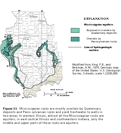
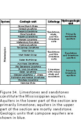
Mississippian rocks that are aquifers in the Central Low-land Province in Segment 10 lie beneath Quaternary deposits and Pennsylvanian rocks in parts of western Illinois, eastern Illinois, and southwestern Indiana (fig. 33). Generally, thick-bedded limestones and sandstones constitute the aquifers. Although small amounts of water can be obtained from nearly all the Mississippian rocks, including shale, in the areas shown in figure 33, the most productive water-yielding rocks are limestones and sandstones. Limestone is the dominant rock type in the lower one-half of the Mississippian section (fig. 34), whereas sandstone is more abundant in the upper one-half. Some of the limestone formations in the lower part of the Mississippian rocks in western Illinois change to shale in the eastern part of the area. Thus, almost all the Mississippian rocks are considered to be aquifers in western Illinois, whereas only the middle and upper parts of Mississippian rocks are considered to be aquifers in eastern Illinois and southwestern Indiana.
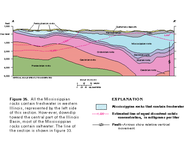
Freshwater circulates to depths greater than 1,000 feet below sea level in west-central Illinois; consequently, all the Mississippian rocks that are directly overlain by Quaternary deposits and some that are directly overlain by Pennsylvanian rocks contain freshwater in this area (fig. 35). However, in southern Illinois and in areas toward the central part of the Illinois Basin, Mississippian rocks are at greater depths and are overlain by a thick, continuous sequence of Pennsylvanian rocks that impedes deep freshwater circulation. In addition, some of the Mississippian limestones grade eastward to less-permeable shale. Downdip toward the central part of the Illinois Basin, initially part and eventually all the Mississippian rocks contain water with dissolved-solids concentrations of greater than 1,000 milligrams per liter.
The distribution of wells that obtain water from the Mississippian aquifers is similar to that of wells completed in the Pennsylvanian aquifers. The Mississippian aquifers generally are used for water supply where they are less than 200 feet below land surface and where more water can be obtained from them than from the overlying surficial aquifer system.
Water in the Mississippian aquifers primarily moves through openings such as bedding planes, fractures, and solution channels. Generally, the water is under confined conditions where the water-yielding zones in the Mississippian rocks lie beneath clay or shale beds. Recharge to the Mississippian aquifers occurs primarily by water that percolates downward through the overlying Quaternary deposits and Pennsylvanian rocks. Water discharges to these younger rocks in places where the water level in the Mississippian aquifers is higher than that in the overlying aquifers. Water stored in the overlying rocks, especially the Quaternary deposits, serves to replenish ground water withdrawn from the Mississippian aquifers.
Ground-Water Quality
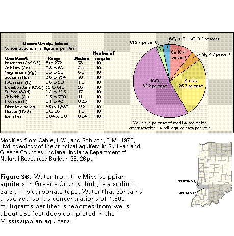
A summary of the results of chemical analyses of water from wells completed in the Mississippian aquifers in Greene County, Ind., on the eastern side of the Illinois Basin is shown in figure 36. The water is moderately hard and is a sodium calcium bicarbonate type. Water from wells deeper than 200 feet in Greene County can have concentrations of sulfate and chloride that exceed 250 milligrams per liter and dissolved solids that exceed 500 milligrams per liter. Sparse data indicate that water from the Mississippian aquifers in western Illinois is very hard, which reflects the predominance of limestone in this area. Slightly acidic ground water partially dissolves the limestone, thus increasing the concentration of calcium and magnesium ions (primary hardness-causing constituents) in the water.
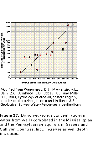
Water quality and well-depth data from the Mississippian and the Pennsylvanian aquifers in Greene and Sullivan Counties, Ind., indicate that small increases in well depth are accompanied by large increases in dissolved-solids concentrations (fig. 37). Wells shallower than 160 feet yield water that contains less than 500 milligrams per liter dissolved solids; water from deeper wells has dissolved-solids concentrations as large as 3,400 milligrams per liter. At shallow depths, the water generally is hard and is a calcium bicarbonate type or a calcium sodium bicarbonate type, whereas water from deep wells in the Mississippian aquifers might be a sodium chloride type.
Well Yields and Fresh Ground-Water Withdrawals
The reported yields of wells completed in the Mississippian aquifers range from less than 1 to more than 100 gallons per minute; the average well yield is about 10 gallons per minute. Properly completed and developed wells commonly yield from 20 to 30 gallons per minute. The largest volumes of water are obtained from wells that penetrate large openings in the rocks, such as bedding planes, fractures, and solution openings.
The specific capacity (well yield divided by water-level drawdown during pumping) of wells completed in the Mississippian aquifers generally ranges from 0.03 to 9 gallons per minute per foot of water-level drawdown (fig. 38). The specific capacity generally is greater for some Mississippian formations than others. Wells completed in the Keokuk and the Burlington Limestones generally have the largest specific capacities, and those completed in the Ste. Genevieve, the St. Louis, and the Salem Limestones and the shale and limestone of the Warsaw Formation generally have the smallest specific capacities.
Fresh ground-water withdrawals from the Mississippian aquifers during 1985 were less than 3 percent of the total ground water withdrawn in Illinois. Withdrawals from Mississippian aquifers in Indiana during the same period were less than 1 percent of the total ground water withdrawn.
Hydrogeologic Setting
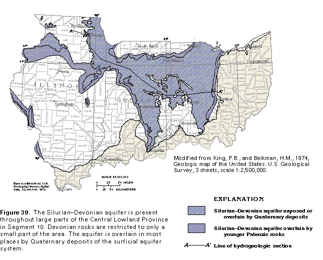
Dolomites and limestones of Silurian and Devonian age constitute one of the principal consolidated-rock aquifers throughout a large area in the Central Lowland Province in Segment 10 (fig. 39). The Silurian-Devonian aquifer lies beneath Upper Devonian shales, Mississippian rocks, or Quaternary deposits and is present from central Ohio across Indiana into northern and western Illinois.
The Silurian-Devonian aquifer has been referred to by a number of different names. It is known as the carbonate aquifer in Ohio, the Silurian-Devonian aquifers in Indiana, and the upper part of the shallow dolomite aquifer in Illinois. The aquifer was designated the "Silurian-Devonian aquifer" by a regional aquifer study that encompassed northern Illinois, Iowa, Wisconsin, and Minnesota. Because the name "Silurian-Devonian aquifer" has been applied regionally, this name is used in this chapter.
The Devonian rocks are less important hydrologically than the Silurian rocks because much of the lower part of the section of Devonian rocks has been removed from most of the area by erosion (fig. 40). Consequently, the Devonian parts of the aquifer are mainly in narrow bands in Ohio, Indiana, and eastern Illinois. Only in a small area in northwestern Indiana do Devonian carbonate rocks completely cover the freshwater-yielding Silurian carbonate rocks.
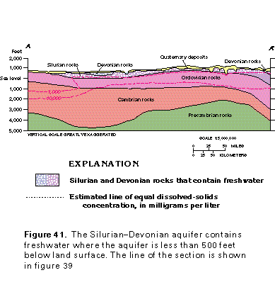
In northern Illinois, freshwater is present at depths greater than 1,000 feet below sea level, which is much deeper than the bottom of the Silurian-Devonian aquifer (fig. 41). However, to the south and east (throughout most of the area shown in color in figure 39), the Silurian-Devonian aquifer generally contains freshwater where the aquifer is between land surface and about 500 feet below land surface. The base of freshwater approximately coincides with the base of the aquifer in most places. The underlying Upper Ordovician shales impede the downward movement of freshwater. The Silurian-Devonian aquifer contains freshwater for only a short distance from where it is overlain by Upper Devonian shales in Ohio, Indiana, and eastern Illinois. These overlying shales impede the downward movement of freshwater into the aquifer. In western and northwestern Illinois where the Silurian-Devonian aquifer is covered by Mississippian rocks, the extent of freshwater beneath the younger rocks is greater.
Most of the freshwater part of the Silurian-Devonian aquifer is directly overlain by unconsolidated deposits of Quaternary age that compose the surficial aquifer system. The thickness of the Quaternary deposits and, consequently, the depth to the top of the Silurian-Devonian aquifer range from less than 100 feet to more than 400 feet below land surface in the area. The Silurian-Devonian aquifer is most commonly used for water supply where it is overlain by less than 200 feet of Quaternary deposits.
Ground water generally is under confined conditions in the Silurian-Devonian aquifer. The water moves through fractures, bedding planes, and solution cavities in the dolomites and limestones. The Silurian-Devonian aquifer is recharged from the overlying surficial aquifer system in areas where water levels in the surficial aquifer system are higher than those in the Silurian-Devonian aquifer. Locally, where the water-level differences are reversed, water discharges to the surficial aquifer system from the Silurian-Devonian aquifer. The water stored in the surficial aquifer system serves to replenish the water withdrawn from wells that are completed in the underlying Silurian-Devonian aquifer.
Well Yields
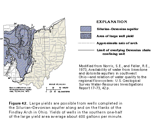
The yields of wells completed in the Silurian-Devonian aquifer range from less than 5 to more than 1,000 gallons per minute. Yields of 5 to 15 gallons per minute can be obtained from most wells completed in the aquifer throughout the area shown in figure 39. Large well yields are possible locally in Illinois, Indiana, and Ohio, but the largest well yields, more than 1,500 gallons per minute, are reported from northern Illinois.
Large well yields in Ohio are possible in the west-central and northwestern parts of the State (fig. 42). Middle and Upper Silurian dolomites are the major water-yielding rocks in this area due to the dissolving action of slightly acidic recharge water on these carbonate rocks where they are exposed or thinly covered along the flanks and part of the axis of the Findlay Arch. The specific capacities of large-diameter test wells were used to define the areas of large yield shown in figure 42. The specific capacities of these wells range from 5 to 106 gallons per minute per foot of water-level drawdown, and average about 30 gallons per minute per foot of drawdown. The average yield for wells located in the southern one-half of the area of large yield is about 600 gallons per minute and the average yield for wells in the remainder of the large-yield area is about 450 gallons per minute. Specific capacities of large-diameter test wells located outside the area of large yield shown in figure 42 range from less than 0.5 to 5 gallons per minute per foot of water-level drawdown and average about 2.2 gallons per minute per foot of drawdown. The yield of these wells ranges from about 160 to 260 gallons per minute.
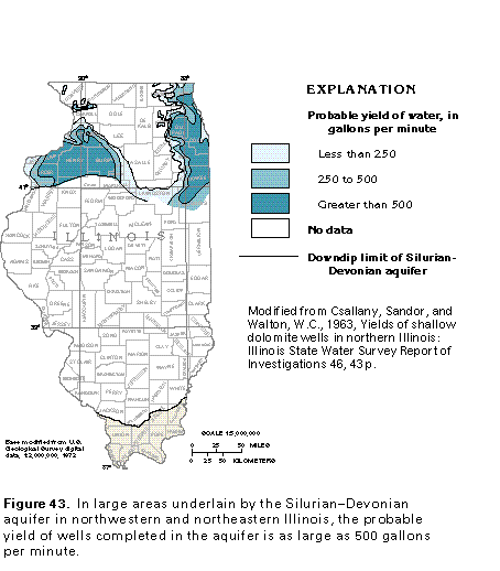
The estimated yield of wells completed in the Silurian-Devonian aquifer in northern Illinois is shown in figure 43. Well yields in the area are highly variable and might be 1 gallon per minute or less. However, analysis of specific-capacity data for wells in the area indicates that well yields of 250 gallons per minute or more are probable throughout most of the area, and well yields of 500 gallons per minute are probable in large parts of northeastern and northwestern Illinois. The wells with large yields generally are completed in the upper one-third of Silurian rocks. Larger yields also coincide with places where the bedrock surface is locally at higher altitudes than surrounding areas and where the Silurian rocks are overlain by Quaternary sand and gravel deposits.
Ground-Water Quality
The chemical quality of water from the freshwater parts of the Silurian-Devonian aquifer generally is adequate or can be treated and made adequate, for most purposes. Concentrations of dissolved solids and iron exceeded secondary maximum contaminant levels established by the U.S. Environmental Protection Agency in more than 50 percent of the studied samples (fig. 44). In addition, the water is hard, and sulfate concentrations exceed 250 milligrams per liter in many samples. Generally, chloride concentrations are less than 250 milligrams per liter where the aquifer is directly overlain by the surficial aquifer system. However, chloride concentrations might be greater than 250 milligrams per liter downdip, particularly where the aquifer is overlain by Devonian, Mississippian, or Pennsylvanian shales, which impede deep freshwater circulation.
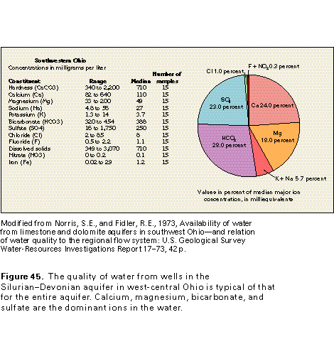
An example of the major dissolved constituents in water from the Silurian-Devonian aquifer is shown in figure 45. In samples from western Ohio, calcium, magnesium, bicarbonate, and sulfate are the most common ions. The large concentrations of calcium and magnesium probably are derived primarily from the dolomite (calcium magnesium carbonate) through which the water moves. The water is a calcium magnesium bicarbonate type in recharge areas and a calcium magnesium sulfate type in discharge areas (fig. 46).
Fresh Ground-Water Withdrawals
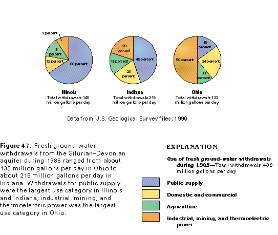
Total fresh ground-water withdrawals from the Silurian-Devonian aquifer in Illinois, Indiana, and Ohio were about 488 million gallons per day during 1985. About 95 percent of this water was withdrawn from wells completed in the aquifer in the Central Lowland Physiographic Province. The remainder came from wells located in southernmost Illinois and Ohio in the In-terior Low Plateaus Province. Water withdrawn from the Silurian-Devonian aquifer was about 21 percent of the total ground water withdrawn for all three States during 1985. The withdrawals from the Silurian-Devonian aquifer were about 15 percent of the total ground water withdrawn in Illinois, 18 percent in Ohio, and 34 percent in Indiana.
The volume of water withdrawn for some of the ground-water use categories changes significantly from State to State (fig. 47). Ground-water withdrawals from the Silurian-Devonian aquifer for public supply during 1985 were about 92 million gallons per day in Illinois, 97 million gallons per day in Indiana, and 20 million gallons per day in Ohio. Public supply was the largest use category in Illinois and Indiana. In Ohio, about 67 million gallons per day were withdrawn for industrial, mining, and thermoelectric power use, the largest use category in the State.
CAMBRIAN-ORDOVICIAN AQUIFER SYSTEM
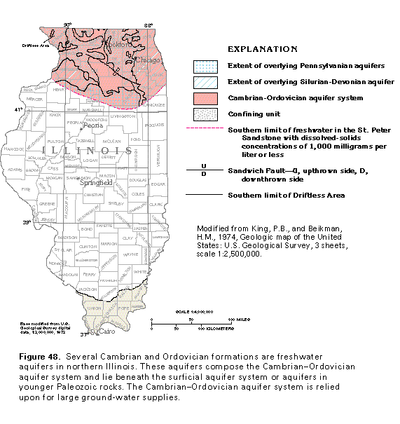
The aquifers in rocks of Cambrian and Ordovician age and the confining units that separate and overlie them are collectively known as the Cambrian-Ordovician aquifer system. Where this aquifer system is buried beneath Silurian and Devo-nian rocks in the Central Lowland Province in Segment 10, it is separated from the overlying Silurian-Devonian aquifer by the Maquoketa confining unit, which consists of Upper Ordovician shale, dolomite, and dolomitic shale. Where the Maquoketa confining unit and younger Paleozoic rocks have been removed by erosion, the Cambrian-Ordovician aquifer system is overlain by the surficial aquifer system, except in the Driftless Area in northwestern Illinois where the Cambrian-Ordovician aquifer system is exposed at the land surface. The Cambrian-Ordovician aquifer system is underlain by low-permeability Precam-brian crystalline rock throughout the Central Lowland Province.
The Cambrian-Ordovician aquifer system is complex and multilayered; major aquifers are separated by leaky confining units. Large withdrawals in the Chicago, Ill., and Milwaukee, Wis., areas have created deep, extensive cones of depression in the potentiometric surface of the aquifer system. The Cambrian-Ordovician aquifer system is a major source of water supply in Segment 9 and is discussed in greater detail in the chapter of this Atlas that describes that segment.
The Cambrian-Ordovician aquifer system contains freshwater in a large area in northern Illinois (fig. 48). The freshwater flow systems within individual aquifers are partially isolated from one another by leaky confining units that separate the aquifers. Freshwater circulates to great depths in northern Illinois because of the high permeability of the Cambrian-Ordovician aquifer system and the large amount of recharge that enters the system where the rocks crop out or subcrop around the Wisconsin Arch to the northwest.
Water in the Cambrian-Ordovician aquifer system primarily is under confined conditions and moves through primary and secondary openings in the rocks. The primary openings consist of bedding planes and the voids between the grains that compose the sandstones; the secondary openings consist of fractures and bedding planes in the clastic rocks and fractures and solution channels in the carbonate rocks.
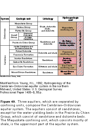
Parts of three principal aquifers, which consist of consolidated rocks of Ordovician and Cambrian age, are present in northern Illinois-the St. Peter-Prairie du Chien-Jordan, the Ironton-Galesville, and the Mount Simon (fig. 49). These aquifers extend into northern Illinois from Wisconsin and Iowa. The Jordan Sandstone of Late Cambrian age is a major part of the St. Peter-Prairie du Chien-Jordan aquifer in Wisconsin and Iowa, but in Segment 10, this sandstone is part of the aquifer only in western Illinois. The relations among the three principal aquifers and their associated overlying and underlying confining units are shown in a hydrogeologic section from Stephenson County, Ill., to Howard County, Ind. (fig. 50).
St. Peter-Prairie du Chien-Jordan Aquifer
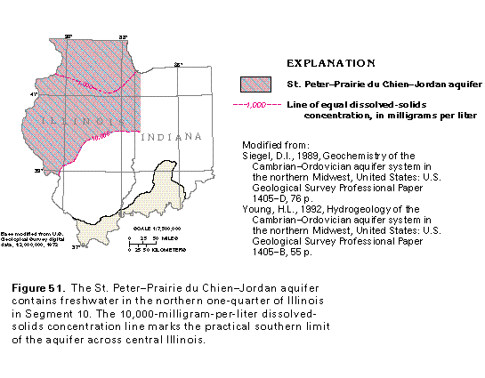
The St. Peter-Prairie du Chien-Jordan aquifer lies beneath the Maquoketa, the Galena, and the Platteville Groups, which primarily are shale, dolomitic shale, and dolomite of low permeability. The aquifer consists of the fine- to medium-grained, well-sorted, friable St. Peter Sandstone; the sandy, cherty dolomites of the Prairie du Chien Group; and the fine- to coarse-grained, dolomitic Jordan Sandstone. These rocks contain freshwater in the northern one-fourth of Illinois. The practical southern boundary of the aquifer is marked by a line that traverses the State in a northeast-southwest direction (fig. 51) and represents water in the aquifer with dissolved-solids concentrations of 10,000 milligrams per liter. This is considered to be the practical limit of the aquifer because ground-water movement downgradient of the line is minimal. Although the Jordan Sandstone is a major part of the aquifer in Iowa and Wisconsin, the Jordan is present in only a small part of western Illinois in Segment 10.
The top of the St. Peter-Prairie du Chien-Jordan aquifer is more than 500 feet above sea level in the northernmost part of Illinois and about 2,500 feet below sea level in central Illinois (fig. 52). The average altitude of the top of the aquifer is about 250 feet above sea level in the area where the aquifer contains freshwater. The slope of the top of the aquifer generally is southward into the Illinois Basin.
The St. Peter-Prairie du Chien-Jordan aquifer is about 250 feet thick along the northern boundary of Illinois and about 1,250 feet thick in west-central Illinois. The thickness averages about 400 feet in the area where the aquifer contains freshwater. The aquifer is thinnest in northern Illinois where the rocks of the Prairie du Chien Group were completely eroded away before the deposition of the St. Peter Sandstone.
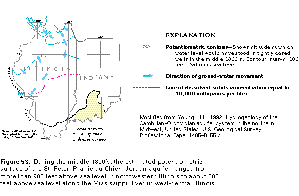
Before substantial volumes of ground water were withdrawn from the Cambrian-Ordovician aquifer system, water levels in the St. Peter-Prairie du Chien-Jordan aquifer are estimated to have ranged from more than 900 feet above sea level in parts of northern Illinois to about 500 feet above sea level along the Mississippi River in west-central Illinois (fig. 53). The direction of ground-water movement, as shown by the arrows on figure 53, was from upland recharge areas toward discharge areas at major streams and Lake Michigan.
Ironton-Galesville Aquifer
The Ironton-Galesville aquifer is separated from the overlying St. Peter-Prairie du Chien-Jordan aquifer by dolomite and poorly sorted, fine-grained clastic rocks of the Franconia Formation and the Potosi Dolomite (fig. 49). These low-permeability rocks are collectively known as the Franconia confining unit in northern Illinois.
The Ironton-Galesville aquifer consists of the Ironton and the Galesville Sandstones of Cambrian age. These units are lithologically similar and generally consist of fine- to coarse-grained quartzose sandstone. They compose the most productive aquifer of the Cambrian-Ordovician aquifer system in northeastern Illinois and yield much of the ground water withdrawn in the Chicago area.
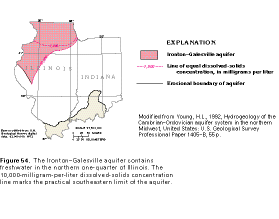
The sandstones of the Ironton-Galesville aquifer were not deposited to the southwest of a line that marks the limit of the aquifer in west-central Illinois (fig. 54). In central and eastern Illinois, the line that represents water in the aquifer that contains dissolved-solids concentrations of 10,000 milligrams per liter marks the practical limit of the aquifer.
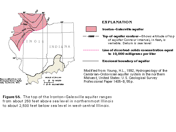
The top of the Ironton-Galesville aquifer slopes from about 250 feet above sea level in northernmost Illinois to about 2,500 feet below sea level in the west-central part of the State (fig. 55). The average altitude of the top of the aquifer in Illinois is about 1,000 feet below sea level. The thickness of the aquifer ranges from more than 200 feet southwest of Chicago to zero at the depositional limit. The average thickness of the aquifer is about 150 feet in northern Illinois.
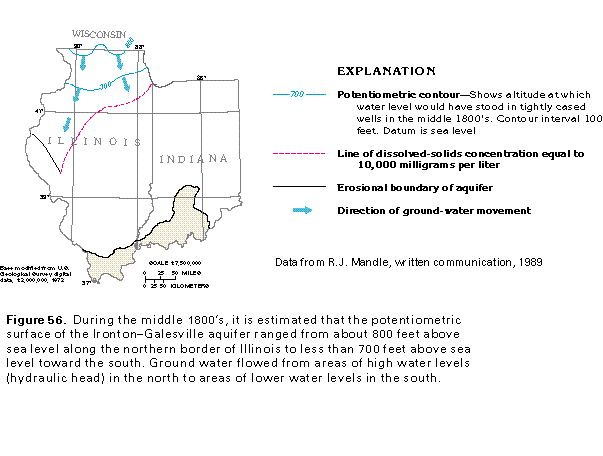
Estimated water levels (hydraulic head) for the Ironton-Galesville aquifer before the development of substantial ground-water supplies from the Cambrian-Ordovician aquifer system are shown in figure 56. Water levels were about 800 feet above sea level along the northern border of Illinois and less than 700 feet above sea level in the southern part of the area. Water levels were slightly higher in the Ironton-Galesville aquifer than those in the deeper Mount Simon aquifer along the Illinois-Wisconsin State line. Ground-water flow in the Ironton-Galesville aquifer generally was southward toward the Illinois Basin from recharge areas in Wisconsin.
Mount Simon Aquifer
The Mount Simon aquifer underlies the northern part of Illinois and the northwestern part of Indiana in Segment 10. It is separated from the Ironton-Galesville aquifer by low-permeability siltstones and shales of the Eau Claire Formation. These low-permeability rocks are known as the Eau Claire confining unit (fig. 49).
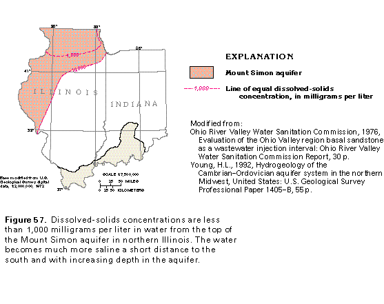
The Mount Simon aquifer consists of sandstone that contains water with a wide range of concentrations of dissolved solids (fig. 57). In Segment 10, only the upper part of the aquifer in northern Illinois contains freshwater. Dissolved-
solids concentrations increase with depth (fig. 50) and toward the south and east. The line that shows dissolved-solids concentrations of 10,000 milligrams per liter on figure 57 marks the practical southern limit of the aquifer.
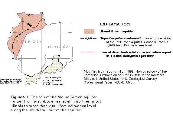
The top of the Mount Simon aquifer ranges from slightly above sea level to more than 2,000 feet below sea level (fig. 58). The depth to the top of the aquifer decreases toward the north; the aquifer crops out on the flanks of the Wisconsin Arch in Wisconsin. The average depth to the top of the aquifer in northern Illinois is about 800 feet below sea level.
The thickness of the Mount Simon aquifer in northern Illinois ranges from slightly less than 1,000 feet in northernmost Illinois to more than 2,500 feet southwest of Chicago. The average thickness is between 1,500 and 2,000 feet. The Mount Simon aquifer is by far the thickest aquifer in the Cambrian-Ordovician aquifer system in Segment 10.
Estimated hydraulic heads (water levels) in the Mount Simon aquifer before substantial ground-water supplies were developed from the Cambrian-Ordovician aquifer system in northern Illinois are shown in figure 59. The predevelopment potentiometric surface is estimated to have been more than 800 feet above sea level northwest of Chicago and less than 700 above sea level to the east, south, and west. Ground-water movement was away from the high hydraulic heads (high water levels) toward lower heads (lower water levels) present along major rivers and Lake Michigan.
Ground-Water Quality
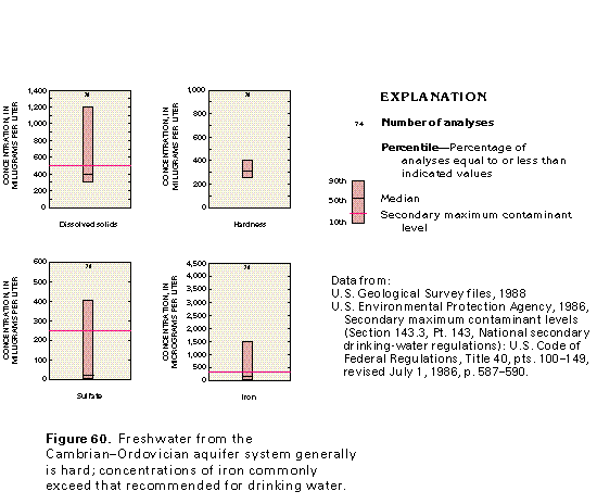
Most of the data on the quality of water from the Cambrian-Ordovician aquifer system in northern Illinois are from wells that are open to more than one aquifer in the system. Thus, the data represent the average quality of water from the entire system. The quality of water from the Cambrian-Ordovician aquifer system in northern Illinois generally is suitable for most uses. However, the water commonly is hard and might contain concentrations of dissolved solids, sulfate, and iron that exceed secondary maximum contaminant levels established by the U.S. Environmental Protection Agency for drinking water (fig. 60).
Water from 74 wells completed in the Cambrian-Ordovician aquifer system in northern Illinois had concentrations of dissolved solids that ranged from about 260 to 1,180 milligrams per liter, concentrations of hardness-causing constituents that ranged from about 250 to 420 milligrams per liter, sulfate concentrations that ranged from less than 10 (detection limit) to about 400 milligrams per liter, and iron concentrations that ranged from less than 50 (detection limit) to about 2,000 micrograms per liter (fig. 60).
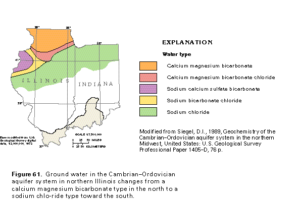
The composite water that represents the Cambrian-Ordovician aquifer system is a calcium magnesium bicarbonate type in northern Illinois (fig. 61). Toward the south where the aquifers are deeply buried, the water changes to a calcium magnesium bicarbonate chloride type; to the southwest, it changes to a sodium bicarbonate chloride type as it moves down the hydraulic gradient. Still further downgradient, the water changes to a sodium chloride type. Sulfate is one of the dominant dissolved constituents of the water in the aquifer system in a small part of west-central Illinois.
Fresh Ground-Water Withdrawals
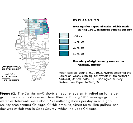
Major areas of ground-water withdrawal from the Cambrian-Ordovician aquifer system in northern Illinois are shown in figure 62. The areas of largest withdrawal are near Chicago.
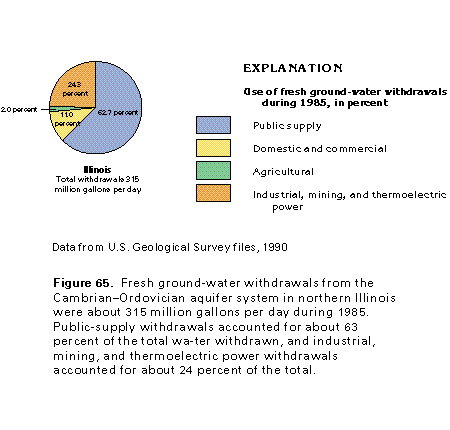
About 260 million gallons per day were withdrawn from the Cambrian-Ordovician aquifer system in northern Illinois during 1980. Of this amount, 68 percent, or about 177 million gallons per day, was withdrawn in an eight-county area around Chicago. The increase in water use from 1864 to 1980 in this area is shown in figure 63. Total ground-water withdrawals from the Cambrian-Ordovician aquifer system in northern Illinois were about 315 million gallons per day during 1985. It is estimated that the 1985 withdrawals from the aquifer system were about three times the recharge rate.
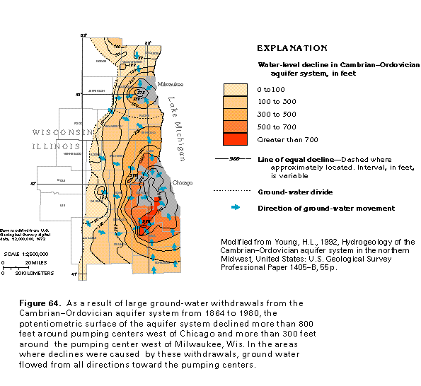
As a result of withdrawals in the Chicago, Ill., and Milwaukee, Wis. areas, the potentiometric surface of the Cambrian-Ordovician aquifer system had declined more than 800 feet by 1980 in the pumping centers west of Chicago, and more than 300 feet in the pumping center west of Milwaukee (fig. 64). The large cones of depression around these pumping centers spread westward and northwestward to areas where the Ma-quoketa confining unit is absent. Where this confining unit has been removed by erosion, the upper part of the Cambrian-Ordovician aquifer system is in direct contact with the overlying surficial aquifer system in north-central Illinois and southeastern Wisconsin. Where the two systems are in contact, the Cambrian-Ordovician aquifer system received large amounts of recharge from the shallower system, thus limiting the spread of the cones of depression. Beginning in the mid-1980's, withdrawals from the Cambrian-Ordovician aquifer system declined as some users switched to water from Lake Michigan as a source of supply. Water levels in the aquifer system had begun to rise by 1985 as a result of the decreased withdrawals.
Fresh ground-water withdrawals from the Cambrian-Ordovician aquifer system totaled 315 million gallons per day during 1985. About 197 million gallons per day was withdrawn for public supply and about 77 million gallons per day was withdrawn for industrial, mining, and thermoelectric power purposes. Withdrawals for commercial and domestic needs were nearly 35 million gallons per day, and about 6 million gallons per day was withdrawn for agricultural purposes (fig. 65).