INTRODUCTION
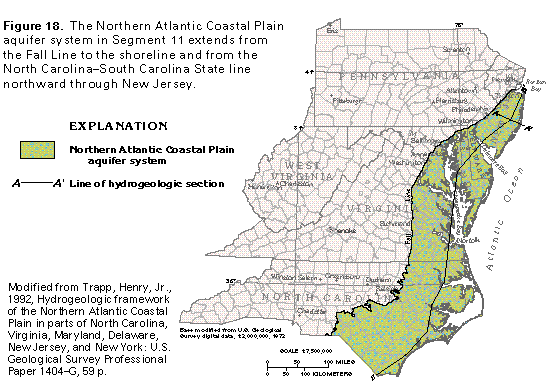
The Northern Atlantic Coastal Plain aquifer system consists of six regional aquifers in sedimentary deposits that range in age from Early Cretaceous to Holocene. The aquifer system underlies an area of about 50,000 square miles in Segment 11 and extends from the North Carolina-South Carolina State line northward to Raritan Bay, N.J. (fig. 18). The western limit of the aquifer system is the landward edge of water-yielding Coastal Plain strata where they pinch out against crystalline rocks of the Piedmont Physiographic Province at the Fall Line. Although the aquifers included in the aquifer system extend beneath the Atlantic Ocean and, in places, contain brackish water or freshwater under nearshore parts of the Continental Shelf, the eastern limit of the aquifer system is, for all practical purposes, the shoreline. The Northern Atlantic Coastal Plain aquifer system grades southward into the Southeastern Coastal Plain aquifer system, which is described in Segments 5 and 6 of this Atlas; the part of the coastal plain that underlies Long Island is described in Segment 12.
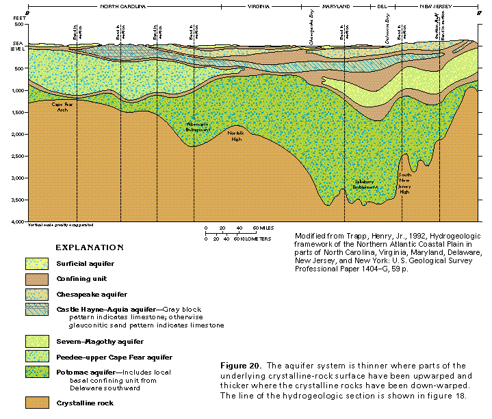
The northern part of the Atlantic Coastal Plain is underlain by a wedge-shaped mass of semi-consolidated to unconsolidated sediments that thickens toward the ocean and restson a surface of crystalline rock (fig. 19). The thickness of the sediments shown in figure 19 at the New Jersey coastline is about 4,000 feet, but the sediments attain thicknesses of as much as 8,000 feet along the coast of Maryland and 10,000 feet along the coast of North Carolina. The sediments consist of lenses and layers of clay, silt, and sand, with minor amounts of lignite, gravel, and limestone. The sand, gravel, and limestone compose aquifers of varying extent; some are traceable over long distances, whereas others are local. The aquifers are separated by confining units of clay, silt, and silty or clayey sand. Although water moves more readily through the aquifers than through the confining units, water can leak through the confining units, especially where they are thin or where they contain sand; the aquifers, therefore, are hydraulically interconnected to some degree.
The aquifers and confining units that underlie the Coastal Plain vary considerably in thickness (fig. 20). Much of this variation is because the sediments that contain these hydrologic units were deposited on an irregular crystalline-rock surface that was warped by tectonic forces so as to form arches that alternate with troughs or embayments. The three areas where the crystalline rock is arched upward in figure 20 are, from left to right, the Cape Fear Arch and the Norfolk and the South New Jersey Highs. The intervening downwarped areas, from left to right, are the Albemarle and the Salisbury Embayments. The arches were not always upwarped, however, nor were the embayments always downwarped. For example, the sediments that compose the Peedee-upper Cape Fear aquifer are thicker atop the Cape Fear Arch than in the Albemarle Embayment. This indicates that the Cape Fear Arch was downwarped during the time that the sediments that compose this aquifer were deposited. Likewise, thinning of the sediments of the Severn-Magothy aquifer into the Salisbury Embayment indicates that the embayment was not downwarped while these sediments were accumulating. Potomac aquifer sediments thin across all the arches and thicken into all the embayments shown in figure 20, which indicates that the crystalline-rock surface had the same configuration when those sediments were deposited as it has now.
The sediments that compose the Northern Atlantic Coast-al Plain aquifer system were deposited in nonmarine, marginal marine, and marine environments. Lower Cretaceous sediments were deposited mostly by streams in alluvial and deltaic environments. From Late Cretaceous through early Ter-tiary time, a series of marine transgressions covered most of the Atlantic Coastal Plain, and shallow marine to marine environments prevailed. A general regression of the sea began during late Tertiary time, when nonmarine Miocene sediments were deposited in New Jersey and parts of Maryland. Post-Miocene sediments are mostly Quaternary nonmarine clastic rocks.
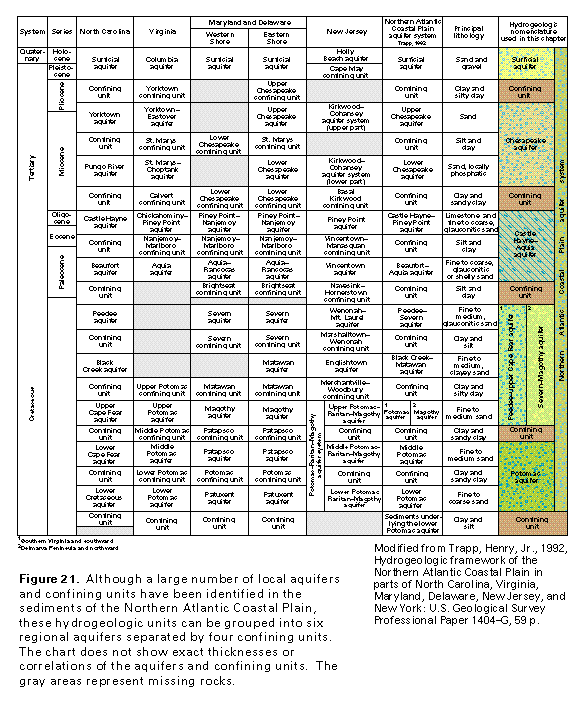
Interbedding of fine- and coarse-grained Coastal Plain sediments is complex because of shifting deltaic and alluvial deposition sites and because of repeated transgressions and regressions of the sea. Sediment types and textures, accordingly, can change greatly within short horizontal or vertical distances. Bodies of sand, gravel, or limestone can change facies laterally and become clayey or silty and, thus, less permeable. Therefore, many local aquifers can be identified, but these local aquifers can be grouped on the basis of similar hydrologic characteristics and treated as regional aquifers. Six regional aquifers separated by four regional confining units make up the Northern Atlantic Coastal Plain aquifer system (fig. 21).
Except for the surficial aquifer, which is named for its location at the land surface, the name applied to each regional aquifer is taken from one or more of the geologic formations or groups that compose the aquifer. The names chosen are taken from the geologic units that are the most widespread and (or) compose the more productive aquifers. Use of an aquifer name in a given State does not necessarily mean that the geologic formation from which the name is derived is recognized in that State. For example, the Potomac aquifer (fig. 21) is named for permeable sediments that are part of the Potomac Formation (or Group), which is a geologic name used in Virginia, Maryland, Delaware, and New Jersey. The Potomac aquifer also is mapped in North Carolina even though equivalent sediments there are called by different names. Combined aquifer names couple the name of the youngest, most extensive water-yielding formation with that of the oldest, most extensive water-yielding formation. An example is the Castle Hayne-Aquia aquifer in sediments of Oligocene through Paleocene age (fig. 21). The Castle Hayne Formation of North Carolina and the Aquia Formation of Virginia and Maryland form the most productive, most extensive parts of this regional aquifer.
VERTICAL SEQUENCE OF AQUIFERS
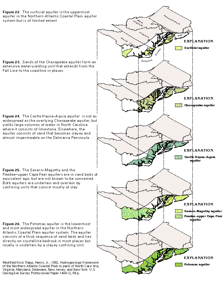
The Coastal Plain aquifers in Segment 11 are, in descending order, the surficial aquifer (fig. 22), the Chesapeake aquifer (fig. 23), the Castle Hayne-Aquia aquifer (fig. 24), the Severn-Magothy aquifer in the northern part of the segment (fig. 25), the Peedee-upper Cape Fear aquifer in the southern part (fig. 25), and the Potomac aquifer (fig. 26). The boundaries of the aquifers are irregular, as shown in these figures, and none of the aquifers extends over the whole Coastal Plain. The regional aquifers consist of various geologic formations and, in most places, are vertically separated by clayey or silty confining units that retard the vertical flow of ground water. The aquifers contain saline water in places, especially near the modern coastline, but they are mapped wherever the sediments that compose them are permeable, regardless of the chemical quality of the water in the sediments. The Castle Hayne-Aquia aquifer is absent in part of the Delmarva Peninsula (fig. 24) because the sand beds of the aquifer contain more clay and are less permeable toward the coast.
The surficial aquifer is the uppermost aquifer in the aquifer system (fig. 22). This aquifer consists of unconsolidated, locally gravelly sand, mostly of Quaternary age. Although a thin blanket of unconsolidated sediments makes up the uppermost Coastal Plain beds over wide areas, these sediments mostly are unsaturated or else yield little water to wells. The aquifer is mapped in figure 22 only in those areas where wells completed in the aquifer can be expected to yield at least 50 gallons per minute.
The Chesapeake aquifer (fig. 23) underlies the surficial aquifer in most places, but the two aquifers are separated by a clayey confining unit. The Chesapeake aquifer consists mostly of sand beds of Miocene age. Phosphate of mineable concentration is in sands of the aquifer in North Carolina.
The Castle Hayne-Aquia aquifer (fig. 24) underlies the Chesapeake aquifer; a clayey confining unit separates the two aquifers everywhere. In North Carolina, the Castle Hayne-Aquia aquifer is mostly limestone of the Castle Hayne Formation that produces large volumes of water. Further northward, the aquifer is mostly glauconitic sand.
The Severn-Magothy aquifer underlies the Castle Hayne-Aquia aquifer from New Jersey southward to the Delmarva Peninsula (fig. 25). The Peedee-upper Cape Fear aquifer, which is the southern equivalent of the Severn-Magothy aquifer, is present from southeastern Virginia to the North Carolina-South Carolina border. Both aquifers consist of fine to medium sand, and are overlain by a silt and clay confining unit. The Peedee-upper Cape Fear and the Severn-Magothy aquifers are absent in most of Virginia.
The Potomac aquifer (fig. 26) is the lowermost and most widespread aquifer of the aquifer system. The Potomac aquifer consists of fine to coarse sand beds and is separated from overlying aquifers everywhere by a confining unit of clay and sandy clay.
The surficial aquifer extends over large parts of the Del-marva Peninsula and the eastern coastal plain of North Carolina. Although thin surficial deposits yield small volumes of water to rural and domestic wells in a large part of the Coastal Plain, the surficial aquifer is defined as a principal Coastal Plain aquifer in this report only where it is capable of yielding at least 50 gallons of water per minute to wells or where the use of underlying aquifers is restricted because the deeper aquifers contain saline water. The surficial aquifer consists of unconsolidated sand and gravel of marine and nonmarine origin, depending on the locality. Many small-scale aquifers constitute the surficial aquifer.
The surficial aquifer consists of sand of Pleistocene age and beach and dune deposits of Holocene age on the Cape May Peninsula at the southern tip of New Jersey where the aquifer is underlain by a clay confining unit that separates it from the deeper Chesapeake aquifer. The surficial aquifer attains its greatest thicknesses in buried channels in the Del-marva Peninsula. Elsewhere in Segment 11, the average thickness of the aquifer is generally 50 feet or less. Near the Delaware-Maryland State boundary, the surficial aquifer directly overlies water-yielding beds of the Chesapeake aquifer. In that area, the combined beds act as a single aquifer.
The surficial aquifer contains water predominately under unconfined conditions, but clay beds locally create confined conditions. Almost all the flow within the aquifer is local; that is, water moves from recharge areas along short flow paths to discharge to the nearest stream or other surface-water body. Some water, however, percolates downward to recharge the underlying aquifers.
The transmissivity of the surficial aquifer (the rate at which water will move through the aquifer) is variable. Transmissivity values for the aquifer are generally less than 1,000 feet squared per day except on the Delmarva Peninsula where they are commonly 8,000 feet squared per day. Locally, the transmissivity of the aquifer is as much as 20,000 feet squared per day in buried channels in Delaware and 53,000 feet squared per day in a paleochannel in Maryland. The aquifer is very thick in the places where the transmissivity values are largest.
The quality of water in the surficial aquifer is variable and partly reflects the chemistry of the precipitation that recharges the aquifer. In precipitation, dissolved sodium and chloride concentrations tend to be greater, and dissolved sulfate concentrations tend to be less, nearer the coastline than inland. The chemical composition of the precipitation is modified as the water percolates downward through the soil zone and then moves through the aquifer where it reacts chemically with aquifer minerals. Because the water follows short flow paths, its residence time is short in the surficial aquifer, and the dissolution of minerals is limited.
Where the surficial aquifer adjoins the coast or saltwater estuaries and where it occurs on offshore islands, it is usually hydraulically connected to saline water. Hydraulic heads (water levels) in the aquifer are only slightly above sea level in these low-lying land areas, and the depth to saline water may be shallow as a result. The same low-lying areas tend to be natural discharge areas for the aquifers that underlie the surficial aquifer. The water that is discharged upward from the deeper aquifers tends to be hard and highly mineralized. In these areas, only water in the upper part of the surficial aquifer might be suitable for use.
Water in the surficial aquifer is especially susceptible to contamination by human activities because the aquifer is exposed at the land surface. For example, nitrogen and lime that are added to the soil during crop production can enter the water. Livestock wastes and septic-tank fields also produce nitrogen, the end product of which is nitrate in the ground water. Local contamination also can result from seepage from landfills, leakage from underground storage tanks, chemical spills, and infiltration of urban contaminants.
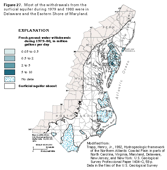
Ground-water withdrawals from the surficial aquifer in Segment 11 are greatest on the Delmarva Peninsula where sands of Holocene to Pliocene age and some gravel beds of Miocene age constitute the aquifer. The distribution of major pumping centers during 1979 and 1980, excluding irrigation, is shown in figure 27. The aquifer is used locally in Virginia for domestic and agricultural supplies, and withdrawals from the aquifer in North Carolina are principally for the same uses. South of Chesapeake Bay, the surficial aquifer is typically thinner or contains more clay than in the Delmarva Peninsula. In North Carolina, the surficial aquifer is near the coast and in several counties near the South Carolina border. Throughout much of the coastal area, the surficial aquifer is recognized as a principal aquifer not because of its potential to yield large volumes of water, but because the underlying aquifers commonly contain saline water and their use is thus restricted.
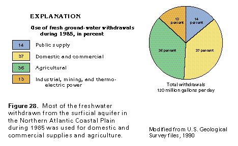
Total fresh ground-water withdrawals from the surficial aquifer were about 120 million gallons per day during 1985. The largest withdrawals of water were concentrated near Salisbury, Md., and Dover, Del. (fig. 27). Water from the aquifer was used principally for agricultural supplies and domestic and commercial purposes, but substantial quantities also were used for public supply and for industrial, mining, and thermoelectric power supplies (fig. 28).
CHESAPEAKE AQUIFER
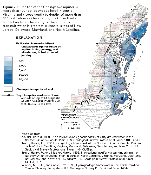
The Chesapeake aquifer is the uppermost regional aquifer of the Northern Atlantic Coastal Plain aquifer system. The aquifer consists of permeable beds in the Chesapeake Group of Oligocene to Pliocene age and their approximate stratigraphic equivalents. The top of the Chesapeake aquifer is mostly above sea level in New Jersey but is nearly 300 feet below sea level on the Outer Banks of North Carolina (fig. 29).
The Chesapeake aquifer in New Jersey includes the Cohansey Sand and most of the Kirkwood Formation, along with local terrace gravels. The local name of the Chesapeake aquifer is the Kirkwood-Cohansey aquifer system (fig. 21). In its thicker parts, confining units divide the Chesapeake aquifer into three local aquifers. The upper part of the aquifer is predominately fine to coarse sand that contains water mostly under unconfined conditions. The lower part is typically fine to medium sand that contains two thick clay beds near the coast. The maximum thickness of the Chesapeake aquifer in New Jersey is about 960 feet, but this includes about 450 feet of clay that forms local confining units in the lower part of the aquifer.
On the Delmarva Peninsula, the regional Chesapeake aquifer comprises six local sand aquifers, which consist of layers of medium to coarse, silty sand, and locally contain grav-el or shell fragments. The sands are separated by confining units of silty sand and clay. On the northwestern Delmarva Peninsula, the local aquifers are successively truncated and overlain from southwest to northeast by the surficial aquifer. Where the surficial and Chesapeake aquifers are in direct contact, they form a composite aquifer that contains water under unconfined, or water-table, conditions. The Chesapeake aquifer generally dips gently and thickens oceanward. Its total thickness exceeds 600 feet along the coast, but much of the thickening is due to clayey and silty sediments. The deeper and more southeasterly parts of the aquifer contain slightly saline to saline water. Only the upper part of the aquifer is important as a source of water in the Virginia part of the peninsula.
The Chesapeake aquifer in Maryland is not mapped west of Chesapeake Bay; sediments equivalent to the lower part of the aquifer extend west of the bay but consist mostly of clay and silt. The upper part of the Chesapeake aquifer west of the bay in Virginia is the local Yorktown-Eastover aquifer (fig. 21).
The Chesapeake aquifer in North Carolina is restricted to the northeastern part of the Coastal Plain. It consists of two local aquifers (fig. 21)-the upper (Yorktown) aquifer extends farther west than the lower (Pungo River) aquifer. The Yorktown aquifer consists of fine shelly sand, silty sand, and shell beds, whereas the Pungo River aquifer consists of fine to medium phosphatic sand. Where both local aquifers are present, the maximum thickness of the Chesapeake aquifer is about 1,000 feet; the average thickness is about 330 feet.
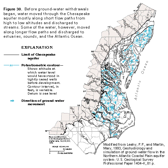
Much of the water in the upper part of the Chesapeake aquifer is under unconfined conditions. The aquifer is closely connected to streams, and before pumping began, most of the water that entered the aquifer as recharge from precipitation moved only a few miles or less along flow paths to discharge to the streams (fig. 30). Some of the water, however, moved along longer flow paths to discharge to estuaries or the ocean. Where the water table was close to the land surface, some ground water discharged to the atmosphere through evaporation and transpiration. Where hydraulic heads (water levels) in the Chesapeake aquifer were higher than those in the underlying Castle Hayne-Aquia aquifer, a small part of the water in the Chesapeake aquifer moved downward across a confining unit and into the lower aquifer. In some areas, mostly near the coast, the hydraulic head in the Castle Hayne-Aquia aquifer was greater than that in the Chesapeake aquifer, and water moved upward from the deeper aquifer into the Chesapeake aquifer.
The Chesapeake aquifer is considered to be a principal aquifer only where the transmissivity of the aquifer is greater than 500 feet squared per day (fig. 29). In these areas, wells completed in the aquifer commonly yield 50 gallons per minute or more. Elsewhere, the aquifer may yield water, but not in quantities sufficient for most uses; therefore, it is considered to be a minor aquifer. The transmissivity of the aquifer generally increases toward the coast and reaches a maximum near the southern border of Delaware and in a small area of coastal New Jersey. The coastward increase in transmissivity reflects an increase in the thickness of the aquifer in these areas.
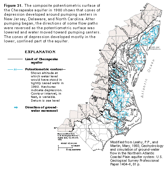
After withdrawals began, ground water continued to flow regionally in the same directions as before development, but some of the water that would have discharged to surface-water bodies or to the atmosphere under natural conditions was intercepted by wells. Flow paths shifted as water moved toward cones of depression that formed around pumping centers (fig. 31). By 1980, the potentiometric surface had been lowered over wide areas, which resulted in reduced evaporation and transpiration and increased recharge to the aquifer.
Withdrawals caused the potentiometric surfaces of the upper and lower parts of the aquifer to be different in parts of New Jersey, Delaware, and North Carolina. This is because thick confining beds within the aquifer impede vertical ground-water flow in these areas between the upper and lower parts of the aquifer. The lowering of the potentiometric surface induced saline water intrusion locally on the Cape May Peninsula and other coastal areas in New Jersey.
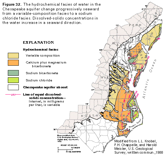
Water in the aquifers of the Northern Atlantic Coastal Plain aquifer system can be classified according to dominant dissolved cations and anions into the following hydrochemical facies typical of ground water in the Northern Atlantic Coastal Plain: variable composition, calcium plus magnesium bicarbonate, sodium bicarbonate, and sodium chloride. To demonstrate the facies classification used, a sodium bicarbonate water is one in which sodium ions account for more than 50 percent of the total cations in the water and bicarbonate ions account for more than 50 percent of the total anions. Waters classified as variable composition have no ions that exceed 50 percent.
The hydrochemical facies in water from the upper part of the Chesapeake aquifer in Virginia and North Carolina follow a general coastward, or downdip, sequence from a variable- composition facies in aquifer outcrop areas to a calcium plus magnesium bicarbonate facies, then to a sodium bicarbonate facies, and finally to a sodium chloride facies (fig. 32). This sequence is generally characteristic of waters in the Coastal Plain aquifers. Also, the concentration of dissolved solids in the ground water increases in a seaward direction. The distribution of hydrochemical facies with respect to areas where the Chesapeake aquifer crops out and with respect to the coast, and the seaward increase in dissolved-solids concentration, are largely the result of natural (prepumping) ground-water flow patterns. The same sequence of hydrochemical facies occurs with increasingdepth in the aquifers and is accompanied by an increase in the dissolved-solids concentration in the water.
Over most of its extent in New Jersey, the Chesapeake aquifer is exposed at the land surface and contains water of the variable-composition facies (fig. 32). In a narrow band parallel to the coast, the mixing of that water with saline water resulted in a sodium chloride facies. Dissolved-solids concentrations are generally less than 250 milligrams per liter, except along the coast. Sulfate is present locally in water from the aquifer in central New Jersey, probably as a result of the oxidation of sulfide minerals, such as pyrite, in the aquifer.
The hydrochemical facies pattern on the Delmarva Peninsula (fig. 32) is, for the most part, the result of ground water movement from aquifer recharge areas in the central part of the peninsula toward the Atlantic Ocean and the Delaware Bay on the east and northeast and toward the Chesapeake Bay on the west. The water changes northwestward and southeastward from a variable-composition facies to a calcium plus magnesium bicarbonate facies. Some of the change in facies also is due to northwestward truncation of local aquifers that contain water of differing character.
In the western parts of the coastal plain of North Carolina and Virginia, the hydrochemical facies of water in the Chesapeake aquifer cannot be identified conclusively because data are too sparse. Accordingly, the water is designated as "variable composition." Dissolved-solids concentrations in water from this area are generally less than 250 milligrams per liter. Seaward of this area in North Carolina, dissolved-solids concentrations increase to more than 2,000 milligrams per liter near the Albemarle Sound and the coast. Fossil shell material in the aquifer is a source of dissolved calcium and magnesium in the broad area mapped as calcium plus magnesium bicarbonate facies. Further eastward, clayey material in the aquifer acts as a natural softening agent, exchanging sodium ions for calcium to produce the sodium bicarbonate facies. The mixing of fresh ground water with saline water in the low-lying coastal area causes an increase in the dissolved-solids concentration of the water and a change to sodium chloride facies.
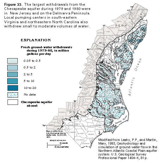
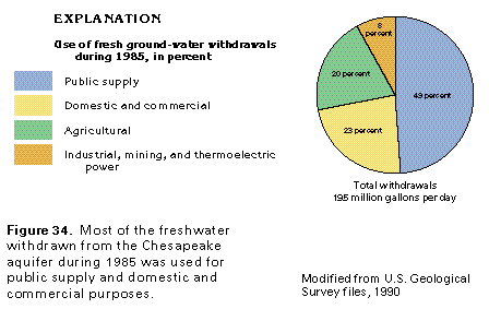
Total freshwater withdrawals from the Chesapeake aquifer during 1985 were estimated to be 195 million gallons per day. The distribution of major pumping centers, excluding irrigation, during 1979 and 1980 is shown in figure 33. The largest withdrawals of water were in New Jersey, although pumping centers on the Delmarva Peninsula also withdrew large volumes of water. Withdrawal centers in eastern North Carolina and southeastern Virginia pumped only small to moderate volumes of water.
About one-half of the freshwater withdrawn from the Chesapeake aquifer during 1985 (about 95 million gallons per day) was used for public supply (fig. 34). About 45 million gallons per day was withdrawn for domestic and commercial use. Agricultural withdrawals accounted for about 39 million gallons per day during 1985, and only about 16 million gallons per day was withdrawn for industrial, mining, and thermoelectric power uses.
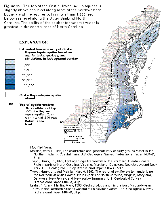
The Castle Hayne-Aquia aquifer extends from New Jersey southward to southeastern North Carolina (fig. 35). The aquifer consists mostly of permeable strata of Eocene and Paleocene age but locally includes rocks of Oligocene age. The top of the aquifer is about at sea level in most places near its northwestern limit and slopes seaward to depths of more than 750 feet below sea level in New Jersey and more than 1,250 feet below sea level on the Outer Banks of North Carolina. The aquifer is absent in the southwestern one-third of the Delmarva Peninsula, where its permeable beds grade eastward into clay. A clayey confining unit overlies the aquifer almost everywhere and is thickest on the western shore of the Chesapeake Bay in Maryland where it consists of as much as 250 feet of diatomaceous clay.
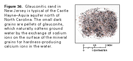
In New Jersey, the regional Castle Hayne-Aquia aquifer consists of the local Piney Point and Vincentown aquifers (fig. 21), which are thin sand aquifers within a thick confining unit of silt and clay. The name "Piney Point aquifer" is applied in this chapter to permeable, fine to coarse, glauconitic sand (fig. 36) that was formerly correlated in New Jersey as the Eocene Piney Point Formation but is now (1996) considered to be a separate, younger, unnamed sand that is hydraulically connected to permeable sands of the Piney Point Formation in Maryland. The underlying Vincentown aquifer consists of sparsely glauconitic quartz sand and fossiliferous, calcareous, quartz sand. In Burlington, Ocean, and Monmouth Counties, N.J., moderately permeable sand of the Vincentown aquifer grades southeastward into silt and clay within a few miles of the outcrop area of the aquifer. In this area, the Vincentown aquifer is laterally separated from the Piney Point aquifer by less permeable sediments (fig. 35). The maximum thickness of the Castle Hayne-Aquia aquifer in New Jersey is 220 feet, and the average thickness is about 90 feet.
The regional Castle Hayne-Aquia aquifer in Delaware, Maryland, and Virginia is subdivided into two local aquifers (fig. 21). The upper aquifer, which is called the Piney Point-Nanjemoy aquifer in Delaware and Maryland and the Chickahominy-Piney Point aquifer in Virginia, consists of medium to coarse glauconitic sand mainly in the Piney Point and the Nanjemoy Formations. The lower aquifer, which is called the Aquia-Rancocas aquifer in Delaware and Maryland and the Aquia aquifer in Virginia, consists of glauconitic sand of the Aquia Formation or the Rancocas Group. The upper aquifer consists predominately of Eocene sands, but contains some sands of Oligocene age; the lower aquifer consists of Paleocene sands. The aquifers are separated by a silt and clay confining unit that ranges in thickness from a few feet in southern Virginia to as much as 210 feet in northeastern Maryland. The maximum thickness of the Castle Hayne-Aquia aquifer in Delaware, Maryland, and Virginia exceeds 460 feet, and the average thickness is about 140 feet.
In North Carolina, the regional Castle Hayne-Aquia aquifer consists of two local aquifers-the Castle Hayne aquifer (a major aquifer) and the underlying, less important Beaufort aquifer. The Castle Hayne aquifer is limestone, sandy marl, and fine to coarse limey sand. It includes most of the Eocene Castle Hayne Formation and the lithologically similar Oligocene River Bend Formation. This aquifer is restricted to the eastern one-half of the North Carolina Coastal Plain, and its average thickness is about 185 feet. The Beaufort aquifer, which is fine to medium glauconitic sand, contains thin beds of shell and limestone. It extends farther north and south than the Castle Hayne aquifer, but its thickness is generally less than 50 feet. The two aquifers are separated by a confining unit of silt, clay, and sandy clay that is generally less than 50 feet thick but is as much as 180 feet thick along the coast.
The Castle Hayne-Aquia aquifer is considered to be a major aquifer except for areas where the transmissivity of the aquifer is less than 1,000 feet squared per day (fig. 35). In these areas of low transmissivity, which are mostly in Virginia, Maryland, and Delaware, the aquifer is thin. It thins westward because it pinches out as a result of erosion, but the eastward thinning is the result of a change in facies from sand to clay. The transmissivity of the aquifer is highest in southeastern North Carolina, where it is mostly a thick section of highly permeable limestone.
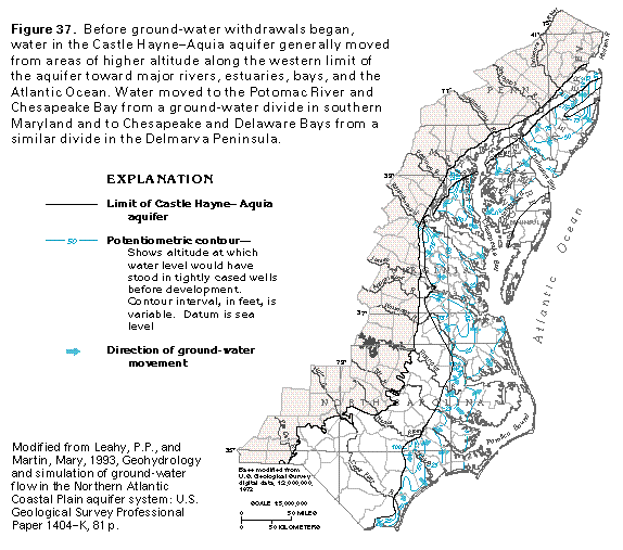
Before ground-water withdrawals began, water moved from recharge areas of higher altitude along the western limit of the aquifer toward rivers, estuaries, bays, and the Atlantic Ocean (fig. 37). In New Jersey, flow was generally toward the ocean, the Delaware River, and the Delaware Bay. Flow in the western shore of Maryland was from the northwestern limit of the aquifer toward both the Potomac River and Chesapeake Bay. A ground-water divide on the Delmarva Peninsula separated flow to Chesapeake Bay from flow to Delaware Bay. In Virginia, flow was generally along shorter flow paths from recharge areas toward the major rivers. The regional movement of water in North Carolina was eastward, along long flow paths from recharge areas that are less than 50 feet above sea level (except for local areas in Bertie, Lenoir, and Duplin Counties) toward sounds and the ocean.
In addition to lateral flow, water also entered and left the Castle Hayne-Aquia aquifer from overlying and underlying aquifers by vertical leakage through confining units. Because the Castle Hayne-Aquia aquifer is buried throughout most of its extent, it does not receive recharge directly from precipitation and does not discharge by evapotranspiration. Nevertheless, where the aquifer is near the surface, most of the ground water moved through local flow systems in which water entered the aquifer by downward leakage through a confining unit and discharged a short distance away by upward leakage to another aquifer or to a stream.
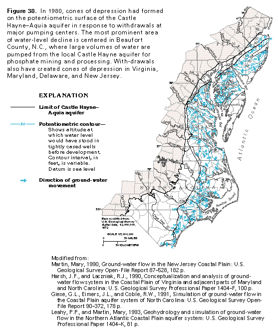
Ground-water withdrawals lowered the hydraulic head in the aquifer and formed cones of depression in its potentiometric surface (fig. 38). The direction of ground-water flow was changed in and around the pumping centers, and was reversed from the prepumping flow direction in some places (compare figs. 37 and 38). Heads have declined in small areas in New Jersey and the western shores of Maryland and Virginia as a result of withdrawals at pumping centers. The most prominent areas of decline in hydraulic head are in the central Del-marva Peninsula, where water is withdrawn from the local Piney Point and Aquia-Rancocas aquifers for public supply and in the southern part of the North Carolina Coastal Plain, where large volumes of water have been withdrawn from the local, highly productive Castle Hayne aquifer for mining uses and public supply.
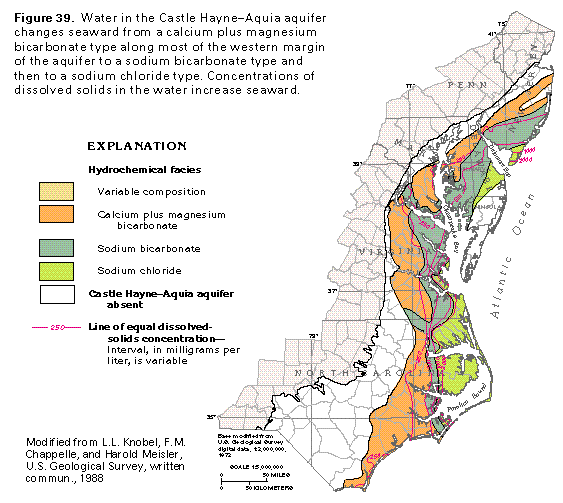
Water in the Castle Hayne-Aquia aquifer changes in a seaward direction from a calcium plus magnesium bicarbonate hydrochemical facies along most of the western margin to a sodium bicarbonate facies in the middle parts and then to a sodium chloride facies near the coast (fig. 39). Dissolved-solids concentrations in the water increase seaward from the landward margins of the aquifer. These distributions are mostly the result of natural ground-water flow patterns. Whole or broken fossil shell material characterizes the aquifer from New Jersey southward through Virginia; in North Carolina, the aquifer is mostly limestone. Chemical reactions between ground water and the shell material or limestone minerals within the aquifer near its western limit are predominately dissolution and precipitation of calcareous material, which results in a calcium plus magnesium bicarbonate hydrochemical facies. This facies is especially widespread in North Carolina because of the abundant calcium and magnesium carbonate in the Castle Hayne aquifer.
The band of sodium bicarbonate facies in the aquifer is broader from New Jersey through Virginia than in North Caroina. In this band, ion-exchange reactions predominate. Glauconite is abundant in the aquifer north of North Carolina and is the principal agent in the exchange of sodium for calcium ions, a process that produces a sodium bicarbonate type water. The sodium chloride facies is in much of the low-lying coastal area, particularly in North Carolina, where the mixing of freshwater with saline water is the most important chemical process.
A small area of variable-composition facies is situated along the outcrop of the aquifer in Anne Arundel County, Md. Because the hydraulic gradient is steep, the ground water moves rapidly and is in contact with aquifer minerals for only a brief time. Accordingly, the water does not assume a distinctive chemical type.
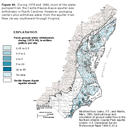
The distribution of major pumping centers that withdrew water from the Castle Hayne-Aquia aquifer during 1979 and 1980 for all purposes except irrigation is shown in figure 40. The largest withdrawals were in North Carolina. During 1980, 67 million gallons per day were pumped from the aquifer in Beaufort County, N.C., to lower the pressure in the aquifer under open-pit phosphate mines and to wash and process the phosphate ore. Large volumes of water also were withdrawn in North Carolina for public supplies for the cities of New Bern, Jacksonville, and Wilmington. Most of the water withdrawn from the aquifer in pumping centers in Virginia and northward was used for public supplies and domestic and commercial uses.
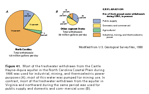
Total fresh ground-water withdrawals from the Castle Hayne-Aquia aquifer were estimated to be 164 million gallons per day during 1985. The amount of water withdrawn was much greater in North Carolina than in the other Segment 11 States combined, and the use of the water also was much different (fig. 41).
About 76 percent of the total withdrawals, or about 125 million gallons per day, were in North Carolina (fig. 41A). Most of the water withdrawn in North Carolina was used for mining, industrial, and thermoelectric power purposes, with about 88 million gallons per day being pumped for this use; most of this water was used by the mining industry. Withdrawals in North Carolina for domestic and commercial, public supply, and agricultural uses were about 21, 13, and 4 million gallons per day, respectively.
About 24 percent of the total withdrawals, or about 39 million gallons per day, were in Virginia, Maryland, Delaware, and New Jersey (fig. 41B). About 46 percent of the water withdrawn, or about 18 million gallons per day, was pumped for domestic and commercial uses. Withdrawals for public supply were about 14 million gallons per day. About 5 million gallons per day was withdrawn for mining, industrial, and thermoelectric power use, and about 2 million gallons per day was withdrawn for agricultural purposes.
SEVERN-MAGOTHY AQUIFER
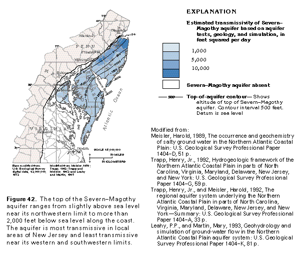
The Severn-Magothy aquifer underlies most of the New Jersey Coastal Plain and the Delmarva Peninsula and is on the Maryland part of the western shore of Chesapeake Bay (fig. 42). The aquifer consists of permeable sand beds of Late Cretaceous age. The top of the aquifer is slightly above sea level along its northwestern limit and slopes southeastward to depths of more than 2,000 feet below sea level. Except where it crops out near its western limit, the aquifer is overlain by a confining unit of silt and clay.
The Severn-Magothy aquifer in New Jersey consists of three local aquifers (fig. 21), which are named for the geologic units that compose the aquifers. From top to bottom, these are the Wenonah-Mount Laurel aquifer, the Englishtown aquifer, and the upper (Magothy) part of the Potomac-Raritan-Magothy aquifer. The Wenonah-Mount Laurel aquifer is predominately fine to medium glauconitic sand; the Englishtown aquifer is fine to medium sand and has some beds of clay and silt; and the Magothy aquifer typically consists of well-stratified to crossbedded, fine to medium sand. Each of the local aquifers is separated from the underlying aquifer by a confining unit of clay and silt. The confining unit between the Wenonah-Mount Laurel and the Englishtown aquifers is generally from 25 to 70 feet thick; the one that underlies the Englishtown aquifer is generally from 100 to 400 feet thick and effectively isolates the deep Magothy aquifer from the overlying aquifers. The maximum thickness of the Severn-Magothy aquifer in New Jersey exceeds 720 feet, and the average thickness is about 340 feet.
In Delaware, Maryland, and the Eastern Shore of Virginia, the Severn-Magothy aquifer consists of sand beds in the Severn Formation, the Mount Laurel Sand, the Matawan Formation (or Group), and the Magothy Formation. The sands are generally similar in lithology to their equivalents in New Jersey, except that the sands of the Severn, the Mount Laurel, and the Matawan are thinner, finer grained, and contain more clay than those in New Jersey; the Magothy Formation, therefore, contains the principal water-yielding sands. Confining units of finer grained, and contain more clay than those in New Jersey; the Magothy Formation, therefore, contains the principal water-yielding sands. Confining units of clay and silt separate the local Severn and Matawan aquifers and the local Matawan and Magothy aquifers. Each of the confining units is generally from 50 to 75 feet thick in Delaware but is thinner in Maryland and Virginia. The maximum thickness of the Severn-Magothy aquifer in Delaware, Maryland, and Virginia is about 385 feet; the average thickness is about 185 feet.
In a few local areas, the transmissivity of the Severn-Magothy aquifer is less than 1,000 feet squared per day (fig. 42). The aquifer is thin in these areas and generally yields less than 50 gallons per minute to wells. Throughout most of its area, the aquifer has a transmissivity of less than 5,000 feet squared per day, but transmissivity values exceed 10,000 feet squared per day in two local areas in New Jersey.
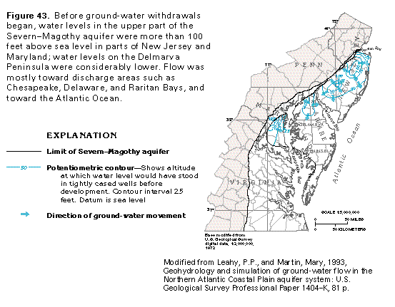
Before development of the aquifer began, water levels in the upper part of the regional Severn-Magothy aquifer were more than 100 feet above sea level in places along a ground-water divide in the central part of the New Jersey Coastal Plain and in aquifer outcrop areas in Anne Arundel and Prince Georges Counties, Md. (fig. 43). Water levels were less than 50 feet above sea level on the Delmarva Peninsula. Regional ground-water movement was toward the Atlantic Ocean and Chesapeake, Delaware, and Raritan Bays. Before pumping began, the configuration of the potentiometric surface of the local Magothy aquifer (the lower part of the regional Severn-Magothy aquifer) was generally similar to that shown in figure 43. However, because recharge to the local Magothy aquifer in New Jersey was impeded by the substantial thickness of the overlying clay and silt confining unit, water levels in the local Magothy aquifer were as much as 50 feet lower than those in the upper part of the regional Severn-Magothy aquifer. For the upper and lower parts of the Severn-Magothy aquifer, regional flow was along intermediate to long flow paths, and the water moved from outcrop recharge areas toward discharge areas at lowlands, major bays, and the Atlantic Ocean. In addition to the lateral flow, water also moved vertically into and out of the Severn-Magothy aquifer from overlying and underlying aquifers by leakage across confining units. Except in aquifer outcrop areas along its northwest ern boundary, the Severn-Magothy aquifer is covered by a confining unit and thus does not receive direct recharge by precipitation, nor does it discharge water by evapotranspiration.
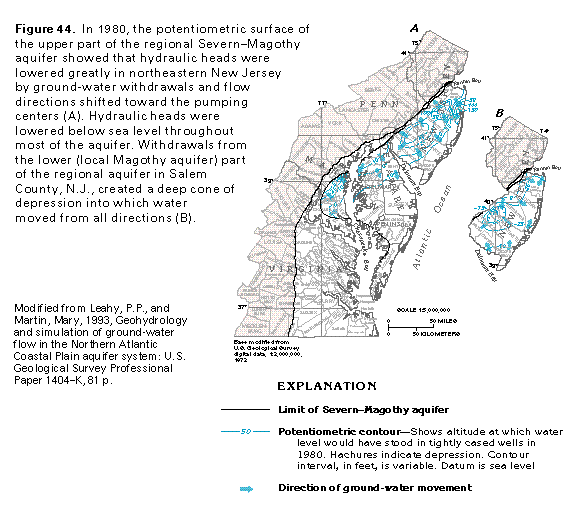
Ground-water withdrawals caused a general decline in the potentiometric surface throughout the aquifer, created cones of depression in the potentiometric surface (fig. 44), and changed the directions of ground-water movement near pumping centers. In the upper part of the regional Severn-Magothy aquifer, withdrawals lowered the potentiometric surface to more than 150 feet below sea level in northeastern New Jersey. Hydraulic heads were lowered below sea level over much of the extent of the aquifer in eastern New Jersey, most of the Delmarva Peninsula, and part of the western shore of Maryland as a result of pumping. The lowered heads resulted in intrusion of saline water into the aquifer along Raritan Bay. The lowered hydraulic head in the Severn-Magothy aquifer in central Delaware is attributed in part to withdrawals from the overlying Castle Hayne-Aquia aquifer (local Piney Point aquifer), which caused water to move upward into the shallower aquifer through a leaky confining unit.
By 1980, water-level declines in response to withdrawals in southwestern New Jersey were larger in the lower part (local Magothy aquifer) of the regional Severn-Magothy aquifer than in the upper part. Much more water was pumped from the lower part of the regional aquifer than from the upper part, and the thick confining unit that overlies the lower part of the aquifer retarded recharge from above. The potentiometric surface was more than 75 feet below sea level in 1980 (fig. 44) in an area of central Camden County, New Jersey, where the predevelopment potentiometric surface of the upper part of the aquifer was more than 100 feet above sea level (fig. 43). Withdrawals loweredthe potentiometric surface below sea level throughout most of the lower part of the regional aquifer in New Jersey and resulted in saline water encroachment into the aquifer in Salem County, N.J., and along Raritan Bay.
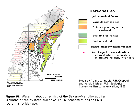
Hydrochemical facies in the upper part of the Severn-Magothy aquifer show the same coastward sequence that is typical of water in aquifers of the northern Atlantic Coastal Plain-variable composition at the western margin, grading eastward to calcium plus magnesium bicarbon ate, grading, in turn, to sodium bicarbonate, and, finally, to sodium chloride in downdip parts of the aquifer (fig. 45). The facies generally appear vertically in the same sequence downward in the aquifer. Predevelopment ground-water flow patterns largely determine the distribution of hydrochemical facies and the seaward increase in dissolved-solids concentrations in the water. Local intrusion of saline water as a result of withdrawals is not shown at this map scale.
The upper part of the regional Severn-Magothy aquifer contains glauconite in most places. Glauconite is active in base-exchange reactions-the mineral exchanges sodium ions for calcium ions, which naturally softens the water. This proc-ess is reflected by the broad band of sodium bicarbonate facies across the Delmarva Peninsula and New Jersey (fig. 45). Because the lower part of the Severn-Magothy aquifer on the western shore of Maryland does not contain glauconite, the base exchange process is less active, and the band of sodium bicarbonate facies is narrower. The dissolved-solids concentration in water from the upper part of the Severn-Magothy aquifer increases downdip to more than 2,000 milligrams per liter in southern New Jersey and the eastern Delmarva Peninsula (fig. 45). Mixing of freshwater with saline water in low-lying coastal areas is responsible for the large increase in dissolved solids and the change to a sodium chloride facies.
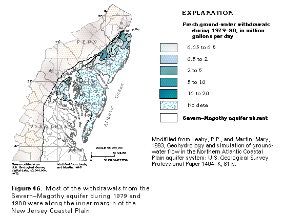
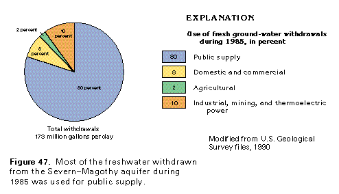
Major pumping centers that withdrew water from the Severn-Magothy aquifer during 1979 and 1980 were located mostly near its western limit (fig. 46). The greatest rate of withdrawal, by far, was in New Jersey; however, numerous pumping centers also withdrew water in Maryland. Total fresh ground-water withdrawals from the aquifer were estimated to be 173 million gallons per day during 1985 (fig. 47). Withdrawals in New Jersey were 151 million gallons per day during this period. Of the water withdrawn, 80 percent, or about 138 million gallons per day, was used for public supply. About 17 million gallons per day was withdrawn for industrial, mining, and thermoelectric power purposes. Withdrawals for domestic and commercial uses were about 14 million gallons per day, and only about 4 million gallons per day was withdrawn for agricultural use.
PEEDEE-UPPER CAPE FEAR AQUIFER
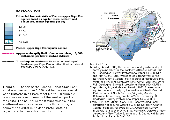
The regional Peedee-upper Cape Fear aquifer underlies most of the North Carolina Coastal Plain and extends into a small part of southeastern Virginia (fig. 48). The aquifer consists of permeable sands of the Peedee Formation, the Black Creek Formation, and the upper part of the Cape Fear Formation, all of Late Cretaceous age, and their stratigraphic equivalents in Virginia. The Peedee-upper Cape Fear aquifer is the lateral equivalent of the Severn-Magothy aquifer, but the two aquifers are not known to be connected. A clayey confining unit overlies the Peedee-upper Cape Fear aquifer in most places. The top of the aquifer is above sea level over much of the western part of the North Carolina Coastal Plain and slopes eastward to a depth of more than 3,000 feet below sea level at Cape Hatteras. The entire aquifer contains saline water in a large area in eastern North Carolina, approximately where the top of the aquifer is 1,000 feet below sea level or deeper. No fresh ground water circulates in the aquifer east of the line that represents water with 10,000 milligrams per liter chloride concentration (fig. 48).
The regional Peedee-upper Cape Fear aquifer in North Carolina consists of the local Peedee, Black Creek, and upper Cape Fear aquifers (fig. 21), which are separated by confining units of clay and silt that generally range from 20 to 70 feet in thickness. The Peedee aquifer consists of fine tomedium glauconitic sand of the Peedee Formation, and contains shell material and calcareous sandstone beds. The Black Creek aquifer consists of very fine to fine lignitic, glauconitic, and shelly sand interbedded with clay of the Black Creek Formation, and fine to medium sand, with lenses of coarse sand and clay of the underlying Middendorf Formation. The Black Creek aquifer is the thickest and most productive of the three local aquifers. The upper Cape Fear aquifer consists mostlyof alternating beds of fine to medium sand and clay of the upper part of the Cape Fear Formation. The maximum thickness of the regional Peedee-upper Cape Fear aquifer is about 1,200 feet; the average is about 570 feet. The greater thicknesses are along the coast, but the aquifer contains saline water there.
In Virginia, sand beds equivalent to the upper part of the Cape Fear Formation have been assigned to the local upper Potomac aquifer (fig. 21). Beds equivalent to the local Peedee and Black Creek aquifers are mostly absent in Virginia. The average thickness of the regional Peedee-upper Cape Fear aquifer in Virginia is about 95 feet.
Where the transmissivity of the Peedee-upper Cape Fear aquifer is less than 1,000 feet squared per day (fig. 48), the aquifer is considered to be a minor aquifer. Wells completed in the aquifer in this low-transmissivity area yield less than 50 gallons per minute. By contrast, in some areas, the transmissivity of the aquifer is greater than 10,000 feet squared per day; in such areas, yields of 1,000 gallons per minute or more are obtained from properly constructed wells.
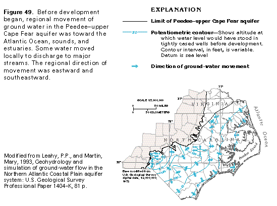
The potentiometric surface of the Peedee-upper Cape Fear aquifer was more than 400 feet above sea level in the southwestern corner of the North Carolina Coastal Plain before ground-water withdrawals began (fig. 49). The high areas on the potentiometric surface coincide with the high altitude of the land surface. By contrast, the potentiometric surface in Virginia was less than 50 feet above sea level throughout the aquifer. Ground water moved regionally from areas of high hydraulic head, generally along the western limit of the aquifer, toward areas of low head along the coast and beneath sounds and estuaries. The direction of regional movement was eastward and southeastward along long flow paths. Locally, some water moved from recharge areas along short to intermediate flow paths and discharged to streams. In addition to the lateral flow indicated by the arrows in figure 49, water also leaked through confining units vertically into and out of the Peedee-upper Cape Fear aquifer from overlying or underlying aquifers that had hydraulic heads greater than those in the aquifer. Where the heads in the Peedee-upper Cape Fear aquifer were higher than those in adjacent aquifers, the leakage was reversed. Direct recharge by precipitation or discharge by evapotranspiration took place where the aquifer is exposed at the land surface.
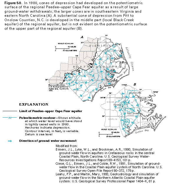
The potentiometric surface of the aquifer has been lowered in and around pumping centers where large volumes of water are withdrawn. The direction of ground-water movement has been changed or, in places, reversed so that flow is toward the pumping centers. Cones of depression (fig. 50) have formed in the potentiometric surface of the upper part of the aquifer around the areas where withdrawals are greatest. One large area of decline in southeastern Virginia is the result of pumping for public supply. Another area of decline in Beaufort County, N.C., is the result of large withdrawals from the Castle Hayne-Aquia aquifer. The withdrawals from this shallower aquifer, which are primarily for mining purposes, have induced upward leakage of water from the Peedee-upper Cape Fear aquifer through the confining unit that overlies it. The hydraulic head in the middle part of the Peedee-upper Cape Fear aquifer (the local Black Creek aquifer) has declined in the area of Kinston and Greenville, N.C. (fig. 50), but the decline is not evident in the potentiometric surface of the upper part of the aquifer. The decline is the result of withdrawals for public supply. Water levels in the local Black Creek aquifer have been drawn down more than those in the overlying local Peedee aquifer because most of the pumping wells are completed in the Black Creek aquifer and the confining unit that overlies the Black Creek aquifer is thicker and retards flow more effectively than the one above the Peedee aquifer.
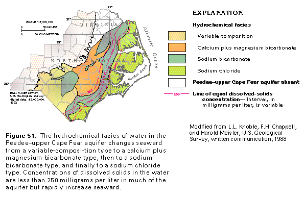
The water in the upper part of the Peedee-upper Cape Fear aquifer is of variable composition over a large area in the western part of the North Carolina Coastal Plain (fig. 51). The processes of dissolution of shell material and precipitation of carbonate minerals predominate in the area where the water is a calcium plus magnesium bicarbonate type. In the southwestern part of the aquifer, the sodium bicarbonate facies is adjacent to the variable-composition facies; because the aquifer contains glauconitic sand and little or no shell material, the calcium plus magnesium bicarbonate facies is absent. A band of sodium bicarbonate facies is west of the widespread area of sodium chloride facies that is the result of mixing of saltwater and freshwater. The coastward progression of hydro-chemical facies is typical of that in other aquifers of the Northern Atlantic Coastal Plain and is mostly the result of predevelopment ground-water flow patterns.
In the areas of variable-composition and calcium plus magnesium bicarbonate facies, dissolved-solids concentrations in water from the upper part of the aquifer are generally less than 250 milligrams per liter. Dissolved-solids concentrations increase coastward to more than 2,000 milligrams per liter, mostly in the area of sodium chloride facies. In the easternmost part of the North Carolina Coastal Plain, water in the aquifer contains more than 10,000 milligrams per liter chloride (fig. 48) and probably as much as 20,000 milligrams per liter dissolved solids in some places.
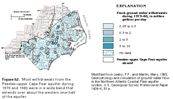
Numerous pumping centers withdrew water from the Peedee-upper Cape Fear aquifer during 1979 and 1980 (fig. 52). Use of the aquifer was widespread during this period, especially toward its western margin. The largest withdrawals, however, were in the central parts of the aquifer, where several cities withdrew water for public supplies.
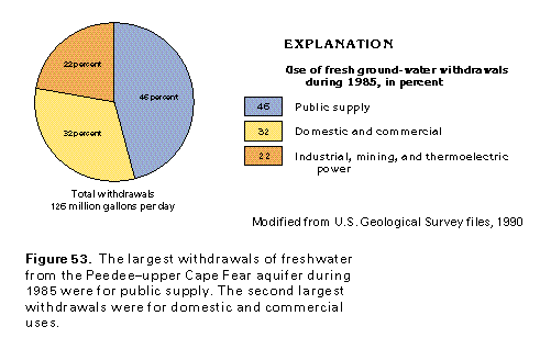
Total fresh ground-water withdrawals from the Peedee-upper Cape Fear aquifer were estimated to be 126 million gallons per day during 1985 (fig. 53). Most of the water (about 58 million gallons per day) was withdrawn for public supply. Domestic and commercial withdrawals were about 40 million gallons per day, and about 28 million gallons per day were withdrawn for industrial, mining, and thermoelectric power uses.
POTOMAC AQUIFER
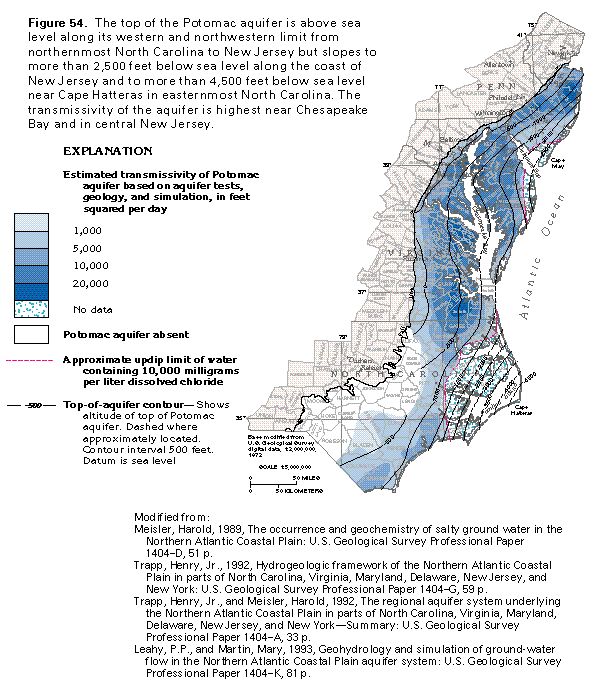
The regional Potomac aquifer underlies the entire Northern Atlantic Coastal Plain except for small areas near the Fall Line in Virginia, Maryland, and Delaware, and a multicounty area in the western part of the North Carolina Coastal Plain (fig. 54). The aquifer is the lowermost, and most widespread, aquifer of the Northern Atlantic Coastal Plain aquifer system. The Potomac aquifer consists mostly of permeable sands in the Potomac Formation (or Group) and their stratigraphic equivalents but includes younger, hydraulically connected, permeable sediments. The top of the aquifer is above sea level only in a narrow band near its western limit from New Jersey southward to Northampton County, N.C. The aquifer is more than 2,500 feet below sea level in southern New Jersey and on the easternmost part of the Delmarva Peninsula and more than 4,500 feet below sea level in easternmost North Carolina. A confining unit of clay and sandy clay overlies the aquifer in most places and is particularly effective in retarding vertical flow near Cape May, N.J., where its thickness is greater than 700 feet.
The regional Potomac aquifer in New Jersey includes the middle and lower aquifers of the Potomac-Raritan-Magothy aquifer system (fig. 21). The middle aquifer consists mostly of permeable beds of the Raritan Formation and the undifferentiated Potomac Formation and is mostly lenticular sand bodies interbedded with clay and silt, predominately of fluvial origin. The lower aquifer of the Potomac-Raritan-Magothy aquifer system is similar in lithology to the middle aquifer but contains more sand. The two local aquifers are separated by an indistinctly defined confining unit of clay and sandy clay that is generally from 50 to 150 feet thick where the regional Potomac aquifer contains freshwater but is more than 1,000 feet thick at the southeastern tip of New Jersey, where the aquifer contains saline water. The maximum thickness of the regional Potomac aquifer in New Jersey is about 3,400 feet, and the average thickness is about 630 feet. These thicknesses, as well as the those described below for the other States, include clay between the deepest permeable sand and bedrock and sands that contain saline water and effectively are not part of the aquifer.
The regional Potomac aquifer in Delaware and Maryland consists of the local Patapsco aquifer and the underlying local Patuxent aquifer, both named for sand and gravel formations of the Potomac Group that crop out in the northern part of the Maryland Coastal Plain. The Patapsco aquifer typically is lenses of fine to medium sand that range in length and width from a few feet to several miles, contain some gravel, and are separated by clay beds. The Patuxent aquifer typically is medium to coarse gravelly sand, and also is lenticular. A clayey confining unit that separates the two local aquifers generally is from 50 to 300 feet thick in northern Delaware and the western shore of Maryland, where the regional Potomac aquifer contains freshwater, but is more than 900 feet thick at the mouth of Delaware Bay where the water in the aquifer is saline. The regional Potomac aquifer thickens and contains more clay to the southeast. The sediments that make up the Poto-mac aquifer are predominately of fluvial and deltaic origin. The maximum thickness of the aquifer in Delaware and Maryland is about 5,000 feet, and the average thickness is about 1,600 feet.
The regional Potomac aquifer in Virginia consists of the local middle and lower Potomac aquifers, which are approximately equivalent to the Patapsco and the Patuxent aquifers, respectively, of Maryland and Delaware, and consist of fine to coarse gravelly sand. The local middle and lower Potomac aquifers are separated by a clayey confining unit that generally is from 15 to 100 feet thick in the western part of the Coastal Plain where the regional Potomac aquifer contains freshwater and as much as 175 feet thick on the Delmarva Peninsula where the aquifer contains saline water. The maximum thickness of the regional Potomac aquifer in Virginia is about 4,600 feet, and the average thickness is about 800 feet.
The regional Potomac aquifer in North Carolina consists of two local aquifers-the lower Cape Fear aquifer and the Lower Cretaceous aquifer (fig. 21). The lower Cape Fear aquifer consists of fine to medium sand (interbedded with clay) of the lower part of the Cape Fear Formation and other hydraulically connected permeable sediments. The Lower Cretaceous aquifer is predominately fine to medium sand with a few beds of coarse sand and limestone, all of which are in Lower Cretaceous strata. These Lower Cretaceous beds are not exposed at the surface, are known only through data from a few wells, and have no formal stratigraphic names. The Lower Cretaceous aquifer has been defined only in the northern part of the North Carolina Coastal Plain; farther south along the coast, equivalent beds contain saline water. The maximum thickness of the regional Potomac aquifer in North Carolina is about 4,900 feet, and the average thickness is about 500 feet.
The Potomac aquifer is considered to be a major aquifer except for local areas in North Carolina where the transmissivity of the aquifer is less than 1,000 feet squared per day (fig. 54); in these low-transmissivity areas, the aquifer is thin. The aquifer thins westward because it has been partly eroded away, but the eastward thinning is due to a facies change from sand to clay. The coastward increase in clay and decrease in sand also is shown by the distribution of transmissivity in Virginia and northward. Transmissivity values increase eastward from the western limits of the aquifer to its central parts, mostly because the thickness of the aquifer steadily increases seaward. East of the high-transmissivity areas, the transmissivity of the aquifer decreases due to the eastward change in facies from sand to clay, even though the total thickness of the aquifer continues to increase.
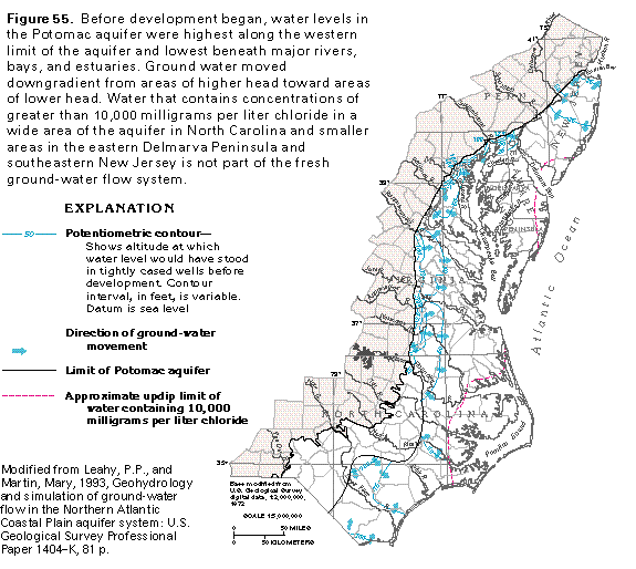
The potentiometric surface of the regional Potomac aquifer was highest along its western limit and in a small area along the South Carolina-North Carolina State line before withdrawals began (fig. 55). The potentiometric surface was higher at or near the higher land altitudes and lowest where ground water discharged to major rivers, bays, and the Atlantic Ocean. Regional ground-water movement was eastward and southeastward except in North Carolina where regional movement was toward the central part of the Coastal Plain. Water that contains concentrations of 10,000 milligrams per liter or more chloride marks the limit of the fresh ground-water flow system. Flow in North Carolina was effectively diverted by this saltwater body so that the ground water discharged to major streams in the central Coastal Plain. Only lateral flow is shown by the arrows in figure 55, but water also leaked vertically into and out of the Potomac aquifer from the overlying aquifers. The Potomac aquifer mostly is covered by confining units and thus receives little direct recharge by precipitation or discharges little water by evapotranspiration.
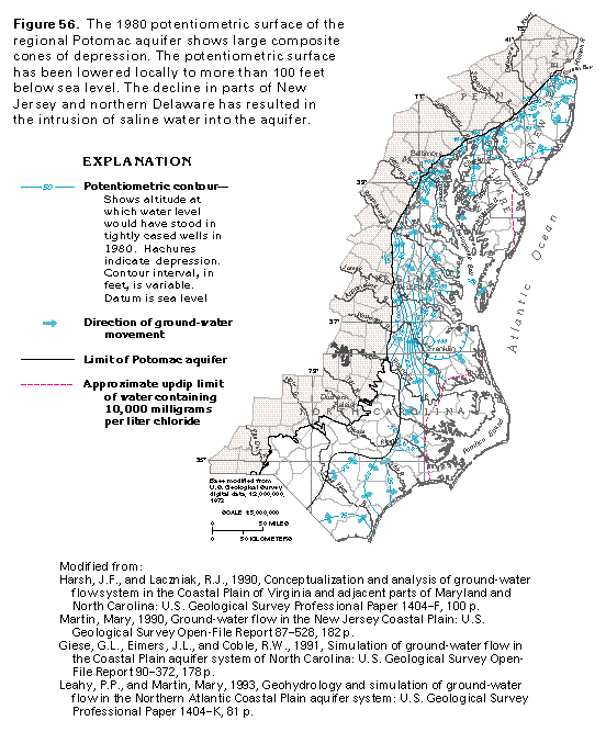
After withdrawals from the regional Potomac aquifer began, much of the flow was diverted toward major pumping centers, and large cones of depression formed in the potentiometric surface (fig. 56). A composite cone has developed over most of the New Jersey Coastal Plain and part of northern Delaware. By 1980, hydraulic heads in this area had declined to more than 25 feet below sea level throughout the area of the cone and to more than 100 feet below sea level in a small area in Delaware. Saline water has encroached into the aquifer along Raritan Bay, along the lower Delaware River in New Jersey, and around the harbor at Baltimore, Md., because of the lowered hydraulic heads. A prominent composite cone more than 100 feet below sea level around Franklin, Va., and more than 50 feet below sea level in much of southern Virginia also extends into North Carolina. The cone reflects large withdrawals for industrial use, primarily to supply paper mills at Franklin and West Point, Va.
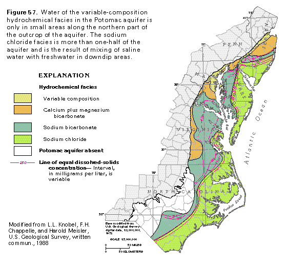
Hydrochemical facies of water in the regional Potomac aquifer show the same general seaward progression from variable composition to sodium chloride facies as other Coastal Plain aquifers (fig. 57). The variable-composition facies, however, is only in small areas where the aquifer crops out in New Jersey and Maryland. Along much of the western boundary of the aquifer in Delaware, southwestern Maryland, and northern Virginia, the calcium plus magnesium bicarbonate facies prevails. This facies might be the result of recharge by downward leakage from overlying aquifers that contain carbonate minerals in the form of shell material. The predominance of sodium bicarbonate water in large areas of the aquifer results partly from ion-exchange reactions that take place in water that percolates downward through overlying aquifers and confining units to the regional Potomac aquifer and partly from ion-exchange reactions within the Potomac aquifer. Freshwater mixes with saline water in near-coastal areas of the aquifer and produces the sodium chloride facies.
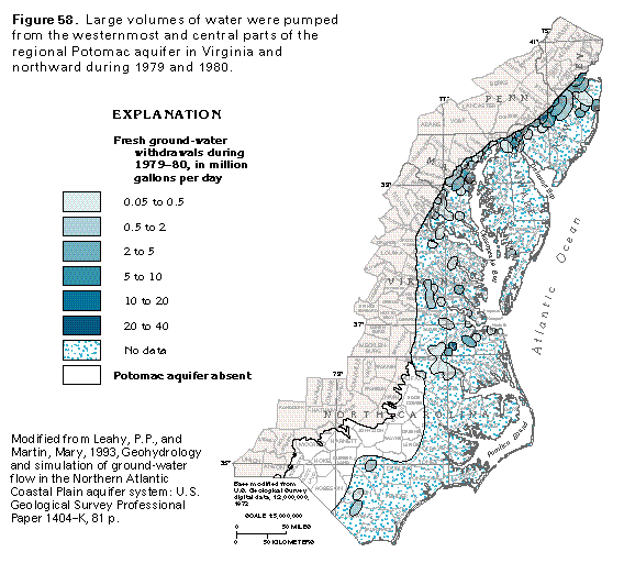
Most of the major pumping centers that withdrew water from the Potomac aquifer during 1979 and 1980 were near its western margin (fig. 58). However, large withdrawals were made in Virginia in the central parts of the Coastal Plain. The pumping centers in Virginia mostly supplied water for industrial, mostly paper-manufacturing, uses; those farther northward mostly provided public supplies.
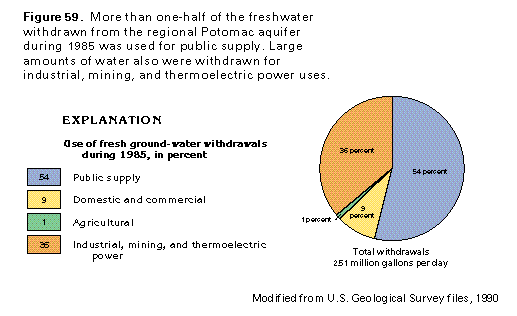
Total fresh ground-water withdrawals from the Potomac aquifer were estimated to be 251 million gallons per day during 1985 (fig. 59). Of this amount, about 54 percent, or about 135 million gallons per day, was withdrawn for public supply. Withdrawals for industrial, mining, and thermoelectric power uses were the second largest withdrawal category; about 90 million gallons per day was pumped for those uses. Domestic and commercial withdrawals were about 23 million gallons per day, and only about 3 million gallons per day was pumped for agricultural use.