INTRODUCTION
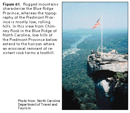
Most of the Piedmont and the Blue Ridge Physiographic Provinces (fig. 60) is underlain by dense, almost impermeable bedrock that yields water primarily from secondary porosity and permeability provided by fractures. The bedrock in both provinces is partly covered by glacial deposits, which include productive sand and gravel aquifers that are part of the surficial aquifer system in northeastern Pennsylvania and northern New Jersey. The principal differences between the two provinces are relief, altitude, and geographic position. The Piedmont Province is characterized by lower altitudes and more subdued topography than the adjacent Blue Ridge, which is a province of mountain ridges to the northwest (fig. 61). In this report, the hydrology of the Reading Prong, a physiographic feature that is part of the New England Physiographic Province, but whose topography and rock types are similar to those of the Blue Ridge Province, is discussed with the latter.
The Piedmont Province is bounded on the southeast by the Fall Line (fig. 60), which is a zone of rapids or waterfalls that marks the position where streams flow from the consolidated rocks of the Piedmont onto semiconsolidated to unconsolidated rocks of the Coastal Plain. The western and northwestern boundaries of the Piedmont Province are, for most of their length, the base of a mountain ridge. This ridge is the highlands of the Reading Prong from northern New Jersey to northeastern Pennsylvania and the Blue Ridge Mountains from southern Pennsylvania to North Carolina. In the gap between the two mountain ridges, the Piedmont Province is adjacent to the Valley and Ridge Province, and the boundary between the provinces is the northwestern edge of the early Mesozoic Gettysburg and Newark Basins (fig. 60).
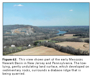
The Piedmont Province can be subdivided topographically into lowland and upland areas. The lowlands are underlain by carbonate rocks (limestone, dolomite, and marble) and by clastic sedimentary rocks in early Mesozoic rift basins; these rocks are easily eroded. Extensive areas of carbonate rocks are concentrated in Pennsylvania; smaller areas are in Maryland. Locally, the early Mesozoic basins contain bodies of igneous rocks, such as basalt flows and diabase dikes and sills collectively called traprock. These igneous rocks are resistant to erosion and form low knobs and ridges (fig. 62) in the lowlands. Most of the province is uplands which are typically low, rounded hills and shallow valleys underlain by a complex assortment of metamorphic and igneous rocks of Paleozoic and Precambrian age. Locally, in such places as Washington, D.C., and Philadelphia, Pa., these crystalline rocks are at low altitudes and have low relief. Major structural lineaments and stratigraphic units strike predominately northeastward, but these alignments are not necessarily reflected by drainage patterns.
The Piedmont surface rises gradually westward to the Blue Ridge Mountain front, the highlands of the Valley and Ridge, or the Reading Prong. The western boundary of the Piedmont is at an average altitude of from 300 to 400 feet in New Jersey and is from 350 to 700 feet above sea level in Pennsylvania. The boundary rises to 700 or 800 feet above sea level in northern Virginia and farther south rises to about 1,500 feet above sea level near the VirginiaNorth Carolina State line.
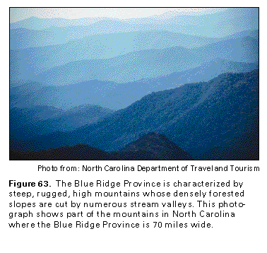
The Blue Ridge Province (including the Reading Prong) in New Jersey and northern Pennsylvania consists of a narrow belt of rounded, gentle knobs of diverse altitude slightly higher than the adjacent Piedmont Province. From southern Pennsylvania to North Carolina, the eastern boundary of the Blue Ridge Province is the Blue Ridge front, which is a single, abrupt slope and commonly is marked by faulting. The Blue Ridge front rises more than 1,700 feet above the Piedmont surface near the North CarolinaVirginia State line and reaches a maximum height of nearly 2,500 feet in central North Carolina. The Blue Ridge Province contains the tallest mountains, highest altitudes (greater than 6,000 feet), and the most rugged topography in eastern North America (fig. 63). The southern part of the province is characterized by steep, forest-covered slopes cut by numerous stream valleys. The valleys of the major rivers include broad, gently rolling areas, as well as narrow gorges. In Segment 11, the province reaches a maximum width of 70 miles in North Carolina. Altitudes are much lower in the northern portion of the province.
Rocks of the Blue Ridge Province and the Reading Prong are, for the most part, many types of metamorphic and intrusive igneous rocks. In New Jersey, Pennsylvania, and North Carolina, however, sedimentary rocks (limestone, dolomite, conglomerate, sandstone, and shale) also are included in the province. In all these rocks, except limestone, dolomite, and marble, which contain solution openings, joints and fractures are the only openings that store and transmit water. The main body of rock between the joints and fractures is almost impermeable.
HYDROGEOLOGIC UNITS
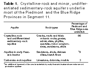
The Piedmont and Blue Ridge Provinces are underlain by three principal types of bedrock aquifers. In order of decreasing area, these are crystalline-rock and undifferentiated sedimentary-rock aquifers, aquifers in early Mesozoic basins, and carbonate-rock aquifers (table 1). Unconsolidated aquifers that are part of the surficial aquifer system overlie the bedrock aquifers locally in Pennsylvania and northern New Jersey.
Crystalline-Rock and Undifferentiated Sedimentary-Rock Aquifers
The most widespread aquifers in the Piedmont and Blue Ridge Provinces in Segment 11 are the crystalline-rock and undifferentiated sedimentary-rock aquifers. These aquifers extend over about 49,000 square miles, or about 86 percent of the area, of these provinces (table 1). Similar aquifers ex-tend southward into Segments 6 and 10 and northward into Segment 12 of this Atlas and are briefly discussed in the chapters describing these segments.
Most of the rocks that compose the crystalline-rock and undifferentiated sedimentary-rock aquifers are crystalline metamorphic and igneous rocks of many types. The main types of crystalline rocks are coarse-grained gneisses and schists of various mineral composition; however, fine-grained rocks, such as phyllite and metamorphosed volcanic rocks, are common in places. Most of the metamorphic rocks were originally sediments; some, however, were igneous rocks or volcan-ic tuff, ash, and lava flows. The degree of heat and pressure to which the original rocks were subjected, the nature of the fluids that have been in contact with the rocks, and the degree of folding and shearing that they have undergone have produced their present texture and mineralogy. Most of the metamorphic rocks have undergone several periods of metamorphism. Locally, they contain highly mineralized zones, some of which are ore bearing. During and after metamorphism, igneous rocks intruded the metamorphic rocks and are present as dikes, sills, and large to small plutons.
The undifferentiated sedimentary-rock aquifers consist of tightly cemented, predominately clastic rocks, many of which grade into metamorphic rocks. Undifferentiated sedimentary rocks are a minor component of the Blue Ridge Physiographic Province and are mainly along the western border of the province in North Carolina. Some of the sedimentary formations are in fault blocks. Most of the undifferentiated sedimentary rocks are of late Precambrian or early Paleozoic age, but in New Jersey, some are as young as middle Paleozoic.
Unconsolidated material called regolith (fig. 64) overlies the crystalline-rock and undifferentiated sedimentary-rock aquifers almost everywhere. The regolith consists of saprolite, colluvium, alluvium, and soil. Saprolite is a blanket of decomposed or partially decomposed rock that is usually thick and clayey, and whose texture varies depending on the type of parent bedrock from which the saprolite is derived. Colluvium is weathered rock material that has slumped downward from hillsides. Alluvium consists mostly of water-transported sediment in stream valleys and channels. Because the regolith material varies greatly in thickness, composition, and grain size, its hydraulic properties also vary greatly. However, the regolith is everywhere more permeable than the underlying bedrock. Water in the bedrock is stored in and moves through fractures, which form the only effective porosity in the unweathered rock.
Aquifers in Early Mesozoic Basins
Aquifers in early Mesozoic rift basins are all within the Piedmont Province and occupy about 9 percent of the combined area of the Blue Ridge and the Piedmont Provinces (table 1). An additional 2 percent of the area of the combined provinces is occupied by the early Mesozoic Durham, Sanford, Wadesboro, and Davie County Basins in North Carolina (fig. 60), but the rocks in these basins are not considered to be significant aquifers. Aquifers in early Mesozoic basins are primarily in three major basins-the Newark Basin in New Jersey and Pennsylvania (fig. 60) is the largest basin and the one from which the most ground water is withdrawn; second largest is the Gettysburg Basin of Pennsylvania and Maryland; and third is the Culpeper Basin of Virginia. The Richmond Basin in Virginia and the Dan RiverDanville Basin in Virginia and North Carolina are of intermediate size. Nine smaller early Mesozoic basins are in Virginia.
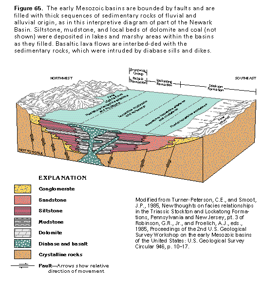
The early Mesozoic basins formed by downfaulting that accompanied rifting of the Earth's crust in the Triassic and Jurassic Periods during incipient stages of continental breakup and are filled mostly with thick sequences of sedimentary rocks (fig. 65). For the most part, major faults border the basins on the west and northwest, and the predominant direction of dip of the sedimentary rocks in the basins is toward these major border faults. Exceptions are the Durham and the Sanford Basins in North Carolina, which are bounded on the east by major faults; the dip of the beds in these basins is to the east or the southeast.
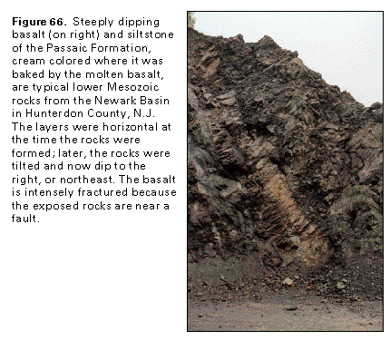
The lower Mesozoic rocks lie unconformably on Precambrian and Paleozoic crystalline rocks, and locally on Paleozoic sedimentary rocks in New Jersey. Sedimentary rocks in the basins consist predominately of interbedded shale, sandstone, and siltstone, all typically red, reddish brown, or maroon but locally gray or black. Conglomerate, dolomite, lacustrine black mudstone, and coal are present locally. In many places, the sedimentary rocks are interbedded with basalt flows (figs. 65 and 66) or have been intruded by diabase dikes and sills. Thicknesses of Triassic and Jurassic rocks in the larger basins have been calculated to be more than 20,000 feet.
Deposition of sediments in the early Mesozoic basins was controlled by a combination of intermittent faulting and subsidence of the basins, altitude of the bordering highlands, climate, and drainage patterns. A tropical climate prevailed in the basins during Triassic and Jurassic time. Temperatures were high and rainfall varied, but tended to be low. Sediments deposited in lakes later became siltstone and mudstone, those deposited in swamps became black mudstone and coal, and river deposits and alluvial fans became sandstone and conglomerate. Lake levels varied; some lakes dried up seasonally, and the exposed sediment was oxidized and turned red. The sediments show evidence of cyclic repetition, which has been attributed to periodic changes in the Earth's climate.
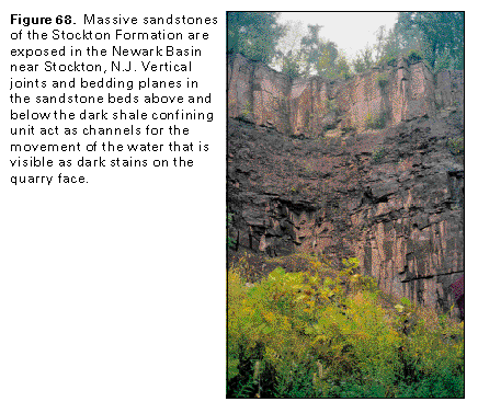
The Newark Basin (fig. 60) extends from the Hudson River Valley to the divide between the Schuylkill and the Susquehanna Rivers in Pennsylvania. The Newark Basin contains three principal stratigraphic units. From oldest to youngest, these are the Stockton Formation of Triassic age, which is mainly soft feldspathic sandstone, shale, and some conglomerate; the Lockatong Formation of Triassic age, which is predominately gray and black siltstone and shale; and the Brunswick Group of Jurassic and Triassic age, which contains argillite, shale, siltstone, sandstone, conglomerate, and three basalt units. The igneous rocks that occur as sills and flows parallel to and interbedded with the sedimentary beds and as dikes and stocks that cut across them are resistant to erosion, and form hills. The Lockatong Formation, which is the least productive water-yielding sedimentary rock in the basin, is more resistant to erosion than the other sedimentary rocks and also underlies low hills.
The Gettysburg Basin stretches from the narrow neck that connects it to the Newark Basin about 80 miles westward and southward to near Frederick, Md. (fig. 60). The New Oxford Formation of Triassic age, which is composed of feldspathic sandstone, siltstone, and shale, is the lowermost formation in the Gettysburg Basin and is overlain in most places by red shale, siltstone, and fine sandstone of the Gettysburg Formation of Triassic and Jurassic age. The conglomeratic Hammer Creek Formation of Triassic age overlies the New Oxford Formation in the narrow neck between the Newark and the Gettysburg Basins. Basalt flows occur in the upper part of the Gettysburg Formation.
The Culpeper Basin of northern Virginia and adjacent Maryland (fig. 60) is an elongate, fault-bounded trough that trends north-northeast from the southern border of Madison County, Va., about 90 miles to Frederick County, Md. All the formations in the basin are part of the Culpeper Group. The lower part of the group consists of sandstone, siltstone, and conglomerate of Late Triassic age; the upper part consists of Lower Jurassic sedimentary rocks and interbedded basaltic lava flows.
The Richmond Basin stretches from just north of Richmond, Va., 35 miles south to the DinwiddieAmelia County border (fig. 60). The lowest stratigraphic unit in the basin is the Middle Triassic Tuckahoe Group, which contains siltstone, shale, and coal beds. It is overlain by the Upper Triassic Chesterfield Group, which consists of black shale and sandstone of the Vinita beds and the Otterdale Sandstone. The sedimentary rocks are cut by a few Late Jurassic diabase dikes. Small outliers near the Richmond Basin may have been connected to the original basin because they consist of similar rocks.
The Dan RiverDanville Basin extends from southern Appomattox County, Va., about 100 miles southwest into Stokes County, N.C. In Virginia, the basin is named Danville, and in North Carolina, Dan River. The basin contains sedimentary rocks of the Upper Triassic Dan River Group; in Virginia, the Dry Fork Formation is also present. The sedimentary rocks consist of sandstone, siltstone, mudstone, shale, and local conglomerate and are locally cut by diabase dikes.
Rocks in the four southernmost early Mesozoic basins in North Carolina contain water sufficient only for domestic supplies in the upper 300 feet. The rocks are similar in composition but are more compact and tightly cemented than those in the basins to the north and do not yield sufficient quantities of water to be considered a principal aquifer.
Limestone, dolomite, and marble of Paleozoic and Precambrian age form carbonate-rock aquifers that extend over about 3 percent of the Piedmont and the Blue Ridge Provinces in Segment 11. Although these carbonate rocks are of small extent, they are significant local sources of water. Carbonate-rock aquifers are in five areas of the Piedmont and the Blue Ridge Provinces of Segment 11 (fig. 60). In addition to these areas, small, isolated elongate stringers of limestone and marble form minor aquifers locally, particularly in Virginia, and generally trend parallel to the Blue Ridge front.
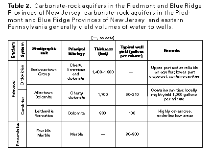
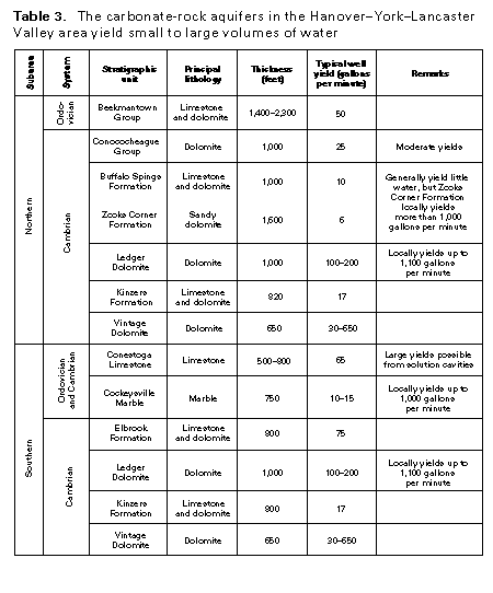
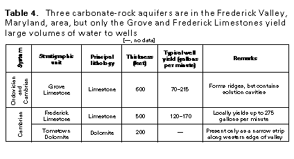
In northern New Jersey and eastern Pennsylvania (fig. 60, Area 1), Precambrian and lower Paleozoic carbonate rocks are interspersed with granite and gneiss of the Reading Prong and locally have been juxtaposed by faults with lower Mesozoic rocks of the Newark Basin in Pennsylvania. These carbonate rocks form a series of long, narrow blocks in the noncarbonate rocks that surround them. The major faults and other geologic structures generally trend northeastsouthwest but have been tilted or rotated in some areas so that they trend northwest-southeast. The principal water-yielding units are listed in table 2. A large area of carbonate rocks is centered in the HanoverYorkLancaster Valley area of Pennsylvania (fig. 60, Area 2). The lithology and water-yielding characteristics of the principal carbonate-rock formations are listed in table 3. Three carbonate-rock formations (table 4) are present in Area 3, which encompasses the Frederick Valley in Frederick County, Md., and extends northward into Pennsylvania (fig. 60). Small areas of carbonate rock in Area 4 (fig. 60) include those underlain by the Cockeysville Marble of Ordovician and Cambrian age in southern Chester County, Pa., in Baltimore and Howard Counties, Md., and New Castle County, Del. Carbonate rocks of Cambrian age in North Carolina are exposed mostly in two windows, or openings, that were eroded through major thrust sheets to expose the underlying rock in Area 5 (fig. 60). The exposed rocks are the Shady Dolomite and the Rome Formation in the Hot Springs Window in Madison County and the Shady Dolomite in the Grandfather Mountain Window in northern McDowell County. An elongated outcrop of the Cambrian or Precambrian Murphy Marble in Cherokee County, N.C., is in a structural fold.
GROUND-WATER FLOW AND WELL YIELDS
Recharge is highly variable in the Blue Ridge and the Piedmont Provinces because it is determined by local precipitation and runoff, which are highly variable and are influenced by topographic relief and the capacity of the land surface to accept infiltrating water. The greatest annual precipitation and runoff in Segment 11 are in the Blue Ridge Province, notably in southwestern North Carolina. Because the western part of the Piedmont Province from North Carolina to central Virginia is in the rain shadow of the Blue Ridge Mountains, it receives less precipitation than areas on either side.
Most of the Piedmont and the Blue Ridge Provinces are covered by regolith. Compared to the Blue Ridge, the gentler topographic relief of the Piedmont and less precipitation make the Piedmont less subject to rapid denudation than the Blue Ridge and thus favor the accumulation of a thicker regolith. The combination of large areas of thin regolith and dense bedrock with minimal permeability in the Blue Ridge Province do not favor large amounts of ground-water recharge.
Most of the recharge in the Piedmont and the Blue Ridge Provinces takes place in interstream areas. Almost all recharge is from precipitation that enters the aquifers through the porous regolith. Much of the recharge water moves laterally through the regolith and discharges to a nearby stream or depression during or shortly after a storm or precipitation event. Some of the water, however, moves downward through the regolith until it reaches the bedrock where it enters fractures in crystalline rocks and sandstones or solution openings in carbonate rocks.
Crystalline-Rock Aquifers
In crystalline-rock areas, the regolith and fractures in the bedrock serve as the principal places for the storage transmission of water, and ground-water movement is generally along short flow paths from interstream recharge areas to the nearest stream. This situation applies to most of the Piedmont and the Blue Ridge Provinces. Where bedrock fractures have one or more preferred directions of orientation, as is often the case, ground water will tend to flow more readily in the direction of the fractures; this is a condition called anisotropy.
An example of anisotropy is shown by the results of an aquifer test performed on wells completed in crystalline rocks of the Piedmont Province near Greensboro, N.C. (fig. 67). The contours in the figure are lines of equal water-level decline measured in numerous observation wells after a production well with a 6-inch diameter had been pumped for 57 hours at a rate of about 39 gallons per minute. This well was completed in fractured gneiss; the joints and fractures in the rock trend northeast. The contours that show water-level decline form an oval shape that is elongated to the northeast, which indicates that the bedrock is more permeable in that direction.
Aquifers in Early Mesozoic Basins
The rocks of the early Mesozoic basins include beds of sandstone, arkose, and conglomerate that originally had considerable effective porosity between the grains. However, due to compaction and cementation, the pores in most of these strata are now reduced in size and poorly interconnected, so that only a small part of the ground water moves between pores. The diabase and basalt that intrude the sedimentary rocks had very low primary porosity. The ground water in the lower Mesozoic rocks moves primarily along joints, fractures, and bedding planes. The water-bearing fractures and bedding planes in each tabular aquifer are more or less continuous, but the hydraulic connection across the confining units between individual aquifers is poor (fig. 68). Because of preferential alignment of these openings, the aquifers are anisotropic; most of the water movement is parallel to the strike of the beds.
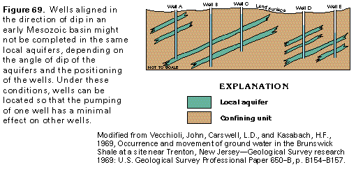
Because some sedimentary rocks contain more interconnected openings than others, the ground-water system in the early Mesozoic basins consists of a series of aquifers of tabular form that alternate with confining units that are several tens of feet thick. The aquifers and confining units dip toward the border faults that bound the basins at angles that range from 10 to 15 degrees. The aquifers generally extend downdip for a few hundred, rarely for a few thousand, feet but are continuous along strike for thousands of feet. Wells drilled perpendicular to the strike of the beds might penetrate separate aquifers (fig. 69), depending on the angle of the dip of the aquifers and the spacing of the wells. Consequently, well fields designed with wells aligned perpendicular to the strike would likely have minimum interference between wells. Wells B and C in figure 69 are completed in the same local aquifers, and each well, when pumped, will interfere with the other. By contrast, wells C and D are not completed in the same aquifer, and pumping either well will not affect water levels or well yields in the other well.
The aquifers in the early Mesozoic basins north of North Carolina generally yield more water than other noncarbonate aquifers in the Piedmont and the Blue Ridge Provinces, possibly because the original, intergranular pore space in the Meso-zoic rocks may be sufficient to store and transmit appreciable quantities of water. The lower Mesozoic rocks make up some of the few aquifers in the Piedmont and the Blue Ridge Provinces in which the yield per foot appears to increase with depth. In the Pennsylvania part of the Newark Basin, wells between 200 and 550 feet deep are most likely to obtain maximum yields; the average yield of wells deeper than about 200 feet is distinctly higher than that of shallower wells. This may be the result of a rather abrupt change in the nature of rock weathering at depth. In Pennsylvania, the zone of greatest decomposition of the rock-the zone where the original void spaces are believed to be partly plugged with residual clay-apparently is above 200 feet. In Maryland, some water-yielding zones are at depths of between 600 and 900 feet in aquifers of the early Mesozoic basins.
The dikes in the early Mesozoic basins resemble walls of diabase that are nearly vertical through the sedimentary rocks into which they are intruded. The dikes themselves generally yield little water, but in many places, the strata adjacent to the dikes have been made brittle by baking from the heat of the dike and have been fractured by the intrusion. The dikes also function as dams because they block ground-water flow and tend to impound water in the sediments on their upgradient sides. In many places, wells drilled near dikes produce more water than wells drilled elsewhere in lower Mesozoic strata.
Typical yields of large-diameter wells in the Newark and the Gettysburg Basins of Pennsylvania are generally greatest (about 80 gallons per minute) from wells completed in massive sandstones and 0 conglomerates and are least (about 5 gallons per minute) from wells completed in diabase. Yields of wells completed in shale or argillite are typically about 12 gallons per minute. Although limestone and dolomite conglomerate is the largest-yielding aquifer (median yield 30 gallons per minute from wells 250 to 500 feet deep) in the Culpeper Basin of Maryland and Virginia, noncarbonate conglomerates tend to be mediocre aquifers (median yield 8 gallons per minute for the same depth range), probably because they are tightly cemented. Thin-bedded siltstone tends to yield more water than sandstone (75 gallons per minute versus 15 gallons per minute).
Many wells completed in aquifers in the early Mesozoic basins yield large quantities of water during pumping tests that range from 24 to 48 hours but fail to maintain large yields over long periods of time. The yields of several wells that were tested at 75 gallons per minute soon after completion declined in a few years to about 15 gallons per minute. These wells might have been completed in aquifers that did not contain much water in storage and had low rates of recharge. Another possibility is that after a period of pumping, some of the fractures in the aquifers might have been partly closed by clay and silt that were disturbed and transported by the pumping action or by the precipitation of minerals from the water.
Carbonate-Rock Aquifers
Carbonate rocks are soluble in weak acid solutions compared to rocks of other composition. Water that percolates downward through the soil contains small amounts of dissolved carbon dioxide and organic acids, which make the water weakly acidic and thus capable of dissolving carbonate minerals. Dissolution commonly begins along pre-existing openings, such as fractures or bedding planes, and enlarges these openings to form a network of interconnected openings, which greatly increases the porosity and permeability of the rock. A well that intersects a water-filled solution channel or cavern will produce an abundant supply of water. However, where the water table is deep, the cavities are mostly drained. Not all carbonate rocks form productive aquifers. The water-yielding character of these rocks depends on the degree of fracturing and dissolution of the rocks.
The carbonate rocks of the Piedmont and the Blue Ridge Provinces have virtually no primary permeability or porosity, and water in these rocks moves through secondary openings, such as bedding planes, joints, faults, and other partings, within the rock that have been enlarged by dissolution. In rocks that have a large content of sand, clay, or other noncarbonate minerals, dissolution is inhibited and enlargement of openings might not be extensive. In such rocks, all the water might occur in fracture openings similar to those in unweathered crystalline rocks.
Ground water in carbonate rocks is under unconfined to confined conditions. The water is confined or semiconfined in the regolith and in the zone of fractured rock that immediately underlies it. Deep fractures and solution channels in the unweathered rock contain semiconfined to confined water and, in some places, transmit water several tens of miles from recharge areas to discharge areas.
Data on the regional hydraulic properties of the carbonate-rock aquifers are not available. From the observed behavior of pumped wells completed in confined carbonate-rock aquifers and the effects of the pumping on adjacent wells, however, it appears that a decline of artesian pressure in response to pumping generally is transmitted rapidly to distant points, but the decline is seldom equal in all directions. In fact, closely spaced wells might encounter different systems of rock openings, in which case pumping from one well will not affect the water levels in an adjacent well.
Even though cavities in carbonate rocks commonly contain an abundant supply of water, they also might contain large amounts of exceedingly fine mud that must be removed or stabilized before clear water can be obtained from the cavities. Solution cavities also can act as channels for the transmission of sewage, surface contaminants, or other types of pollution.
RELATION OF HYDROGEOLOGIC SETTING AND WELL YIELD
Several factors affect the yields of wells completed in the rocks of the Piedmont and the Blue Ridge Provinces. Variations in yield depend on the type of rock in which a well is completed; the thickness of the regolith; the number, size, and spacing of bedrock fractures and the degree to which the fractures are connected; and the topographic setting of the well.
The largest sustained well yields can be obtained from carbonate-rock aquifers, whereas the smallest sustained yields generally are from crystalline-rock and undifferentiated sedimentary-rock aquifers. Aquifers in early Mesozoic basins yield intermediate volumes of water. Well yields for all types of crystalline rocks generally are small; a recent study showed an average yield of 18 gallons per minute for wells completed in these rocks in North Carolina. Coarse-textured crystalline rocks, such as gneiss and schist, generally yield more water than fine-grained, metavolcanic rocks.
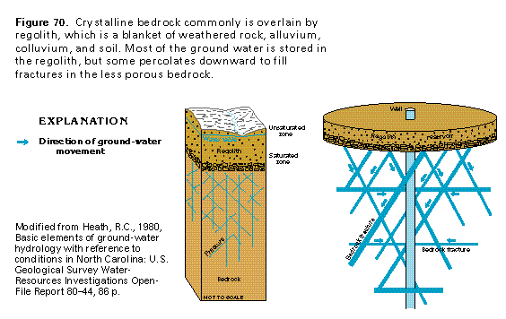
Crystalline bedrock is covered by a thick to thin layer of regolith almost everywhere in the Piedmont and the Blue Ridge Provinces. Although the porosity of the regolith varies, depending mostly on the type of bedrock, it is everywhere more porous than the bedrock. The porosity of the regolith ranges from about 20 to 30 percent, but the porosity of the bedrock ranges from only about 0.01 to 2 percent. Accordingly, the regolith has the capacity to store a much larger volume of water than the bedrock, which contains water only in fractures, as shown in figure 70. The cylinder-and-rod sketch on the right of the figure illustrates this concept. Most of the water is stored in the regolith reservoir, which is represented by the cylinder, from which a small part of the water moves downward and is stored in bedrock fractures, which are represented by the interconnected rods. The size, number, and interconnection of the fractures decrease with depth. The thicker the regolith, the greater the volume of water in storage and the more likely well yield can be sustained. Where the regolith is thin, crystalline-rock wells are more likely to go dry during the summer months or periods of drought.
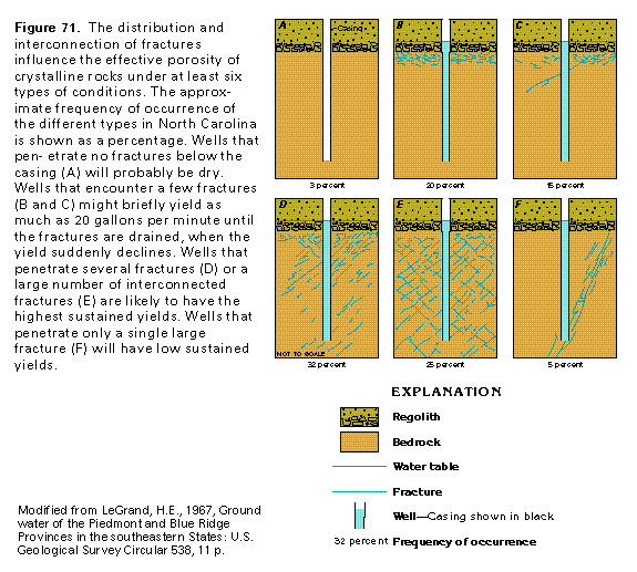
Most of the fractures in crystalline rocks or consolidated sedimentary rocks are steeply inclined, intersecting openings that are more numerous at shallow depths. Examples of some of the possible distributions of fractures with respect to wells that are completed in crystalline rocks are shown in figure 71. Only about 3 percent of wells encounter no fractures (fig. 71A) and are either dry or will not have a sustained yield. Where the rock is fractured only near the surface (figs. 71B and C), wells will yield from 10 to 20 gallons per minute for a short time until the fractures are drained, when well yield suddenly declines. Where several fractures connected to the regolith are penetrated by a well (fig. 71D), moderate sustained yields are possible, whereas a well that encounters numerous closely spaced fractures (fig. 71E) is most likely to have a high sustained yield. Where only a few fractures exist (fig. 71F), sustained yields are likely to be low. When the water level in a well that was completed in rocks with intergranular porosity is lowered by pumping, the hydraulic gradient toward the well is increased, and the flow toward the well also is increased. However, if the water level is lowered below the deepest fracture in the examples shown, then there is no effect on the gradient, and flow toward the well will not increase.
The Piedmont and the Blue Ridge Provinces contain many faults, most of which show only small displacement. The fault zones themselves commonly have low permeability because they can be filled with clay gouge, recemented breccia, or recrystallized rock, all of which impede the flow of ground water. Most of the water-bearing fractures in the Piedmont and the Blue Ridge are joints, stress-relief fractures, or cleavage planes and are not directly associated with a fault. Some fracture zones appear as lineaments that can be identified on aerial photographs.
Wells in valleys, draws, and depressions tend to have higher-than-average yields for the following reasons: (1) valleys and draws commonly coincide with fracture zones in the rocks, (2) the water table is nearer the surface in topographically low areas and thus provides greater available drawdown for a given well depth in a valley than on a hill, (3) the water table ordinarily slopes toward wells in valleys from at least two directions, whereas it slopes away from wells on hilltops in at least two directions, and water levels in wells on hilltops, therefore, are more likely to decline rapidly than those in wells in valleys, and (4) seasonal fluctuations of the water table are greater on hilltops where well yields are likely to be reduced during dry seasons. Draws on the sides of the valleys of per-ennial streams where a thick blanket of regolith underlies the adjacent ridges are the best sites for wells with large yields. A statistical analysis that related well yield to topographic setting in the Piedmont and the Blue Ridge Provinces of North Carolina indicated that wells drilled in valleys or draws have average yields that are three times those of wells located on hills or ridges. Solution openings in carbonate rocks are usually more abundant in valleys, depressions, and draws, which are, therefore, favorable sites for wells in this type of rock.
Ground-water discharge to a stream (base flow) is an indi-cation of the maximum sustained ground-water yield. The per-centage of streamflow composed of base flow is determined by the infiltration capacity of the soil and the capacity of the underlying aquifers to store and transmit water. In part of the Piedmont Province in southeastern Pennsylvania, base flow ranges from 57 to 66 percent of streamflow in drainage basins that are underlain predominately by crystalline rocks and 77 percent in a typical basin that is underlain by carbonate rocks. Base flow ranges from 33 to 67 percent of streamflow in three drainage basins that are underlain by crystalline rocks in the Piedmont and the Blue Ridge of Maryland and from 32 to 65 (average 44) percent in 10 crystalline-rock drainage basins in the Piedmont of North Carolina. The average base flow in the early Mesozoic Culpeper Basin of Maryland and Virginia is 68 percent of streamflow.
GROUND-WATER QUALITY
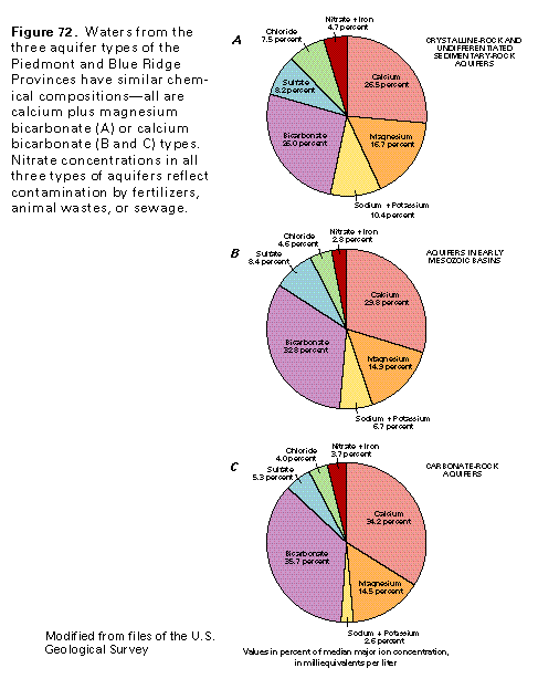
The quality of water from aquifers in the different rock types of the Piedmont and the Blue Ridge Provinces is similar (fig. 72). The water generally is suitable for drinking and other uses, but iron, manganese, and sulfate locally occur in objectionable concentrations. Large iron concentrations can be caused by corrosion or the action of iron-fixing bacteria on iron and steel casings and well fittings. Some crystalline rocks and some sedimentary rocks in early Mesozoic basins contain minerals that, when weathered, can contribute iron and manganese to ground water, particularly if the water is slightly acidic. Treatment of the water usually will alleviate problems of excessive iron and manganese concentrations.
The crystalline-rock and undifferentiated sedimentary-rock aquifers consist primarily of metamorphic and igneous rocks but include small areas of sedimentary rocks, principally conglomerate, sandstone, and shale. These rocks consist mostly of silica and silicate minerals that are not readily dissolved. Dissolved-solids concentrations in water from these aquifers average about 120 milligrams per liter. The water is soft; hardness averages about 63 milligrams per liter. The median hydrogen ion concentration, which is measured in pH units, is 6.7; consequently, the water is slightly acidic. The median iron concentration is 0.1 milligram per liter, but concentrations as large as 25 milligrams per liter have been reported. The water is mostly a calcium plus magnesium bicarbonate type (fig. 72A).
The aquifers in early Mesozoic basins are mostly sandstone, siltstone, and shale, with some limestone and conglomerate. The minerals that compose these rocks are slightly more soluble than those of the rocks that compose the crystalline-rock and undifferentiated sedimentary-rock aquifers. Dissolved-solids concentrations in water from the aquifers in early Mesozoic basins average about 230 milligrams per liter, and hardness averages about 160 milligrams per liter, which is considered to be hard. The median hydrogen ion concentration, which is measured in pH units, is 7.6. The dissolution of calcium and magnesium carbonate raises the pH of the water and renders it less acidic. Chloride and sulfate concentrations average about 12 and 29 milligrams per liter, respectively, but chloride concentrations as large as 1,400 milligrams per liter and sulfate concentrations as large as 1,200 milligrams per liter have been reported in water from deep wells. The median iron concentration is 0.1 milligram per liter, but concentrations as large as 5.3 milligrams per liter have been reported. The water from the aquifers in early Mesozoic basins is mostly a calcium bicarbonate type (fig. 72B).
The dominance of soluble calcium and magnesium carbonate minerals in the carbonate-rock aquifers is reflected in the composition of the water from the aquifers. Dissolved-solids concentrations in the water average about 330 milligrams per liter, and hardness (caused principally by calcium and magnesium ions) averages about 280 milligrams per liter, which is considered to be very hard. The median hydrogen ion concentration, which is measured in pH units, is 7.5. The median iron concentration is 0.1 milligram per liter, but concentrations as large as 8 milligrams per liter have been reported. The water is mostly a calcium bicarbonate type (fig. 72C).
FRESH GROUND-WATER WITHDRAWALS
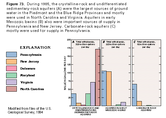
Total freshwater withdrawals from the bedrock aquifers of the Piedmont and the Blue Ridge Provinces were about 634 million gallons per day during 1985. About 52 percent of the otal, or about 329 million gallons per day, was withdrawn from the crystalline-rock and undifferentiated sedimentary-rock aquifers. Withdrawals from the aquifers in early Mesozoic basins were about 223 million gallons per day, or about 35 percent of the total. The remaining 13 percent, or about 82 million gallons per day, was withdrawn from the carbonate-rock aquifers.
The distribution of withdrawals from the three types of bedrock aquifers varies greatly from State to State (fig. 73). More than one-half of the water withdrawn from the crystalline-rock and undifferentiated sedimentary-rock aquifers during 1985 was pumped in North Carolina (fig. 73A). The aquifers in early Mesozoic basins (fig. 73B) were important sources of supply in Pennsylvania and New Jersey during the same period. Withdrawals from the carbonate-rock aquifers during 1985 were greatest in Pennsylvania (fig. 73C). The withdrawals are directly proportional to the area underlain by each bedrock aquifer type in each State.
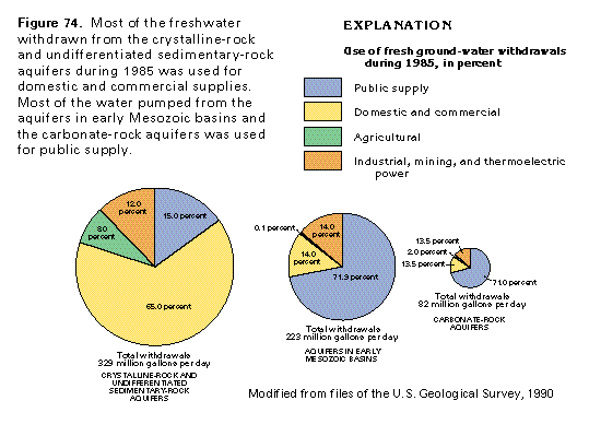
Withdrawals for different uses during 1985 varied among the bedrock aquifer types (fig. 74). Most of the water withdrawn from the crystalline-rock and undifferentiated sedimentary-rock aquifers was used for domestic and commercial supplies. By contrast, most of the water withdrawn from the aquifers in early Mesozoic basins and the carbonate-rock aquifers was used for public supply. The percentage of water withdrawn for industrial, mining, and thermoelectric power uses was nearly the same for all three aquifer types. Agricultural withdrawals were the smallest use category for each of the three aquifer types.