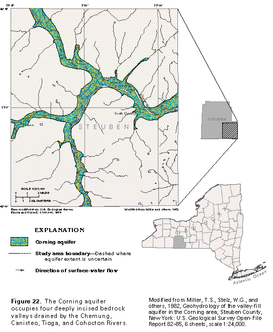
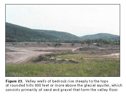
The Corning aquifer is an example of a valley-fill glacial aquifer deposited by meltwater streams that drained away from stagnated or melting glacial ice in upland valleys. It is characteristic of many such glacial-drift aquifers in the Appalachian Plateaus. The aquifer occupies four deeply incised bedrock valleys formed by the junction of the Chemung River and its principal tributaries, the Canisteo, the Tioga, and the Cohocton Rivers, in southeastern Steuben County, N.Y. (fig. 22). The valleys are incised deeply into flat-lying shaly carbonate bedrock. Valley walls rise steeply to rounded hill tops 800 feet or more above the valley floor (fig. 23) and about 1,800 feet above sea level.
The flat-lying valley floor is the site of the city of Corning and the villages of Addison, Painted Post, Riverside, and South Corning (fig. 22). Numerous homesites dot the rural landscape. About 31,000 people in the mapped area depend on ground water for water supplies. The city of Corning is the site of a major glass industry, which is a principal water user in the area.
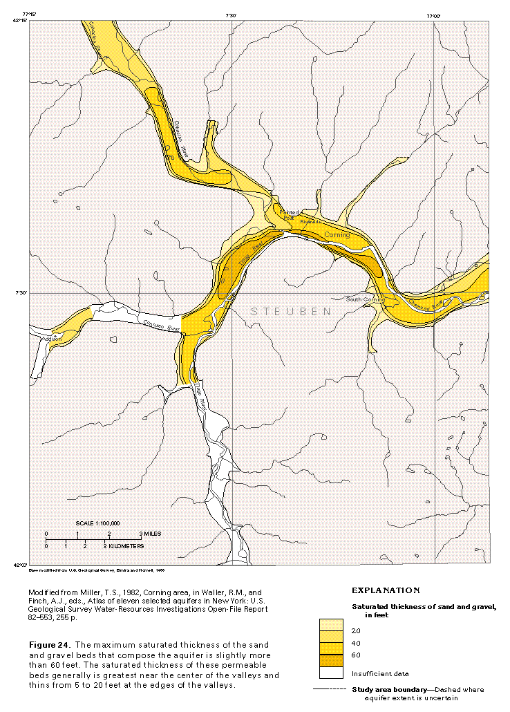
The Corning aquifer extends over an area of about 28 square miles in valleys 0.5 to 1 mile wide. The maximum saturated thickness of the sand and gravel beds of the aquifer is slightly more than 60 feet and generally ranges between 20 and 60 feet (fig. 24). On the east, the aquifer is continuous with a similar valley-fill glacial aquifer.
GEOLOGY
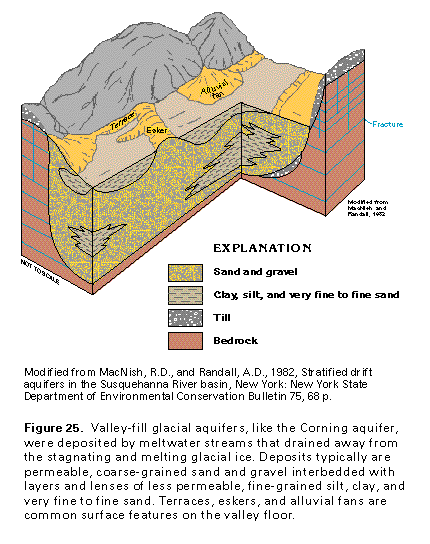
The Corning area is located in the Appalachian Plateaus Province of southwestern New York. Bedrock underlying the area is flat-lying shale, limestone, siltstone, and sandstone that was deeply eroded by preglacial drainage. Preglacial erosion was enhanced by glacial scour that broadened and deepened the valleys and rounded off the hill tops (fig. 23). Till was deposited as a veneer on the hill tops and valley walls during advances of the glacial ice. When the glacial ice melted, the bedrock valleys became the resting place for stagnating ice and were the natural drainageways for meltwater that deposited ice-contact and outwash deposits, which consisted primarily of sand and gravel during peak ice-melting periods, and glacial-lake deposits, which consisted primarily of clay, silt, and very fine to fine sand during quiescent periods. Some of the till was eroded and carried as sediment into the valley where it formed alluvial fans as the tributary streams deposited sediment onto the valley floor. The last retreat of the glacial ice left the bedrock valleys partially filled with sand and gravel intermixed with fine grained glacial-lake deposits. Terraces, eskers, alluvial fans, and other features also were left on the land surface, as shown in figure 25.
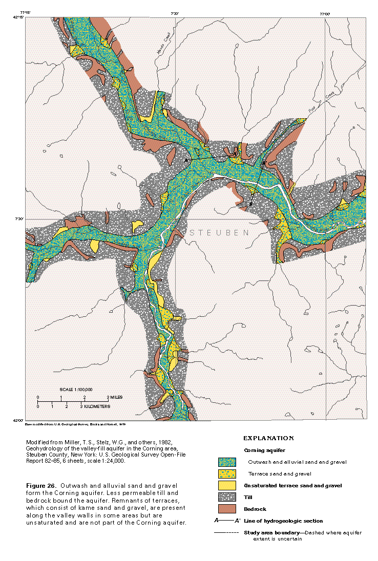
Since the last retreat of the glacial ice, the streams in the valleys have eroded and redeposited some of the glacial deposits; as a result, outwash and alluvial sand and gravel cover the floor of the main and the tributary valleys (fig. 26). Till lines the valley walls along much of the Canisteo and Chemung Rivers. Bedrock forms the valley walls along much of the Cohocton River and intermittently elsewhere. Remnants of terraces are present on the valley walls chiefly along the Canisteo and the Tioga Rivers and along Meads Creek. Although the terraces consist of sand and gravel, these deposits generally are unsaturated and not considered to be part of the Corning aquifer.
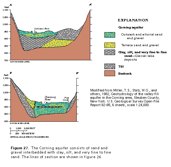
Sections A-A' and B-B' in figure 27 show some of the many possible relations among the deposits that form the Corning aquifer. The sections also show the till plastered on the valley walls and its relation to the Corning aquifer.
HYDROLOGY
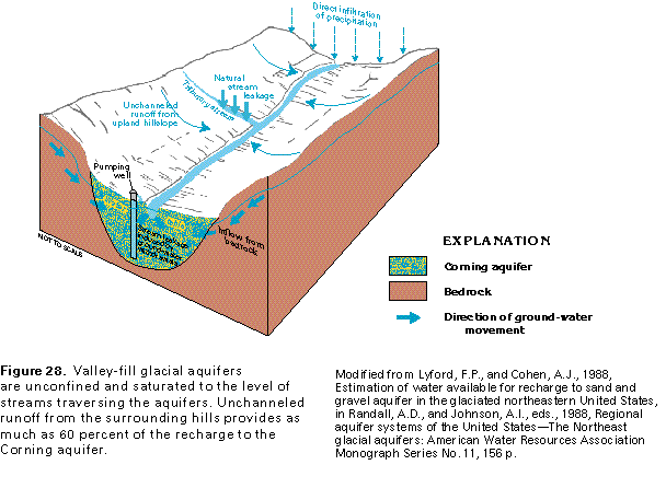
Sand and gravel deposits of the Corning aquifer generally are unconfined and saturated to the level of the streams that traverse them; thus, in most places they are saturated nearly to land surface. Some recharge to the aquifer is by infiltration of precipitation that falls directly on the aquifer; however, about 50 percent of the precipitation is returned to the atmosphere by evapotranspiration. Recharge also takes place by inflow from the adjacent bedrock and by downvalley movement of water through the aquifer (fig. 28). Studies have concluded that as much as 60 percent of the recharge to the aquifer is from runoff of precipitation that falls on the surrounding hills that are underlain by low permeability till and bedrock. Unchan-neled upland runoff recharges the aquifer by direct infiltration at the valley wall. Where tributary streams flowing in bedrock channels begin to flow over the alluvial fan and outwash deposits of the aquifer, the water level in the streams is commonly higher than that of the water table in the underlying aquifer, and water moves from the stream into the permeable sand and gravel. Withdrawal of water from the aquifer by wells lowers the water table locally and might induce additional leakage of water from streams to the aquifer, thus providing an additional source of recharge near well fields.
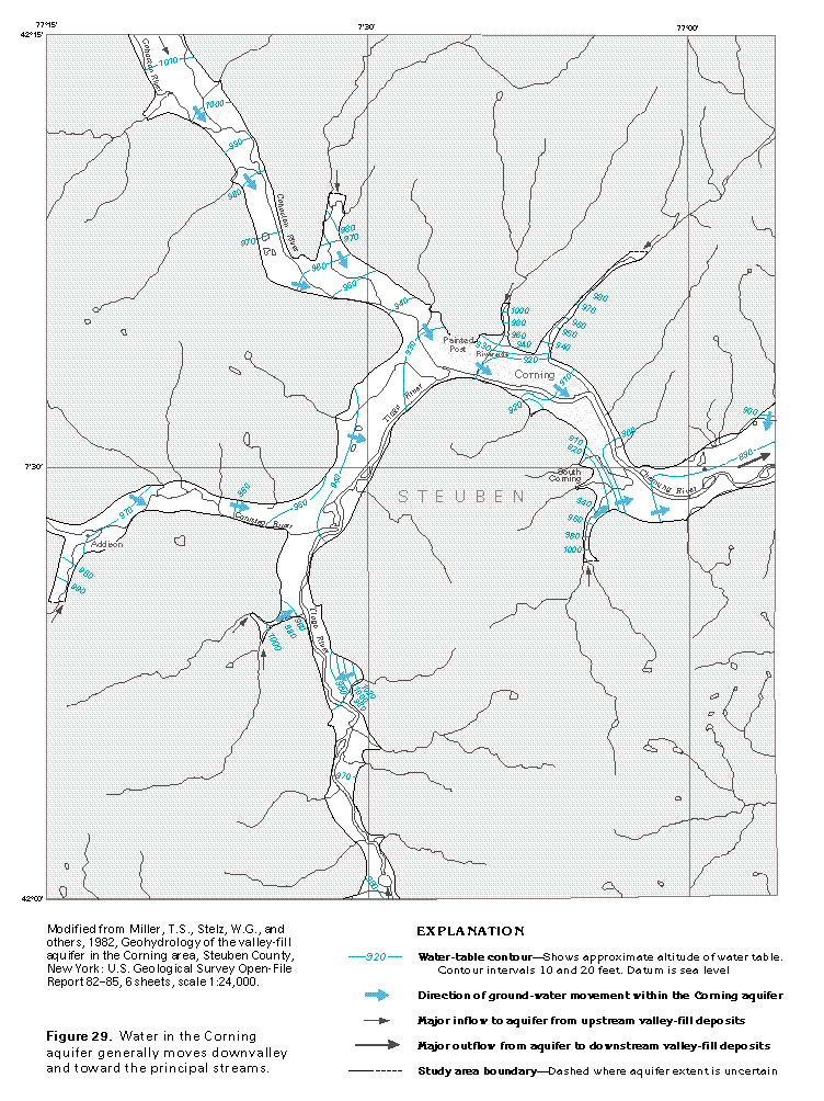
Water in the Corning aquifer generally moves downvalley and toward the principal streams, as shown in figure 29. However, near losing tributary streams, such as those north of Corning, ground-water movement is away from the tributary and into the aquifer.
Water discharges from the Corning aquifer to the principal streams throughout the length of the system as indicated by the shape of the water-table contours in figure 29. The ground-water discharge provides the base flow of the streams and sustains flow during periods of no precipitation. Much of this water can be captured by wells that intercept water that otherwise would move to the streams. Water also is discharged from the aquifer as underflow at the downgradient end of the valley (fig. 28).
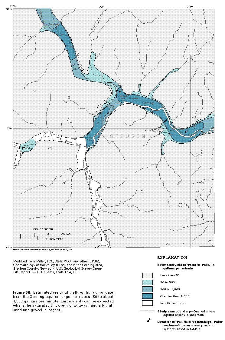
Estimated yields of wells completed in the Corning aquifer range from about 50 to about 1,000 gallons per minute (fig. 30). The largest yields can be expected in three areas: from Painted Post to east of South Corning in the Chemung River Valley, from near Erwins to near Gang Mills in the Tioga River Valley, and southeast of Campbell in the Cohocton River Valley. Large yields can be expected from outwash and alluvial deposits that consist largely of sand and gravel where the saturated thickness is more than 40 feet. In areas where the sand and gravel is thinner or where fine-grained glacial-lake deposits are present, yields are less. Little is known about the area east of Addison in the Canisteo River Valley and the area in the Tioga River Valley upstream from Erwins.
GROUND-WATER QUALITY
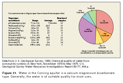
The chemical quality of water from the Corning aquifer generally is suitable for most uses. Dissolved-solids concentrations in five representative samples of the water averaged 212 milligrams per liter and ranged between 146 and 282 milligrams per liter (fig. 31). The water is a calcium magnesium bicarbonate type; these ions constitute 77 percent of the dissolved ions in the water. The water typically is alkaline (pH of greater than 7.0) and very hard (hardness as calcium carbonate, greater than 180 milligrams per liter); excessive iron and manganese concentrations are a nuisance in some areas, but the water can be easily treated to remedy these problems.
FRESH GROUND-WATER WITHDRAWALS
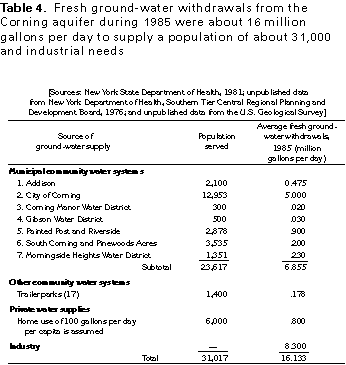
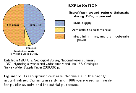
Fresh ground-water withdrawals from the Corning aquifer during 1985 totaled about 16 million gallons per day to supply industrial needs and a population of about 31,000 (table 4). Industrial, mining, and thermoelectric power uses accounted for about 8.3 million gallons per day, or about 51 percent of the total use (fig. 32), which largely was used to supply industry in the city of Corning. Public supply for the city of Corning, 5 communities, 3 water districts, and 17 trailer parks, accounted for about 7 million gallons per day, or about 44 percent of the total use. Domestic and commercial withdrawals accounted for about 0.8 million gallons per day, or about 5 percent of the total use.
LITTLE ANDROSCOGGIN RIVER VALLEY AQUIFER
The Little Androscoggin River Valley aquifer is an example of a valley-fill glacial aquifer deposited by meltwater streams that flowed away from stagnated or melting glacial ice in lowland bedrock valleys that were either partly or completely inundated by the ocean. The glacial material was deposited contemporaneously with and partly atop marine silt and clay in the southern one-half of the bedrock valley.
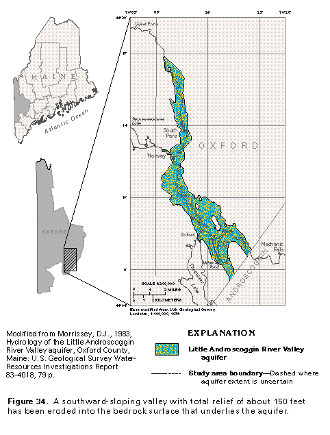
The aquifer occupies a deeply incised preglacial valley eroded into granitic bedrock in southeastern Oxford County, Maine (fig. 33). Valley walls rise from 200 to 300 feet above the flat-lying valley floor to the crests of gently rounded hills. The valley walls and the hills are blanketed by glacial till.
The Little Androscoggin River Valley aquifer extends southward from about 2 miles south of West Paris to about 2 miles west of Mechanic Falls, which is a distance of about 14 miles. The aquifer varies in width from less than 1 mile to slightly more than 2 miles and has an estimated area of about 16 square miles. The towns of South Paris, Norway, and Oxford are located partly or entirely on the aquifer and use water from it for municipal supply. In addition, numerous rural homesteads withdraw water from the aquifer for domestic and stock-watering purposes.
GEOLOGY
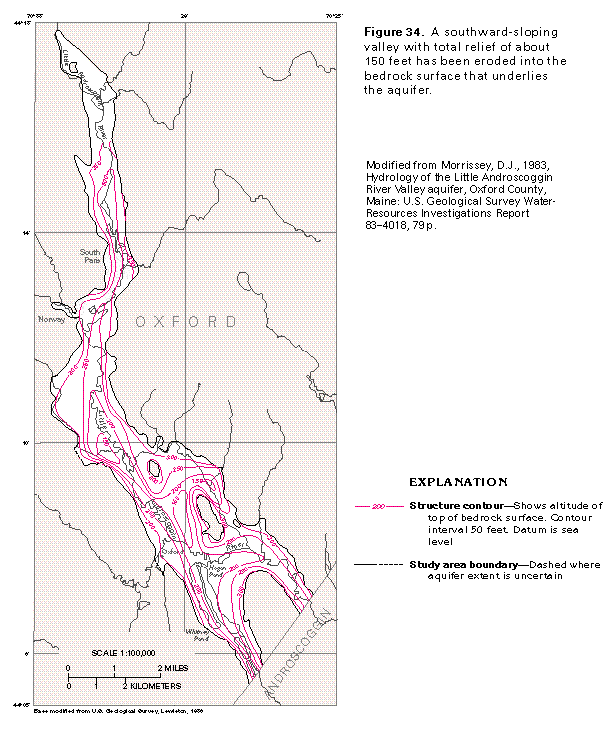
Bedrock underlying the Little Androscoggin River Valley aquifer is predominantly granite. Although the bedrock has minimal permeability and acts as a boundary to water movement, it is fractured, and the fractures will transmit small quantities of water. The configuration of the bedrock surface is shown in figure 34. A southward-sloping valley with total relief of about 150 feet was eroded into the bedrock surface and subsequently was filled with the glacial drift that composes the aquifer.
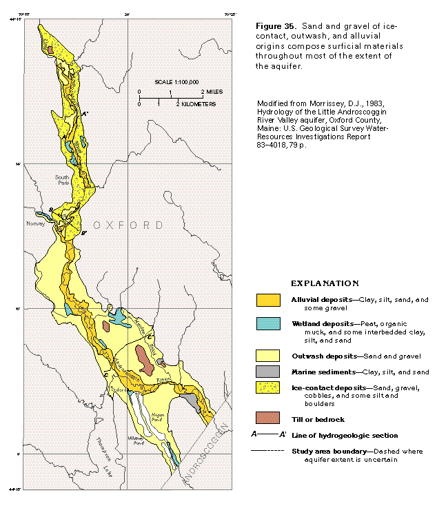
The Little Androscoggin River Valley aquifer is composed mostly of stratified sand and gravel deposited during the Wisconsinan stage of glaciation, which is the most recent advance of an ice sheet over this area. The character of the surficial deposits in the valley is shown in figure 35. The sediments that compose the aquifer are of three types: ice-contact sand and gravel with some cobbles and boulders, outwash sand that contains some gravel, and alluvial sand that contains some silt, clay, and gravel. The ice-contact and outwash deposits are of glacial origin, whereas the alluvial deposits that are along the stream channel and flood plain of the Little Androscoggin River are postglacial.
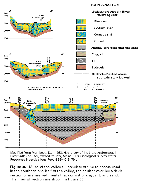
Ice-contact deposits, which are mostly located in the northern part of the valley (fig. 35), are primarily coarse, stratified sand and gravel that was deposited against the glacial ice by meltwater. As the ice continued to melt, the deposits collapsed, partially destroying their initial stratification. Ice-contact deposits also occur as a partly buried esker in the central and southern parts of the valley. These deposits are mostly medium to coarse sand but also contain silt, very fine sand, fine sand, and gravel (section A-A', fig. 36). Locally, they contain cobbles and boulders.
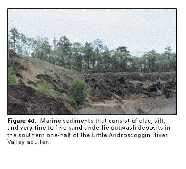
Outwash that consists of stratified sand with small amounts of gravel, was deposited by glacial meltwater throughout most of the southern half of the Little Androscoggin River Valley and in small areas in the northern half (fig. 35). Outwash deposits are mostly fine to medium sand with some gravel and are thickest near the southern limit of the main body of ice-contact deposits. Near Norway, the outwash deposits are mostly medium to fine sand (section B-B', fig. 36). In the southern part of the valley, the outwash deposits are mostly fine sand (section C-C', fig. 36) and overlie marine deposits of minimal permeability.
Marine deposition occurred in the southern part of the valley as the land surface was depressed by the immense weight of the glacial ice. The land surface was inundated by the ocean as the ice melted and the sea level rose, but the surface eventually rebounded to its present position after the ice receded. Marine deposits of clay, silt, and fine sand generally rest on bedrock, but, in a few places, till and ice-contact deposits underlie the marine clay and silt, as shown at the right side of section C-C' in figure 36. The esker shown in this figure was formed by a meltwater stream flowing either in a tunnel at the base of the ice or in a crack in the ice. The stream deposited coarse sand along its bed, and these coarse sediments were later partially covered in places by marine deposits. The esker is exposed at the land surface in several places and is mapped as ice-contact deposits in figure 35.
Alluvium underlies the flood plain and surrounds the channel of the Little Androscoggin River (fig. 35). The alluvium is fine to medium sand with some silt, clay, and gravel. It was largely formed from outwash and ice-contact material that was reworked by the river.
Till is unsorted and unstratified clay, silt, sand, gravel, and boulders that were deposited directly from the glacial ice. Till mantles the bedrock that is peripheral to the aquifer and is exposed on several low hills within the boundaries of the
aquifer (fig. 35).
Wetland deposits, which consist of peat and organic muck (fig. 35), accumulated in low-lying areas that are below the water table. The wetland deposits generally are only a few feet thick and commonly represent the infilling of a pond or small lake by silt and organic material.
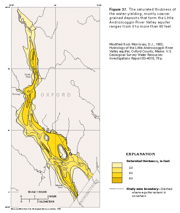
The combined saturated thickness of the water-yielding ice-contact, outwash, and alluvial deposits is greater in the northern part of the valley than in the southern part (fig. 37). For the most part, only coarse-grained deposits are mapped, but fine sands are included in the saturated thickness as mapped in the southern parts of the valley. Saturated thickness is greater than 40 feet throughout most of the northern half of the valley because of the greater thickness of coarse-grained ice-contact deposits.
As the ice retreated up the valley from Norway, ice-contact sand and gravel was deposited between the ice and the valley sides, and outwash was deposited in front of the ice by streams that were channeled down the valley. Although partially filled with sediments, the valley remained as a topographic low after the ice receded and formed a channel for the present-day stream that reworked sediments along its bed to produce the ribbon of alluvial material shown in figure 35.
HYDROLOGY
The Little Androscoggin River Valley aquifer is not hydraulically connected with valley-fill glacial aquifers in other valleys, and the aquifer does not extend past the drainage basin of the Little Androscoggin River. Thus, precipitation that falls on the Little Androscoggin River aquifer and the surrounding basin area is the source of all water in the basin. Long-term, average annual precipitation is about 43.2 inches of which 53 percent, or about 22.9 inches, is returned to the atmosphere by evaporation or is transpired by plants. The remaining 47 percent, or about 20.3 inches, leaves the basin as streamflow; some of this water runs off directly, and some is released more slowly from storage in lakes, marshes, or the aquifer.
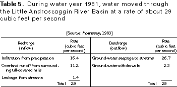
The largest volume of water stored in the basin is in the Little Androscoggin River Valley aquifer; water enters the aquifer as recharge primarily from precipitation that falls directly on the aquifer. During water year 1981, direct recharge to the 16-square-mile aquifer was estimated to be at an average annual rate of 16.4 cubic feet per second (table 5).
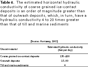
Additional recharge is contributed by overland runoff from the 23 square miles of till-covered hills within the basin that surrounds the aquifer. Although some water undoubtedly moves in the till and in the marine sediments that underlie the aquifer, the extremely low hydraulic conductivity of these materials (table 6) precludes any appreciable quantity of water entering the aquifer as underflow. Inflow from the upland areas is considered to be totally from overland flow. Recharge from overland runoff during water year 1981 was estimated to be at an average annual rate of 11.2 cubic feet per second (table 5).
A third source of recharge to the aquifer is from the infiltration of water from the Little Androscoggin River and its tributary streams when and where the water level in the streams is higher than the hydraulic head in the aquifer; for example,
this condition occurs in the vicinity of the South Paris well field where ground-water withdrawals have lowered the water table of the aquifer and induced recharge from the river. The contribution of water from the river to the aquifer during water
year 1981 was estimated to be at a rate of 1.4 cubic feet per second (table 5). These several sources of water contribute a total of about 29 cubic feet per second of water to the aquifer as recharge.
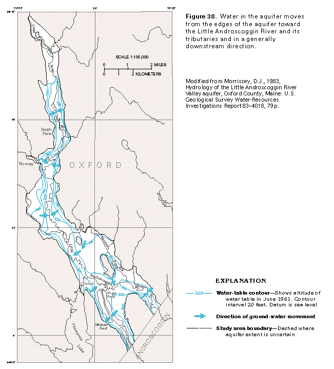
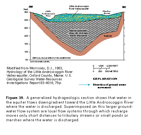
As recharge water enters the soil overlying the aquifer, it moves downward through an unsaturated zone to the top of the saturated zone, which is the water table and the top of the aquifer. A contour map of the water-table altitude (fig. 38) indicates that the water table slopes from the edges of the aquifer toward the Little Androscoggin River and from north to south in a downstream direction. Thus, water that enters the aquifer flows horizontally through the aquifer in response to
the hydraulic gradient toward the Little Androscoggin River (figs. 38, 39) where it is discharged and becomes part of the streamflow. Small local flow systems that discharge to tributary streams or marshes are superimposed on this larger system.
The rate of ground-water flow is dependent on the hydraulic gradient and the hydraulic conductivity of the aquifer material. Hydraulic-conductivity values listed in table 6 indicate that under an equal hydraulic gradient, the rate of flow is largest in ice-contact deposits, much less in outwash deposits, and minimal in till and marine deposits.
Ground-water seepage into the Little Androscoggin River and its tributaries is the principal method of discharge from the Little Androscoggin River Valley aquifer. The rate of this seepage was about 26.7 cubic feet per second during water year 1981 (table 5). The other method of discharge, which diverts water that normally would discharge to streams, is ground-water withdrawals from the aquifer for municipal and domestic water supply. Water was withdrawn during water year 1981 at a rate of 2.3 cubic feet per second. Most of the withdrawals were for municipal supply for the towns of South Paris, Norway, and Oxford.
Total discharge (outflow) from the Little Androscoggin River Valley aquifer was about 29 cubic feet per second during water year 1981, which was equal to aquifer recharge (inflow) (table 5). Thus, the aquifer is in equilibrium, with recharge equal to discharge, and the volume of water in storage remains constant.
The principal hydrologic effect of the marine sediments associated with valley-fill glacial aquifers in Segment 12 (fig. 40) is to form a barrier to ground-water flow. The fine-grained sediments retard the movement of water between the glacial deposits and bedrock.
Wells completed in the Little Androscoggin River Valley aquifer yield from 6 to 1,300 gallons per minute. Yields are largest for wells completed in the coarse-grained ice-contact deposits and least for wells completed in outwash material. The average yield of eight large-diameter municipal wells completed in the aquifer is 650 gallons per minute. Chances of obtaining large well yields are greater north of Norway because the coarse-grained ice-contact deposits are thicker and more extensive.
GROUND-WATER QUALITY
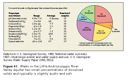
The water from the Little Androscoggin River Valley aquifer has small dissolved-solids concentrations (fig. 41) and generally is suitable for most uses. The water is a calcium sodium bicarbonate type, which is not typical of water in most valley-fill glacial aquifers. Large concentrations of iron and manganese in the water are present locally; these constituents are not a hazard to health and can be easily removed from
the water by treatment. The water typically is slightly acidic and soft.
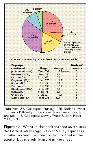
Water in the bedrock surrounding the Little Androscoggin River Valley aquifer is similarly a calcium sodium bicarbonate type (fig. 42) but has a higher ratio of sodium to chloride than does water from the aquifer. Minimal circulation of water in the bedrock, which results in the water being in contact with aquifer minerals for a long time, might account for the relatively large concentrations of sodium.
IRONDOGENESEE AQUIFER
The Irondogenesee aquifer is an example of a glacial-drift aquifer deposited by meltwater streams in a broad lowland partly inundated by large freshwater lakes. The broad lowland was inundated by the glacial lake that was the predecessor of Lake Ontario when it was at a high stage during the glacial period. Soils and the underlying parent material partly consist of clay and silt laid down as lake sediments. As the glacier melted, northward drainage was blocked by the retreating ice; thus, ponding of meltwater occurred in the area with accompanying deposition of fine-grained glacial-lake sediments.
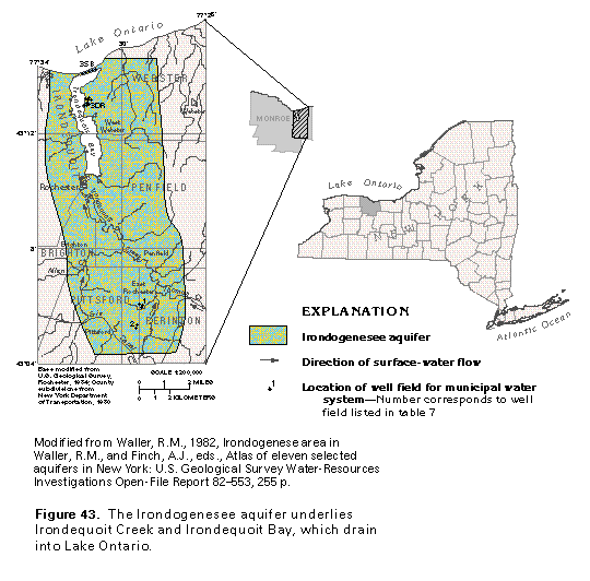
The Irondogenesee aquifer is in the Irondogenesee buried valley in eastern Monroe County, N.Y. (fig. 43), in the drainage basin of Irondequoit Creek. The valley is a deep, preglacial valley cut into bedrock by a stream that drained northward
into the ancestral Lake Ontario basin. The bedrock valley underlies the present Irondequoit Creek and Irondequoit Bay; drainage is northward into Lake Ontario. The city of Rochester is at the western edge of the area, and the village of Webster is about 2 miles east of the area. The villages of East Rochester, Pittsford, Penfield, and West Webster are within the area. The area is heavily urbanized and has an estimated population of 200,000.
Irondequoit Creek and Bay are the dominant geographic features. The creek, which drains about 150 square miles of rolling glaciated topography to the south, has incised as much as 200 feet into fine-grained sediments on the relatively flat lake plain from East Rochester north to the bay. Irondequoit Bay covers about 2.6 square miles and has a maximum reported depth of 75 feet. The bay connects with Lake Ontario through a narrow inlet that is shielded by a sandbar. Steep, wooded bluffs about 100 feet high border the bay and are underlain by glacial and proglacial-lake sediments. Extensive wetlands are present along the southern part of the bay and the downstream reaches of Irondequoit Creek.
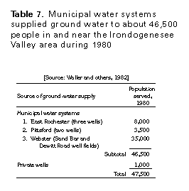
Water from the Irondogenesee aquifer supplies about 47,500 people, and about 11,500 of them are supplied by municipal water systems that serve the villages of East Rochester and Pittsford (table 7). The Sand Bar and Dewitt Road well fields (fig. 43) supply water to about 35,000 people in Webster. Private wells constructed for domestic use supply about 1,000 people. The remaining population is served by the Monroe County Water Authority, which gets water from Lake Ontario. Industrial ground-water use in the area is negligible; most industry is supplied from Lake Ontario. Some industries and towns have developed large-capacity wells but have not used them because of the ready access to lake water.
GEOLOGY
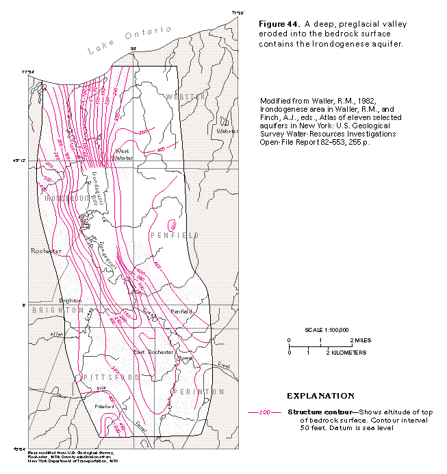
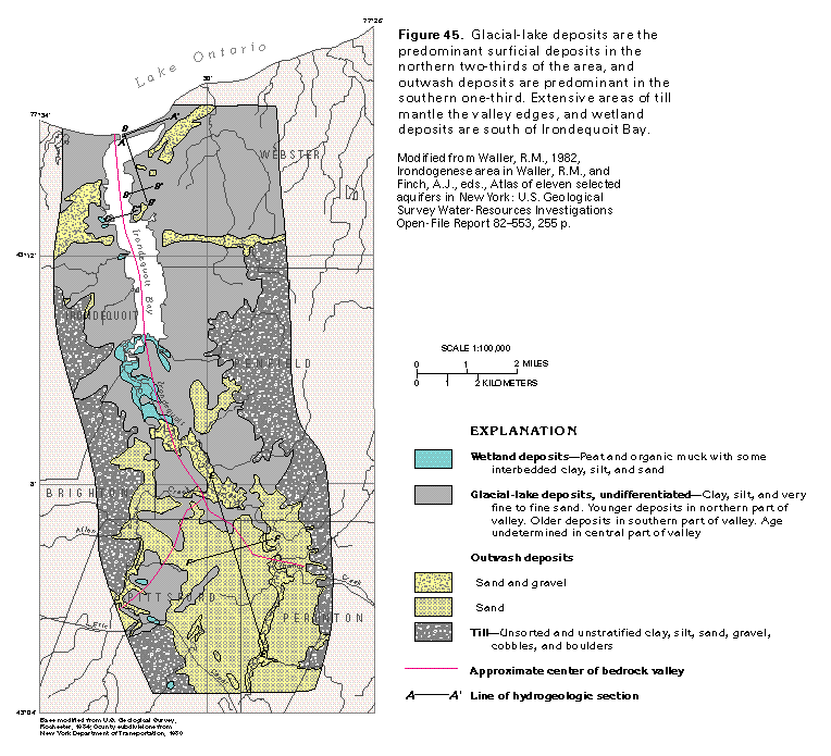
The Irondogenesee aquifer consists of glacial deposits in a deep, preglacial valley eroded into bedrock (fig. 44). The valley slopes and deepens northward toward Lake Ontario to a minimum altitude of about 100 feet below sea level, or about 600 feet below the maximum bedrock altitude of about 500 feet above sea level. Till on the periphery of the area (fig. 45) was deposited by glacial ice as it advanced over the area.
However, the surficial deposits shown in figure 45 are chiefly lacustrine clay, silt, and sand in the northern two-thirds of the area. These glacial-lake deposits are commonly present in low-lying areas throughout the central part of the valley. The glacial-lake deposits represent deposition when the area was occupied by either a high stage of ancestral Lake Ontario or by an ephemeral lake trapped by the glacial ice. Outwash deposits of sand or sand and gravel are present on the terraces in the southern one-third of the basin and represent a final melting phase of the most recent glaciation. The sand and gravel were deposited by sediment-laden meltwater streams draining off the tongue of ice that filled the buried valley.
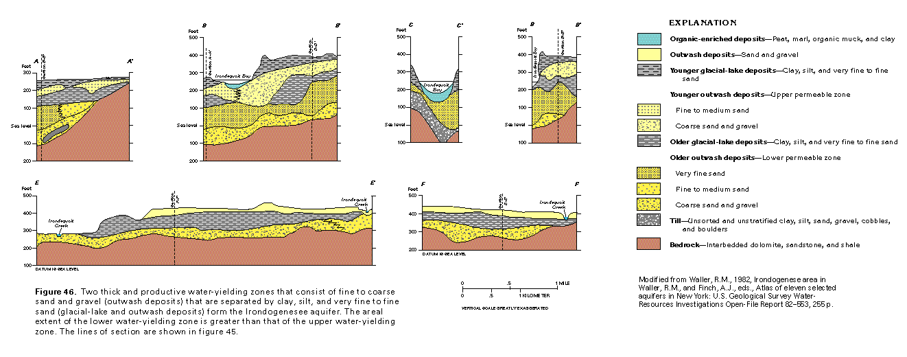
The relation of the glacial sediments in the subsurface is shown by the hydrogeologic sections in figure 46. These sections show that in much of the area, a thick, permeable sand and gravel deposit overlies bedrock. This sand and gravel may represent a preglacial alluvial deposit, but it more likely is outwash deposited during the melting of an early glacial stage. The sand and gravel is overlain by fine sand in the northern part of the area (sections A-A' through C-C'). The fine sand is in turn overlain by clay, silt, and very fine sand deposited in a proglacial lake or part of ancestral Lake Ontario. A second deposit of permeable sand and gravel overlies the glacial-lake beds in the northern part of the area, whereas fine sand is atop the lacustrine beds to the south (sections D-D', E-E'). The uppermost deposits in the northern part of the area are a second layer of glacial-lake deposits.
AQUIFER THICKNESS AND EXTENT
The Irondogenesee aquifer consists of two thick, productive sand and gravel layers and lenses that are separated in most places by less permeable glacial-lake beds. Two well fields, the Dewitt Road and Sand Bar fields that supply the village of Webster, have been developed in the northern part of the aquifer. Wells in the Sand Bar field obtain water from the upper and lower permeable zones of the aquifer (sections A-A', B-B', fig. 46). Wells in the Dewitt Road field reportedly produce water from only the lower permeable zone (sections C-C', D-D', fig. 46), which is hydraulically connected to the lower permeable zone north of the well field (section B-B',
fig. 46). The lower permeable zone of the aquifer is from 60 to 85 feet thick and might extend as far west as the center of the Irondogenesee Valley; the zone extends northward under Lake Ontario. In the southern part of the area, the aquifer con-sists only of the lower permeable zone (sections E-E', F-F', fig. 46). Here, the lower permeable zone consists of sand and gravel, which is about 80 feet thick (section F-F', fig. 46) and extends laterally at least 3 miles. Well fields that supply East Rochester and Pittsford obtain water from this zone. The northern extent of this sand and gravel is unknown, but it may connect with the lower permeable zone of the aquifer at the Dewitt Road well field.
HYDROLOGY
Water in the upper permeable zone is under water-table (unconfined) conditions where the sand and gravel of the zone are exposed at the land surface (fig. 45) or where the overlying glacial-lake deposits are extremely thin, such as in the vicinity of the Sand Bar well field (section A-A', fig. 46). The water is under artesian (confined) conditions where the upper permeable zone is covered by thick glacial-lake deposits. Recharge to the upper permeable zone primarily is by infiltration of precipitation into the sand and gravel where it is exposed at the land surface. Water in the upper permeable zone moves toward natural discharge areas along the shores of Irondequoit Bay and Lake Ontario. When wells completed in the upper permeable zone at the Sand Bar well field are pumped, they intercept some of the water moving toward natural discharge areas, increasing sustained well yields. Pumping of these wells also probably causes some water to move from the bay and the lake into the upper permeable zone, further increasing sustained well yields.
Water in the lower permeable zone is under artesian conditions throughout most of the area, especially in the northern part. The water is under unconfined conditions where the sand and gravel of the lower permeable zone are exposed at the land surface north of East Rochester (fig. 45; left side of section E-E', fig. 46).
In the southern part of the area, most recharge to the lower permeable zone probably is by leakage through the beds of streams, such as Irondequoit Creek, that have eroded channels into the zone in their upstream reaches. Fractures in the underlying bedrock also contribute some recharge to the lower permeable zone. Water in the lower permeable zone generally moves toward Iron-dequoit Creek and downgradient to the north. Most discharge from the lower permeable zone is either to Irondequoit Creek, especially in its middle reach north of East Rochester (left side of section E-E', fig. 46), or by wells in the East Rochester, Pittsford, and Dewitt Road well fields (fig. 43). Some water might continue to move downgradient to the north to "recharge" the lower permeable zone in the northern part of the area if the lower permeable zone is continuous through the central part of the area.
In the northern part of the area, possible sources of recharge to the lower permeable zone are underflow from the south, inflow from fractured bedrock, and downward percolation of water from the upper permeable zone through the leaky confining unit between the two zones. The downward percolation of water from the upper permeable zone, at least in the vicinity of the Sand Bar and the Dewitt Road well fields, appears to be negligible because withdrawals from wells completed in the lower permeable zone at these well fields have had no effect on water levels in the upper permeable zone. The natural hydraulic gradient in the lower permeable zone is to the north toward Lake Ontario. Withdrawals by wells, which is the principal form of discharge from the lower permeable zone, at the Sand Bar and Dewitt Road well fields, however, have disrupted the natural hydraulic gradient. Withdrawals at the two well fields have lowered water levels about 70 feet near the well fields and reversed the natural hydraulic gradient. The wells are capturing water that formerly discharged into Lake Ontario, thus increasing sustained well yields. The reversal in hydraulic gradient also has caused water from Lake Ontario to flow into the lower permeable zone, further increasing well yields.
Yields of wells completed in the Irondogenesee aquifer generally are several hundred gallons per minute. Wells in the Sand Bar well field can yield 2.8 million gallons per day from the upper permeable zone and as much as 10 million gallons per day from the lower permeable zone. Withdrawals from the Dewitt Road well field are as much as 13 million gallons per day. The potential volume of water available from the southern well fields is unknown, but withdrawals of 0.4 million gallons per day from only two wells caused little drawdown; this indicates that the fields can produce at least a few million gallons per day.
GROUND-WATER QUALITY
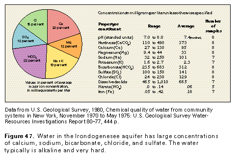
Water in the Irondogenesee aquifer is a mixed-ion type and has large dissolved-solids concentrations, as indicated by data for eight representative chemical analyses shown in figure 47. The water typically is alkaline and very hard. As expected, calcium concentrations are large, because of carbonate-rock fragments in the aquifer. The large calcium concentrations result in increased dissolved-solids concentrations, alkalinity, and hardness.
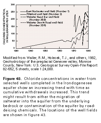
Chloride is a problem in water from some wells, as indicated by the large average concentration and the upper range of concentrations (fig. 47). Chloride concentrations appear to be increasing in water from several municipal wells with time (fig. 48) as cumulative withdrawals increased. Because these wells are completed in the aquifer just above the bedrock surface, saltwater from the bedrock might be migrating toward the pumping wells. These increased chloride concentrations also might be an indication of contamination of the aquifer by road-deicing chemicals.
Although concentrations of many constituents in water from the Irondogenesee aquifer are large compared to concentrations in water from other valley-fill glacial aquifers, the water from the Irondogenesee aquifer generally is suitable for most uses. Locally, the water contains objectionable concentrations of manganese and iron, or is excessively hard; however, the water is easily treated.
FRESH GROUND-WATER WITHDRAWALS
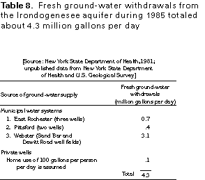
Fresh ground-water withdrawals from the Irondogenesee aquifer totaled about 4.3 million gallons per day during 1985 (fig. 49). Nearly all the water was withdrawn for public supply by three municipalities (table 8). Only about 2 percent of the water, or 0.1 million gallons per day, was withdrawn for domestic supply.