GROUND WATER ATLAS of the UNITED STATES
Alaska, Hawaii, Puerto Rico and the U. S. Virgin Islands
HA 730-N
Puerto Rico and the U. S. Virgin Islands Alluvial valley aquifers
There are two different files for each illustration
- A 72 ppi GIF file, suitable for screen viewing is accessed
through the thumbnail image.
- An eps file, suitable for downloading to be printed or edited
is accessed through the "eps file" link. Most files
are Adobe Illustrator 6.0, exceptions are noted. These files
have been compressed with GNU's gzip utility. If your web browser
defaults to a screen display of the file, turn on the "Load
to local disk" option before downloading. Download and process
these eps files as ascii, not binary.
Hydrology
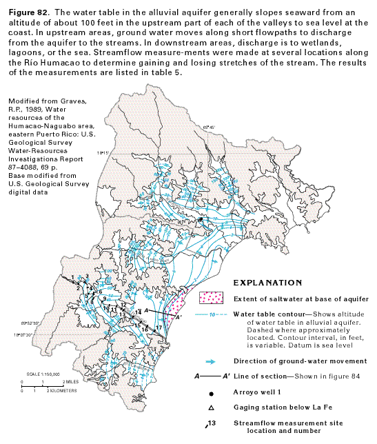
Figure 82 Map showing water table contours and direction
of ground-water movement in the alluvial valley aquifer in Puerto
Rico (44K)
 editable eps file N082.eps.gz
(159K compressed)
editable eps file N082.eps.gz
(159K compressed)
Table 5 Table showing streamflow measurements
in the Rio Humacao (44K)
 editable eps file Ntab05.eps.gz
(376K compressed)
editable eps file Ntab05.eps.gz
(376K compressed)
Figure 83 Graph showing altitude of river
stage and water table in adjacent well near Rio Blanco (17K)
 editable eps file N083.eps.gz
(15K compressed)
editable eps file N083.eps.gz
(15K compressed)
Figure 84 Diagram showing direction of ground-water
movement in the freshwater-saltwater interface in the Rio Humacao
Valley (35K)
 editable eps file N084.eps.gz
(36K compressed)
editable eps file N084.eps.gz
(36K compressed)
 editable eps file N082.eps.gz
(159K compressed)
editable eps file N082.eps.gz
(159K compressed) 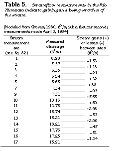 editable eps file Ntab05.eps.gz
(376K compressed)
editable eps file Ntab05.eps.gz
(376K compressed) 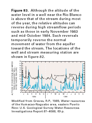 editable eps file N083.eps.gz
(15K compressed)
editable eps file N083.eps.gz
(15K compressed) 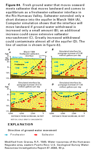 editable eps file N084.eps.gz
(36K compressed)
editable eps file N084.eps.gz
(36K compressed)