INTRODUCTION
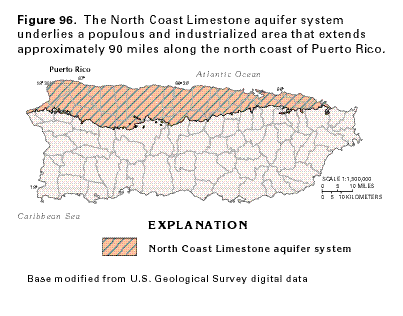
The North Coast Limestone aquifer system in Puerto Rico is one of the largest and most productive sources of ground water on Puerto Rico and the Virgin Islands. The aquifer system underlies a populous and industrialized area that extends approximately 90 miles along the north coast of Puerto Rico (fig. 96) and encompasses an area of nearly 700 square miles. The aquifer system consists of two limestone aquifers separated by an intervening confining unit. About 66 million gallons per day was withdrawn from the two limestone aquifers during 1985 for public-supply, industrial, agricultural, and domestic uses.
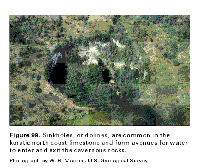
The limestones that compose the aquifer system are undeformed and relatively flat-lying with a dip of less than 5 degrees to the north. They range in altitude from about 1,300 feet above sea level to the south, where they overlie volcanic rocks, to below sea level at the north coast, where they extend under the Atlantic Ocean. All of the limestone formations, where they crop out at the land surface, have been subject to intense dissolution which has developed widespread karst topography (fig. 97). The rocks exhibit such unusual karst features as cone-shaped hills called mogotes (fig. 98), cockpit karst, and zanjón-type karst, which is characterized by parallel solutional trenches that range in width from a few inches to tens of feet and from 1 to 12 feet deep. Sinkholes, or dolines, similar to the one shown in figure 99 are extremely common and form avenues through which water can rapidly and directly enter and exit the cavernous limestones.
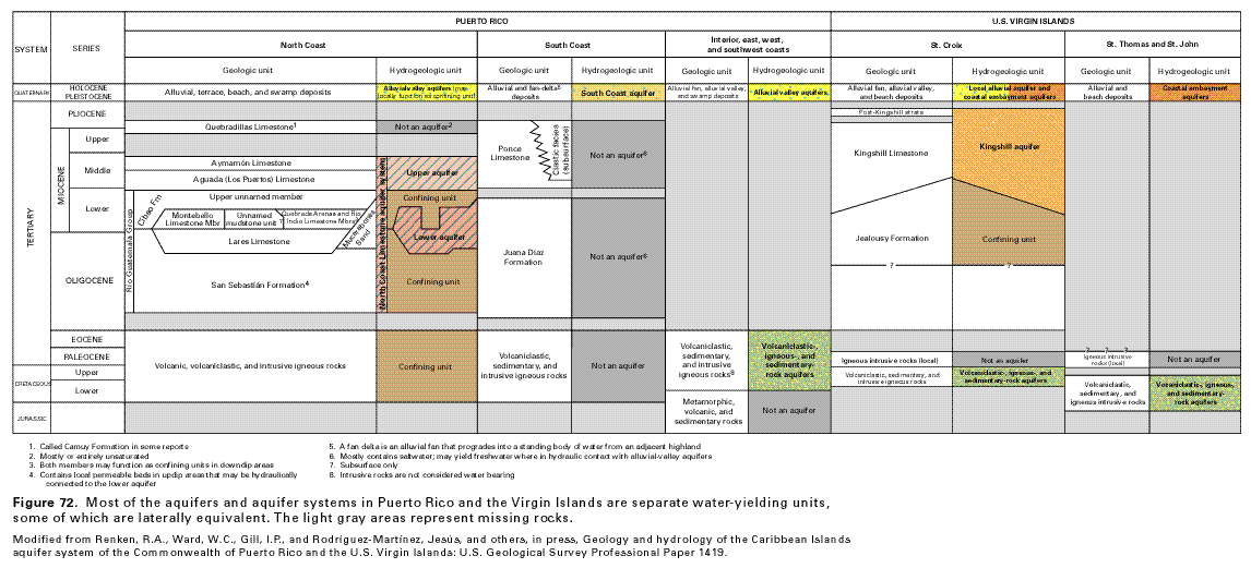
HYDROGEOLOGIC UNITS
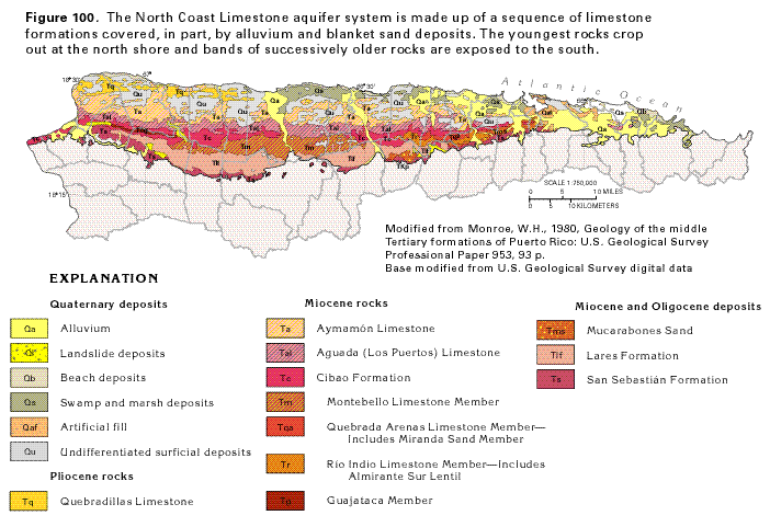
The North Coast Limestone aquifer system consists of a thick sequence
of carbonate rocks of Miocene to Oligocene age that formed as
platform deposits on the south flank of a broad depositional basin
that extends from Puerto Rico about 100 miles northward to the
southern slope of the Puerto Rico Trench. The aquifer system consists
mostly of limestone; however, not all strata yield water. Maximum
known onshore thickness of the limestones is about 5,600 feet,
but their maximum estimated offshore thickness is 11,500 feet.
The outcrop extent of the principal geologic units that compose
the aquifer system is shown in figure 100.
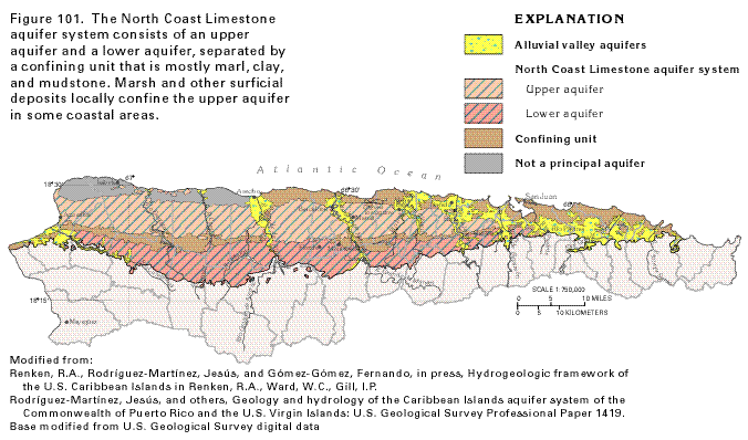
These numerous geologic units have been combined into an upper
and a lower aquifer, separated by a confining unit (fig.
101). The vertical sequence and hydrogeologic grouping of
the rock units are described in figure
72.
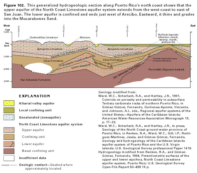
Rocks of the aquifer system overlie volcanic rocks of Eocene to Cretaceous age that have been intensely faulted, folded, and intruded by multiple plutons. The lowermost geologic unit of the aquifer system is the San Sebastián Formation (fig. 102) that unconformably overlies volcanic, volcani-clastic, and intrusive igneous rocks. The San Sebastián crops out in two discontinuous bands of clayey, silty conglomerate and feldspathic sandstone along the southwestern and southeastern edges of the North Coast Limestone aquifer system. It extends into the subsurface where it is more laterally extensive but grades into glauconitic mudstone and marl. The San Sebastián meets the Mucarabones Sand on the east (fig. 102) but its exact relation with that unit is unknown. The San Sebastián ranges in thickness from a featheredge where it crops out to about 1,000 feet in the deep subsurface. It yields small quantities of water in outcrop areas but is poorly transmissive and functions mostly as a confining unit, especially in downdip areas.
The Lares Limestone is predominantly a thick-bedded, fine- to medium-grained fossiliferous limestone that conformably overlies the San Sebastián Formation (figs. 72, 102). The Lares contains abundant reefal limestone but no biohermal masses. It crops out in a nearly continuous band that extends eastward from Aguádilla on the west coast to the Río de la Plata where it grades laterally eastward into the Mucarabones Sand (fig. 102). In the subsurface, to the west of Arecibo, the upper part of the Lares is similar to carbonate rocks of the Cibao Formation. Farther west, time-equivalent rocks grade to a lithology typical of the upper part of the San Sebastián. On the basis of lithology, the Lares west of Arecibo probably does not constitute an aquifer. The Lares ranges from about 150 to 650 feet in thickness at outcrop to about 950 feet downdip near Arecibo.
The Cibao Formation is divided into a number of members (fig. 72) that represent a variety of depositional environments. The Río Indio Limestone Member and the overlying Quebrada Arenas Limestone Member, located approximately between the Río Cibuco and the Río de la Plata (fig. 102), are marginal marine and biostromal carbonates that uncon-formably overlie the Lares Limestone. The Montebello Limestone Member, which is an extensive carbonate buildup sequence, is present to the west between the Río Camuy and the Río Grande de Manatí and also overlies the Lares (fig. 102). A poorly transmissive mudstone unit that has been identified only in the subsurface in the vicinity of Manatí is the equivalent of the Río Indio and Montebello Limestone Members. It lies between and separates these two carbonate units. The uppermost and most extensive part of the Cibao Formation is the upper unnamed member, a carbonaceous mudstone and limestone sequence that overlies the other members to the east and composes the entire Cibao to the west (fig 103, 104).
The Mucarabones Sand consists predominantly of cross-bedded, fine to medium quartz sand that grades upward into sandy limestone near the top. The sand is moderately to poorly sorted and a clay matrix in the lowermost part is replaced by a calcite cement higher in the section. Local conglomerates in the formation contain volcanic-rock cobbles up to 1.5 inches in diameter. The formation overlies, in part, the San Sebastián Formation and, in part, volcanic rocks (fig. 102). The Mucarabones Sand ranges in thickness from about 33 feet at its western extent (near Ciales) to about 400 feet near Bayamón. The Mucarabones is a stratigraphic equivalent of both the Lares Limestone and the Cibao Formation (fig. 72).
The Aguada (Los Puertos) Limestone conformably overlies the Cibao Formation and the Mucarabones Sand and crops out in a narrow belt that extends from the west coast to east of the Río de la Plata (fig. 100). The Aguada consists of dolomitic limestone and massive recrystallized limestone with some quartz sand. East of the Río de la Plata, the formation grades laterally into a chalky limestone and calcareous clay that is indistinguishable from the unnamed upper member of the Cibao Formation. The Aguada (Los Puertos) ranges in thickness from about 200 to 380 feet.
The Aymamón Limestone overlies the Aguada (Los Puertos) Limestone (fig. 72) and is described in outcrop as a thick to massively bedded, nearly pure limestone that becomes dolomitic near the coast. The Aymamón Limestone crops out in a broad belt from the west coast eastward to Toa Baja (fig. 100). In the subsurface, the Aymamón is as much as 1,000 feet in thickness in northwestern Puerto Rico. East of Toa Baja, dissolution has reduced the thickness and areal extent of the formation, and it is not hydrologically significant. The Ay-mamón is covered in this area by alluvium and blanket sand deposits.
The Quebradillas Limestone unconformably overlies the Aymamón Limestone (figs. 72, 102) and crops out as a discontinuous belt along the north coast from Isabela eastward to Dorado (fig. 101). East of the Río Grande de Manatí, the Quebradillas is present only as outliers on hills of Aymamón Limestone. The maximum thickness of the Quebradillas is about 300 feet, and it is predominantly a chalky, deep-water limestone but contains considerable quartz sand and is iron-rich, especially in the lower part. The Quebradillas Limestone is largely unsaturated in northwestern Puerto Rico and, therefore, generally yields no water.
To the east of Manatí, the limestones are directly overlain by as much as 100 feet of unconsolidated deposits consisting of alluvial, terrace, beach, and swamp deposits collectively referred to as blanket sands in some reports. The principal river valleys drain northward; they have been incised into the limestones and are filled with as much as 300 feet of river alluvium. The unconsolidated deposits may be partially saturated and are in hydraulic connection with the limestones.
AQUIFERS AND CONFINING UNITS
The North Coast Limestone aquifer system consists of two aquifers
separated by a confining unit. The upper aquifer contains water
mostly under unconfined conditions and consists primarily of the
Aymamón and Aguada (Los Puertos) Limestones (fig.
103). The aquifer extends from Aguádilla on the west
coast to the vicinity of San Juan (fig.
101). The extent of the aquifer east of San Juan is unknown.
The valleys of principal rivers that have been incised into the
Aymamón and Aguada Limestones are filled with partially
saturated alluvium that is in hydraulic connection both with the
rivers and the upper aquifer. Similarly, where they are saturated,
the Quebradillas Limestone and unconsolidated deposits that overlie
the upper aquifer near the coast are in hydraulic connection with
the aquifer.
The confining unit in the middle of the aquifer system is complex. It consists of the upper unnamed member of the Cibao Formation, a mudstone unit that appears to be present only in the subsurface near Manatí, and the Quebrada Arenas and Río Indio Limestone Members of the Cibao Formation in downdip coastal areas (fig. 72). West of Arecibo, the confining unit is very thick. Water-bearing rocks of the Montebello Limestone Member and Lares Limestone grade to a Cibao lithology in northwestern coastal areas and are considered part of the middle confining unit.
The lower aquifer is formed primarily of the Montebello Limestone Member of the Cibao Formation and the Lares Limestone (figs. 102, 103). However, the aquifer includes the Mucarabones Sand and water-yielding parts of the Río Indio and Quebrada Arenas Limestone Members to the east, and the San Sebastián Formation in areas of outcrop. Where the formations that compose the lower aquifer crop out at the southern part of the limestone belt, water in the aquifer is under water-table, or unconfined, conditions. However, as the aquifer extends northward under the Cibao Formation, the water is under confined conditions. In the subsurface to the west of Arecibo, the Lares Limestone and Montebello Limestone take on the character of the upper unnamed member of the Cibao Formation and are of such low transmissivity that they do not constitute an aquifer.
HYDRAULIC PROPERTIES
The upper 100 to 300 feet of the Aymamón Limestone is a
dense, recrystallized, and chalky limestone in which extensive
cavernous porosity has developed. The openings are the result
of solution enlargement of secondary openings in the rock, as
well as solution of aragonite fossil shells and dolomite, by circulating,
slightly acidic ground water and might be partly related to sea
level changes with attendant shifting of the saltwater-freshwater
interface. In the lower part of the Aymam-ón Limestone
and in the Aguada (Los Puertos) Limestone, porosity is extremely
variable and is largely controlled by the presence of dolomite,
dissolution of aragonitic fossils, and solution-enhanced fractures.
Porosity that results solely from dissolution of fossils is as
much as 10 to 15 percent; where dolomitization has further increased
porosity, it might be as much as 25 percent.
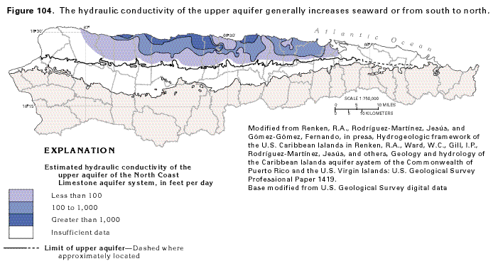
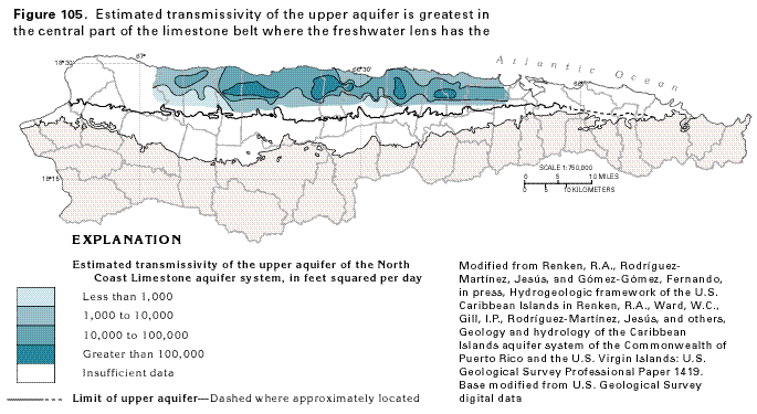
The hydraulic conductivity of the upper aquifer [the Aymamón and Aguada (Los Puertos) Limestones] ranges from less than 100 to greater than 1,000 feet per day; the greatest values are near the ocean (fig. 104). The transmissivity of the upper aquifer (the hydraulic conductivity of the aquifer times the saturated thickness) ranges from about 1,000 to about 100,000 feet squared per day; the greatest values are located in the central part of the aquifer where the freshwater lens has the greatest thickness (fig. 105).
In the lower aquifer, porosity and permeability vary considerably as a result of vertical and lateral changes in rock type. The rocks have some primary intergranular porosity, but most of the porosity is secondary and results from dissolution of fossils and from dolomitization. Fracturing does not appear to substantially enhance permeability in the lower aquifer. Most of the rocks that compose the lower aquifer typically have a porosity of 10 to 15 percent but locally porosity is as high as 20 to 25 percent. Individual beds with a porosity of greater than 10 percent are in the Montebello Limestone Member of the Cibao Formation and the Lares Limestone east of Arecibo.
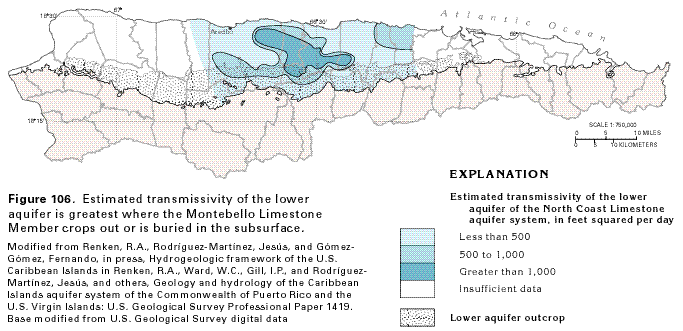
The transmissivity of the lower aquifer, shown in figure 106, ranges from less than 50 to greater than 1,000 feet squared per day. Transmissivity may be as high as 10,000 feet squared per day in local subsurface areas and locally as high as 14,000 feet squared per day where the aquifer crops out. In general, transmissivity of the lower aquifer is greatest where the Montebello Limestone Member is present.
GROUND-WATER FLOW
Ground-water flow in the North Coast Limestone aquifer system
is not well documented because of the difficulties in accurately
defining flow in a karst environment; the lack of an adequate
distribution of observation wells, as well as the lack of wells
in the lower aquifer; and the lateral variability and complexity
of the geology, especially in the lower aquifer. However, a generalized
concept of ground-water flow was determined from available geologic
and hydrologic information and well data.
Recharge to the upper aquifer is primarily from the part of the precipitation that infiltrates to the water table in the Aymamón and Aguada (Los Puertos) Limestones. The precipitation either enters the aquifer directly or percolates downward through overlying alluvial and blanket sands, the Québradillas Limestone, or both. Recharge also occurs as leakage from streams in areas where streambeds are at a higher altitude than the water table, and some water from the lower aquifer might leak upward and enter the upper aquifer.
The San Sabastian Formation, the Lares Limestone, Montebello Limestone, the Río Indio Limestone, and the Quebrada Arenas Members of the Cibao Formation, the Mucarabones Sand that compose the lower aquifer, are unconfined in their outcrop areas. Where they are exposed at the land surface, they are recharged from precipitation and possibly from streams.
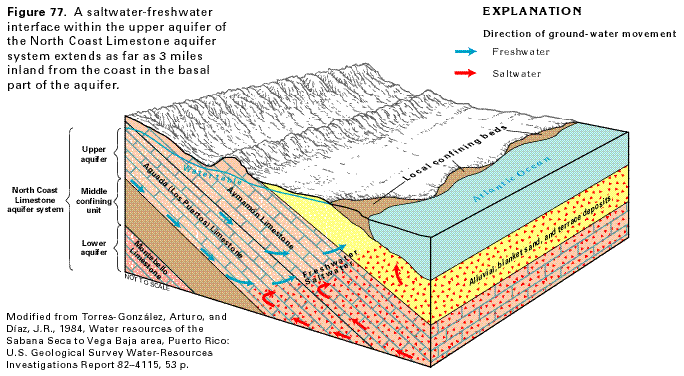
A freshwater-saltwater interface is present at the coast in the upper part of the upper aquifer (fig. 77). Near the base of the aquifer, the interface extends from 1 to 3 miles inland; the conditions shown in figure 77 are representative of the Vega Baja area. The interface is at sea level near the coast and becomes progressively deeper inland. Freshwater is present at the coast in the lower aquifer because the higher hydraulic head in the lower aquifer prevents saltwater from moving into the aquifer. A freshwater-saltwater interface probably is present in the lower aquifer an unknown distance seaward from the coast.
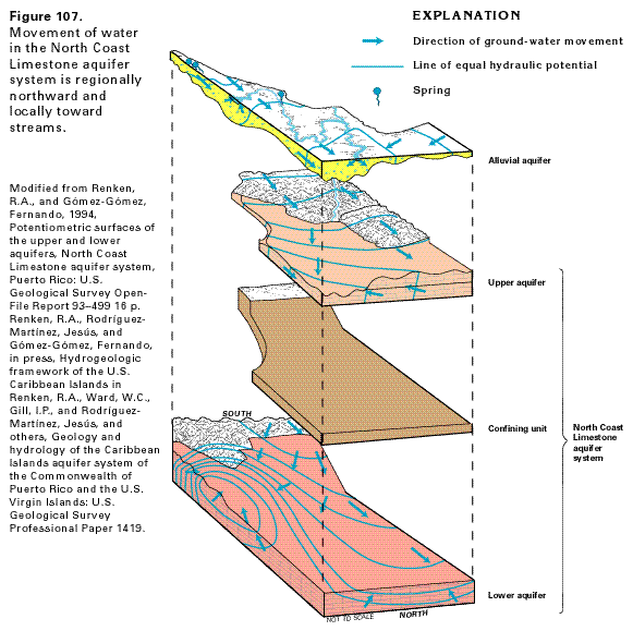
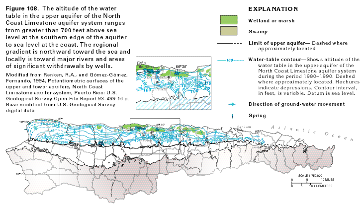
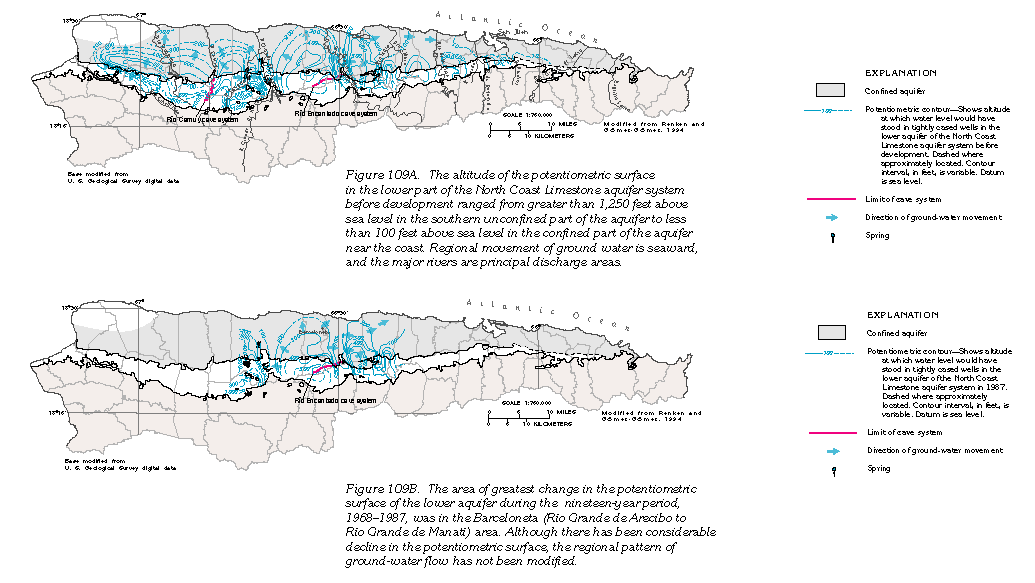
Regional ground-water flow in each of the aquifers follows the slope of the land surface and is northward and toward the Atlantic Ocean (figs. 107, 108, 109A). Water in the upper aquifer discharges primarily to springs, to wetlands and swamps in coastal areas, and to streams (fig. 108). Much of the water that enters the lower aquifer's shallow flow system discharges to the principal north-flowing rivers and some large springs contained within these river valleys (figs. 107, 109A, B). Some water enters deeper parts of the flow system and discharges by diffuse upward leakage through the confining unit to the upper aquifer. Both the upper and lower aquifers discharge by withdrawals from wells.
A water-table map of the upper aquifer from San Juan to the west coast is shown in figure 108. The water table slopes northward from an altitude of greater than 700 feet above sea level on the southern boundary of the aquifer to sea level at the coast. Thus, ground-water movement generally is northward toward the ocean and locally toward the major rivers. A large potentiometric depression which extends over a 14 square mile area northwest of Barceloneta is caused by agricultural dewatering in the Caño Tiburones area. Caño Tiburones is the site of a former shallow brackish water coastal lagoon that accumulated freshwater from adjacent springs and rivers. Drainage of the area caused soil shrinkage and land subsidence and gradually lowered the water table to sea level. Gravity drainage became less effective and a drainage system of canals, tidal gates and coastal pump stations was installed to water levels below sea level. The potentiometric depression has caused a reversal in gradient of the water table, and has caused intrusion of sea water into Caño Tiburones. Smaller cones of depression resulting from withdrawals between Barceloneta and Vega Baja have likewise caused a reversal in the regional gradient.
Little is known about ground-water flow in the area from the west coast to Isabella. Much of the area is a limestone plateau with an altitude typically greater than 300 feet above sea level. It is bordered on the north and west by seaward-facing cliffs and, therefore, has a deep water table. Chemical analysis of water from a well drilled near Isabella indicates that the upper aquifer in this area contains saltwater beneath a lens of freshwater that is only about 25 feet thick. The extent of this saltwater is unknown. Ground water contained in the lower aquifer in the extreme western part of the area probably moves toward the Río Culebrinas and the ocean.
Water in the lower aquifer flows from the outcrop area of the Montebello Limestone Member of the Cibao Formation and the Lares Limestone, where it is under water-table conditions, northward and becomes confined by the upper, unnamed member of the Cibao Formation. The predevelopment potentiometric surface of the lower limestone aquifer from the west coast to San Juan is shown in figure 109A. The maximum altitude of the potentiometric surface in the unconfined area on the south exceeds 1,250 feet above mean sea level and the gradient generally is northward toward the coast. Thus, regional ground-water movement is seaward, but deeply entrenched river valleys such as the Río Grande de Arecibo and the Río Grande de Manatí are major discharge areas. Other rivers, such as the Río Camuy, also appear to receive some discharge from the lower limestone aquifer. Ground-water movement in the outcrop area on the west end of the aquifer appears to be southward to the Río Culebrinas. Ground-water movement in the area of Vega Baja and eastward generally appears to be eastward and locally to the Río Hondo and other streams in that area.
Large cave systems represent major ground-water drains in some areas where the lower aquifer crops out. This is evident in the Río Camuy cave system and the Río Encantado cave system where potentiometric contours show a pattern indicative of ground-water discharge (fig. 109A).
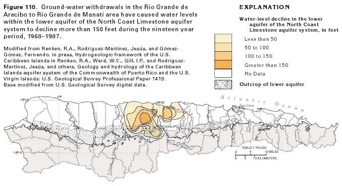
Ground-water development within confined parts of the lower aquifer are largely restricted to an area that extends eastward from Río Grande de Arecibo to Laguna Tortuguero and southward to Florida and Montebello. Ground-water withdrawals from the lower aquifer for industrial and municipal purposes have caused a decline in the potentiometric surface of the lower aquifer (fig. 110). Well withdrawals in the Barceloneta area have drawn down water levels more than 150 feet during the period 1968 to 1987. However, the regional pattern ground-water flow in this area has not been greatly altered (fig. 109B).
In the eastern end of the island between the Río de la Plata and the Río Espíritu Santo, the aquifer system is covered by unconsolidated blanket sands and alluvial deposits that range in thickness from about 100 feet in upland areas to about 300 feet in stream valleys. Ground water is under water-table conditions in the sands and alluvial deposits and the underlying upper aquifer of the limestone aquifer system. The lower aquifer is represented by the Mucarabones Sand and contains freshwater under confined conditions from the Río de Bayamón to the Río Piedras. In much of this area, the Aymamón Limestone of the upper aquifer contains saltwater because of its proximity to the sea. Ground-water discharge in this area is predominantly to streams that drain to the ocean; however, there also may be direct discharge from the aquifers to the ocean.
The area from the Río de la Plata to the Río Espíritu Santo has a long history of water-resources development. Large ground-water withdrawals, wetland drainage projects, dredging of San Juan Bay, channelization of the Río Hondo and the Río de Bayamón, and other developments have caused saltwater intrusion from the ocean. Although there is some freshwater in unconsolidated deposits, saltwater is present at depths of only about 100 feet; thus, ground-water development is now limited to small domestic wells. Generally, only small volumes of ground water are withdrawn in this area, and surface water is the principal source of supply. However, some wells are used as emergency sources of water for the city of San Juan.
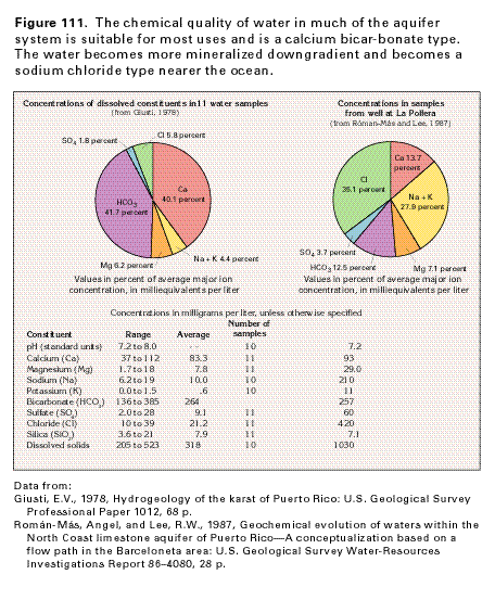
GROUND-WATER QUALITY
The natural chemical quality of water in inland areas of each
of the aquifers of the North Coast Limestone aquifer system is
suitable for most uses. The dominant chemical process that has
affected the water in the aquifer is dissolution of the limestone.
As a result, calcium and bicarbonate ions dominate the dissolved
constituents in the water, and the water is slightly alkaline
(fig. 111). Average concentrations
of chloride, sulfate, sodium, and potassium total only about 12
percent of the dissolved ions. Average magnesium concentration
is greater in water from the lower aquifer than in water from
the upper aquifer but generally is small (about 6 percent), which
reflects the small amount of dolomite in the rocks.
The chemical quality of the water changes as it moves from aquifer outcrop areas downgradient toward the Atlantic Ocean. Concentrations of dissolved magnesium, dissolved sulfate, dissolved solids, and pH of the water generally increase oceanward. Within the upper aquifer, continuous recharge maintains the dissolution of carbonate minerals, and calcium and bicarbonate remain the dominant ions in much of the aquifer.
Near the coast, saltwater underlies and mixes with freshwater in the upper aquifer. This mixing causes large concentrations of dissolved sodium, potassium, and chloride in the ground water. Sea spray carried inland by wind enters the aquifer, which further contributes to the increase of sodium and chloride ions. Mixing of saltwater and freshwater is the dominant chemical process in the upper aquifer near the coast, and, in some places, for a considerable distance inland. For example, water from a well completed in the upper aquifer at La Pollera (fig. 108), almost 5 miles from the coast, contains large concentrations of sodium and chloride (fig. 111). The lower aquifer, where it is present at the coast, is protected from the downward leakage of saltwater by the overlying confining unit. The hydraulic gradient in this aquifer also is upward where the aquifer is confined. The lower aquifer probably contains freshwater throughout its entire inland extent.
Excessive ground-water withdrawals and chemical spills on the land surface locally have caused changes in the quality of the water in the limestone aquifers. Various organic chemicals used as industrial solvents, degreasers, dry-cleaning agents, and other uses have been detected in water from wells. Many of these organic contaminants have found their way into the limestone aquifers and locally are present in concentrations as large as 770 micrograms per liter. The contaminants have forced the abandonment of 13 public water-supply wells; the wells had a combined production of 5.5 million gallons per day. In the Río de la Plata to the Río Espíritu Santo area, excessive ground-water withdrawals and dewatering accompanying urbanization have caused the migration of saltwater from the ocean into the limestone aquifers. As a result, continuously operated public-supply wells exist only near the Río de la Plata; these wells have a sustained yield of less than 4 million gallons per day.
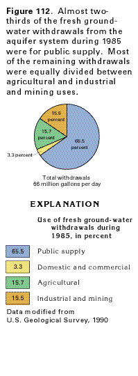
FRESH GROUND-WATER WITHDRAWALS
Total fresh ground-water withdrawals from the North Coast Limestone
aquifer system during 1985 were about 66 million gallons per day
(fig. 112). Withdrawals for public
supply accounted for the majority of the water pumped from the
aquifer system; 65.5 percent, or about 43 million gallons per
day, was withdrawn for this use. Public supply use was concentrated
in the principal cities of the north coast in the area west of
the Río de la Plata. Self-supplied domestic and commercial
withdrawals from the aquifer system were only about 3.3 percent
of the total withdrawals during 1985, or 2.18 million gallons
per day. The limited use of water for domestic and commercial
purposes reflects the largely urban population along the north
coast; most of the population was supplied from public rather
than private systems. Agricultural use of water from the aquifer
system was largely for irrigation at plant nurseries and for dairies
along the coast. Agricultural withdrawals during 1985 amounted
to 15.7 percent, or about 10 million gallons per day. Other agricultural
uses of water, largely stock watering, were probably less than
5 percent of the total agricultural withdrawals. Industrial withdrawals
accounted for 15.5 percent, or 10.2 million gallons per day. An
estimated 5 million gallons per day was pumped from the lower
aquifer for industrial use along the north coast, mainly in Barceloneta
Municipio. Minimal ground-water withdrawals were reported for
aggregate mining during 1985, and no withdrawals for thermoelectric
power generation were reported.