GROUND WATER ATLAS of the UNITED STATES
Oklahoma, Texas
HA 730-E
Texas coastal uplands aquifer system
There are two different files for each illustration
- A 72 ppi GIF file, suitable for screen viewing is accessed through
the thumbnail image
- An eps file, suitable for downloading to be printed or edited is accessed
through the "eps file" link. Most files are Adobe Illustrator
6.0, exceptions are noted. These files have been compressed with GNU's
gzip utility. If your web browser defaults to a screen display of the file,
turn on the "Load to local disk" option before downloading. Download
and process these eps files as ascii, not binary.
Ground-water development
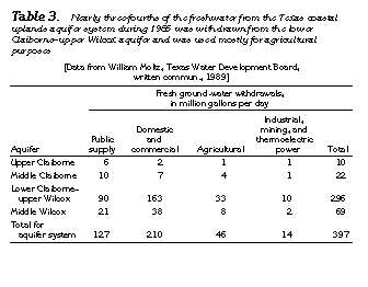
Table 3 Table listing withdrawals from each aquifer and their uses
(17K)
 editable eps file Etab3.eps.gz
(17K compressed)
editable eps file Etab3.eps.gz
(17K compressed)
Figure 75 Map showing potentiometric contour (33K)
 editable eps file E075.eps.gz
(66K compressed)
editable eps file E075.eps.gz
(66K compressed)
Table 4 Table listing withdrawals by county and their uses
(17K)
 editable eps file Etab4.eps.gz
(17K compressed)
editable eps file Etab4.eps.gz
(17K compressed)
Figure 76 Map showing decline in potentiometric surface (33K)
 editable eps file E076.eps.gz
(99K compressed)
editable eps file E076.eps.gz
(99K compressed)
 editable eps file Etab3.eps.gz
(17K compressed)
editable eps file Etab3.eps.gz
(17K compressed) 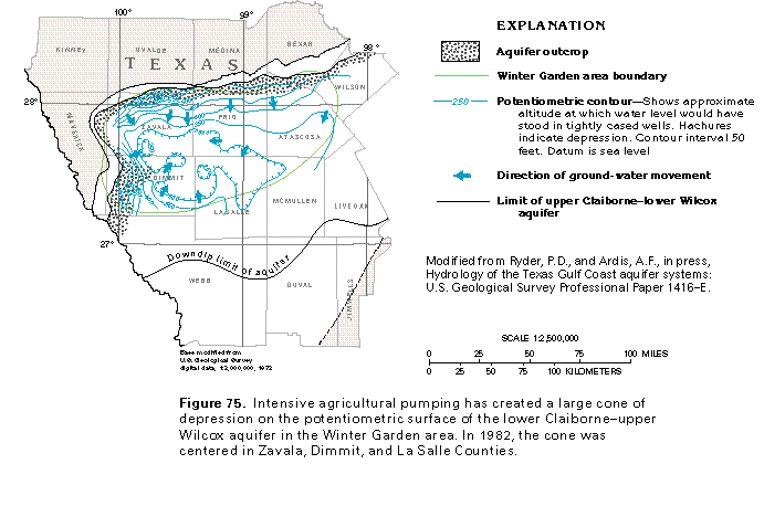 editable eps file E075.eps.gz
(66K compressed)
editable eps file E075.eps.gz
(66K compressed) 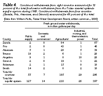 editable eps file Etab4.eps.gz
(17K compressed)
editable eps file Etab4.eps.gz
(17K compressed) 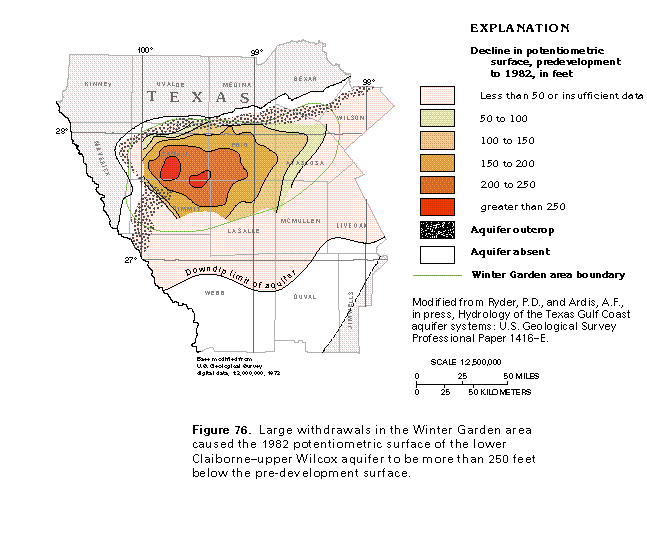 editable eps file E076.eps.gz
(99K compressed)
editable eps file E076.eps.gz
(99K compressed)